Crandall Peak Topo Map California
To zoom in, hover over the map of Crandall Peak
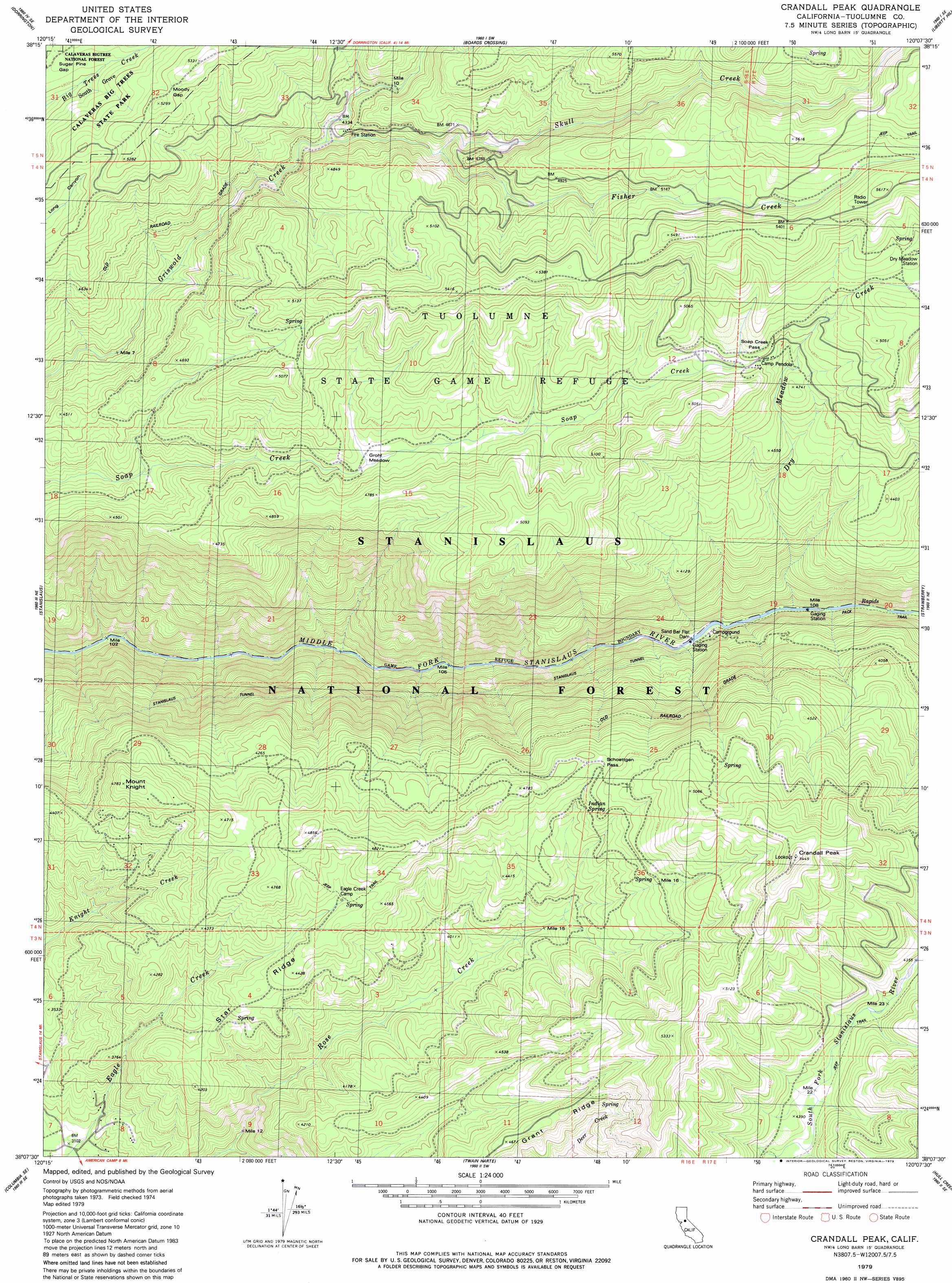
USGS Topo Quad 38120b2 - 1:24,000 scale
| Topo Map Name: | Crandall Peak |
| USGS Topo Quad ID: | 38120b2 |
| Print Size: | ca. 21 1/4" wide x 27" high |
| Southeast Coordinates: | 38.125° N latitude / 120.125° W longitude |
| Map Center Coordinates: | 38.1875° N latitude / 120.1875° W longitude |
| U.S. State: | CA |
| Filename: | o38120b2.jpg |
| Download Map JPG Image: | Crandall Peak topo map 1:24,000 scale |
| Map Type: | Topographic |
| Topo Series: | 7.5´ |
| Map Scale: | 1:24,000 |
| Source of Map Images: | United States Geological Survey (USGS) |
| Alternate Map Versions: |
Crandall Peak CA 1979, updated 1979 Download PDF Buy paper map Crandall Peak CA 1979, updated 1979 Download PDF Buy paper map Crandall Peak CA 2001, updated 2004 Download PDF Buy paper map Crandall Peak CA 2012 Download PDF Buy paper map Crandall Peak CA 2015 Download PDF Buy paper map |
| FStopo: | US Forest Service topo Crandall Peak is available: Download FStopo PDF Download FStopo TIF |
1:24,000 Topo Quads surrounding Crandall Peak
Devils Nose |
Garnet Hill |
Calaveras Dome |
Tamarack |
Spicer Meadow Res |
Fort Mountain |
Dorrington |
Boards Crossing |
Liberty Hill |
Donnell Lake |
Murphys |
Stanislaus |
Crandall Peak |
Strawberry |
Pinecrest |
Columbia |
Columbia Se |
Twain Harte |
Hull Creek |
Cherry Lake North |
Sonora |
Standard |
Tuolumne |
Duckwall Mountain |
Cherry Lake South |
> Back to 38120a1 at 1:100,000 scale
> Back to 38120a1 at 1:250,000 scale
> Back to U.S. Topo Maps home
Crandall Peak topo map: Gazetteer
Crandall Peak: Dams
Sand Bar Flat Dam elevation 830m 2723′Crandall Peak: Flats
Grohl Meadow elevation 1357m 4452′Schumake Meadow elevation 1616m 5301′
Crandall Peak: Gaps
Moody Gap elevation 1589m 5213′Schoettgen Pass elevation 1393m 4570′
Windy Gap elevation 1619m 5311′
Crandall Peak: Parks
Tuolumne State Game Refuge elevation 1631m 5351′Crandall Peak: Populated Places
Camp Pendola elevation 1463m 4799′Crandall Peak: Springs
Indian Spring elevation 1353m 4438′Crandall Peak: Streams
Dry Meadow Creek elevation 852m 2795′Fisher Creek elevation 1310m 4297′
Skull Creek elevation 1357m 4452′
Tunnel Creek elevation 1179m 3868′
Crandall Peak: Summits
Crandall Peak elevation 1664m 5459′Mount Knight elevation 1459m 4786′
Crandall Peak: Woods
South Grove elevation 1484m 4868′Crandall Peak digital topo map on disk
Buy this Crandall Peak topo map showing relief, roads, GPS coordinates and other geographical features, as a high-resolution digital map file on DVD: