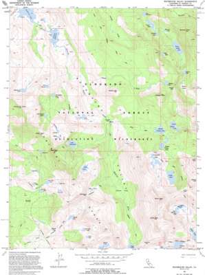
Rockbound Valley Topo Map California
To zoom in, hover over the map of Rockbound Valley
USGS Topo Quad 38120h2 - 1:24,000 scale
| Topo Map Name: | Rockbound Valley |
| USGS Topo Quad ID: | 38120h2 |
| Print Size: | ca. 21 1/4" wide x 27" high |
| Southeast Coordinates: | 38.875° N latitude / 120.125° W longitude |
| Map Center Coordinates: | 38.9375° N latitude / 120.1875° W longitude |
| U.S. State: | CA |
| Filename: | o38120h2.jpg |
| Download Map JPG Image: | Rockbound Valley topo map 1:24,000 scale |
| Map Type: | Topographic |
| Topo Series: | 7.5´ |
| Map Scale: | 1:24,000 |
| Source of Map Images: | United States Geological Survey (USGS) |
| Alternate Map Versions: |
Rockbound Valley CA 1955, updated 1956 Download PDF Buy paper map Rockbound Valley CA 1955, updated 1959 Download PDF Buy paper map Rockbound Valley CA 1955, updated 1971 Download PDF Buy paper map Rockbound Valley CA 1955, updated 1971 Download PDF Buy paper map Rockbound Valley CA 1992, updated 1994 Download PDF Buy paper map Rockbound Valley CA 2012 Download PDF Buy paper map Rockbound Valley CA 2015 Download PDF Buy paper map |
| FStopo: | US Forest Service topo Rockbound Valley is available: Download FStopo PDF Download FStopo TIF |
1:24,000 Topo Quads surrounding Rockbound Valley
> Back to 38120e1 at 1:100,000 scale
> Back to 38120a1 at 1:250,000 scale
> Back to U.S. Topo Maps home
Rockbound Valley topo map: Gazetteer
Rockbound Valley: Dams
Highland Lake 1-031 Dam elevation 2382m 7814′Rubicon 1009-009 Dam elevation 1989m 6525′
Schmidell Lake 1-029 Dam elevation 2402m 7880′
Stony Ridge Lake 1-032 Dam elevation 2382m 7814′
Rockbound Valley: Flats
Camper Flat elevation 2195m 7201′China Flat elevation 2290m 7513′
Onion Flat elevation 1997m 6551′
Willow Flat elevation 2245m 7365′
Rockbound Valley: Gaps
Dicks Pass elevation 2858m 9376′Mosquito Pass elevation 2569m 8428′
Phipps Pass elevation 2697m 8848′
Rockbound Pass elevation 2607m 8553′
Rockbound Valley: Lakes
Alta Morris Lake elevation 2478m 8129′Barrett Lake elevation 2328m 7637′
Cliff Lake elevation 2558m 8392′
Clyde Lake elevation 2457m 8061′
Crag Lake elevation 2278m 7473′
Dicks Lake elevation 2568m 8425′
Fontanillis Lake elevation 2527m 8290′
Four-Q Lakes elevation 2284m 7493′
Fox Lake elevation 1997m 6551′
Gertrude Lake elevation 2437m 7995′
Grouse Lakes elevation 2496m 8188′
Half Moon Lake elevation 2482m 8143′
Heather Lake elevation 2404m 7887′
Hidden Lake elevation 2293m 7522′
Highland Lake elevation 2382m 7814′
Horseshoe Lake elevation 2295m 7529′
Island Lake elevation 2485m 8152′
Kalmia Lake elevation 2616m 8582′
Lake Doris elevation 2548m 8359′
Lake Genevieve elevation 2260m 7414′
Lake Lois elevation 2526m 8287′
Lake Number Five elevation 2419m 7936′
Lake Number Nine elevation 2508m 8228′
Lake Number Three elevation 2507m 8225′
Lake Zitella elevation 2332m 7650′
Lawrence Lake elevation 2384m 7821′
Leland Lakes elevation 2487m 8159′
Lost Lake elevation 2374m 7788′
Lower Velma Lake elevation 2351m 7713′
Maude Lake elevation 2335m 7660′
McConnell Lake elevation 2385m 7824′
Middle Velma Lake elevation 2405m 7890′
Phipps Lake elevation 2604m 8543′
Rockbound Lake elevation 1990m 6528′
Rubicon Lake elevation 2528m 8293′
Shadow Lake elevation 2336m 7664′
Susie Lake elevation 2367m 7765′
Top Lake elevation 2520m 8267′
Tyler Lake elevation 2506m 8221′
Upper Velma Lake elevation 2427m 7962′
Rockbound Valley: Ranges
Crystal Range elevation 2803m 9196′Rockbound Valley: Reservoirs
Lake Schmidell elevation 2402m 7880′Rubicon Reservoir elevation 1989m 6525′
Stony Ridge Lake elevation 2382m 7814′
Rockbound Valley: Streams
Phipps Creek elevation 2086m 6843′Rockbound Valley: Summits
Dicks Peak elevation 3042m 9980′Jacks Peak elevation 3002m 9849′
McConnell Peak elevation 2770m 9087′
Middle Mountain elevation 2539m 8330′
Phipps Peak elevation 2813m 9229′
Red Peak elevation 2833m 9294′
Rubicon Peak elevation 2798m 9179′
Silver Peak elevation 2709m 8887′
Rockbound Valley: Valleys
Rockbound Valley elevation 1977m 6486′Rockbound Valley digital topo map on disk
Buy this Rockbound Valley topo map showing relief, roads, GPS coordinates and other geographical features, as a high-resolution digital map file on DVD:


