Terminous Topo Map California
To zoom in, hover over the map of Terminous
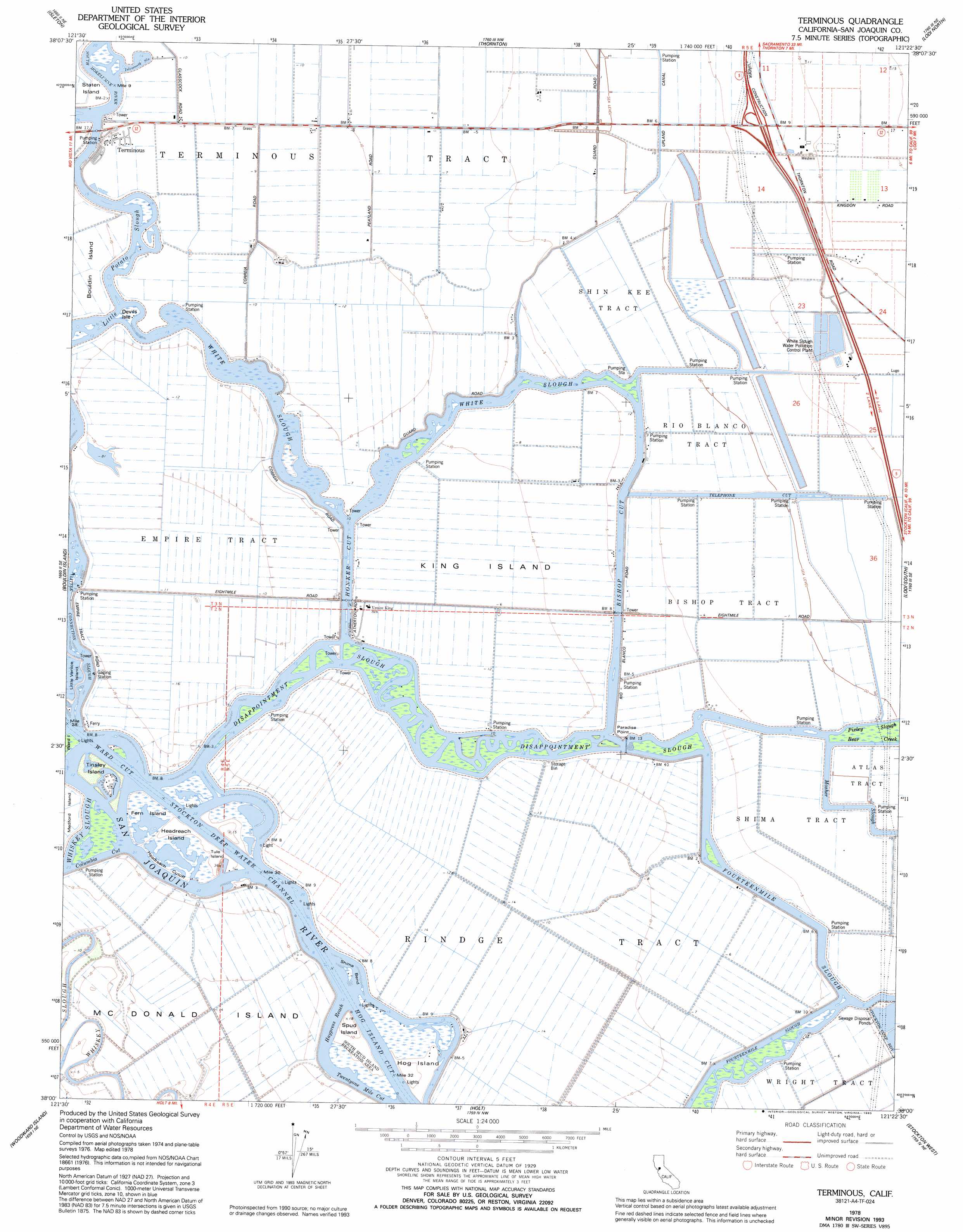
USGS Topo Quad 38121a4 - 1:24,000 scale
| Topo Map Name: | Terminous |
| USGS Topo Quad ID: | 38121a4 |
| Print Size: | ca. 21 1/4" wide x 27" high |
| Southeast Coordinates: | 38° N latitude / 121.375° W longitude |
| Map Center Coordinates: | 38.0625° N latitude / 121.4375° W longitude |
| U.S. State: | CA |
| Filename: | o38121a4.jpg |
| Download Map JPG Image: | Terminous topo map 1:24,000 scale |
| Map Type: | Topographic |
| Topo Series: | 7.5´ |
| Map Scale: | 1:24,000 |
| Source of Map Images: | United States Geological Survey (USGS) |
| Alternate Map Versions: |
Terminous CA 1952, updated 1953 Download PDF Buy paper map Terminous CA 1952, updated 1964 Download PDF Buy paper map Terminous CA 1952, updated 1969 Download PDF Buy paper map Terminous CA 1978, updated 1978 Download PDF Buy paper map Terminous CA 1978, updated 1993 Download PDF Buy paper map Terminous CA 1997, updated 2002 Download PDF Buy paper map Terminous CA 2012 Download PDF Buy paper map Terminous CA 2015 Download PDF Buy paper map |
1:24,000 Topo Quads surrounding Terminous
Liberty Island |
Courtland |
Bruceville |
Galt |
Clay |
Rio Vista |
Isleton |
Thornton |
Lodi North |
Lockeford |
Jersey Island |
Bouldin Island |
Terminous |
Lodi South |
Waterloo |
Brentwood |
Woodward Island |
Holt |
Stockton West |
Stockton East |
Byron Hot Springs |
Clifton Court Forebay |
Union Island |
Lathrop |
Manteca |
> Back to 38121a1 at 1:100,000 scale
> Back to 38120a1 at 1:250,000 scale
> Back to U.S. Topo Maps home
Terminous topo map: Gazetteer
Terminous: Airports
Lost Isle Seaplane Base elevation 1m 3′Terminous: Bends
Headreach Cutoff elevation 0m 0′Shima Bend elevation 0m 0′
Terminous: Canals
Bishop Cut elevation 1m 3′Hog Island Cut elevation 0m 0′
Honker Cut elevation 0m 0′
Telephone Cut elevation 0m 0′
Twentyone Mile Cut elevation 0m 0′
Ward Cut elevation 3m 9′
Terminous: Capes
Paradise Point elevation 0m 0′Terminous: Channels
Haypress Reach elevation 0m 0′Terminous: Guts
Disappointment Slough elevation 0m 0′Fourteenmile Slough elevation 0m 0′
Islemouth Slough elevation 1m 3′
Little Connection Slough elevation 1m 3′
Little Potato Slough elevation 0m 0′
Whiskey Slough elevation 0m 0′
White Slough elevation 1m 3′
Terminous: Islands
Devils Isle elevation 0m 0′Fern Island elevation 0m 0′
Headreach Island elevation 2m 6′
Hog Island elevation 4m 13′
King Island elevation -2m -7′
McDonald Island elevation -4m -14′
Spud Island elevation 4m 13′
Tinsley Island elevation 0m 0′
Tule Island elevation 10m 32′
Terminous: Parks
South Spud Island Recreation Area elevation 3m 9′Terminous: Populated Places
Terminous elevation -2m -7′Terminous: Streams
Bear Creek elevation 0m 0′Pixley Slough elevation 0m 0′
Terminous digital topo map on disk
Buy this Terminous topo map showing relief, roads, GPS coordinates and other geographical features, as a high-resolution digital map file on DVD: