Folsom Topo Map California
To zoom in, hover over the map of Folsom
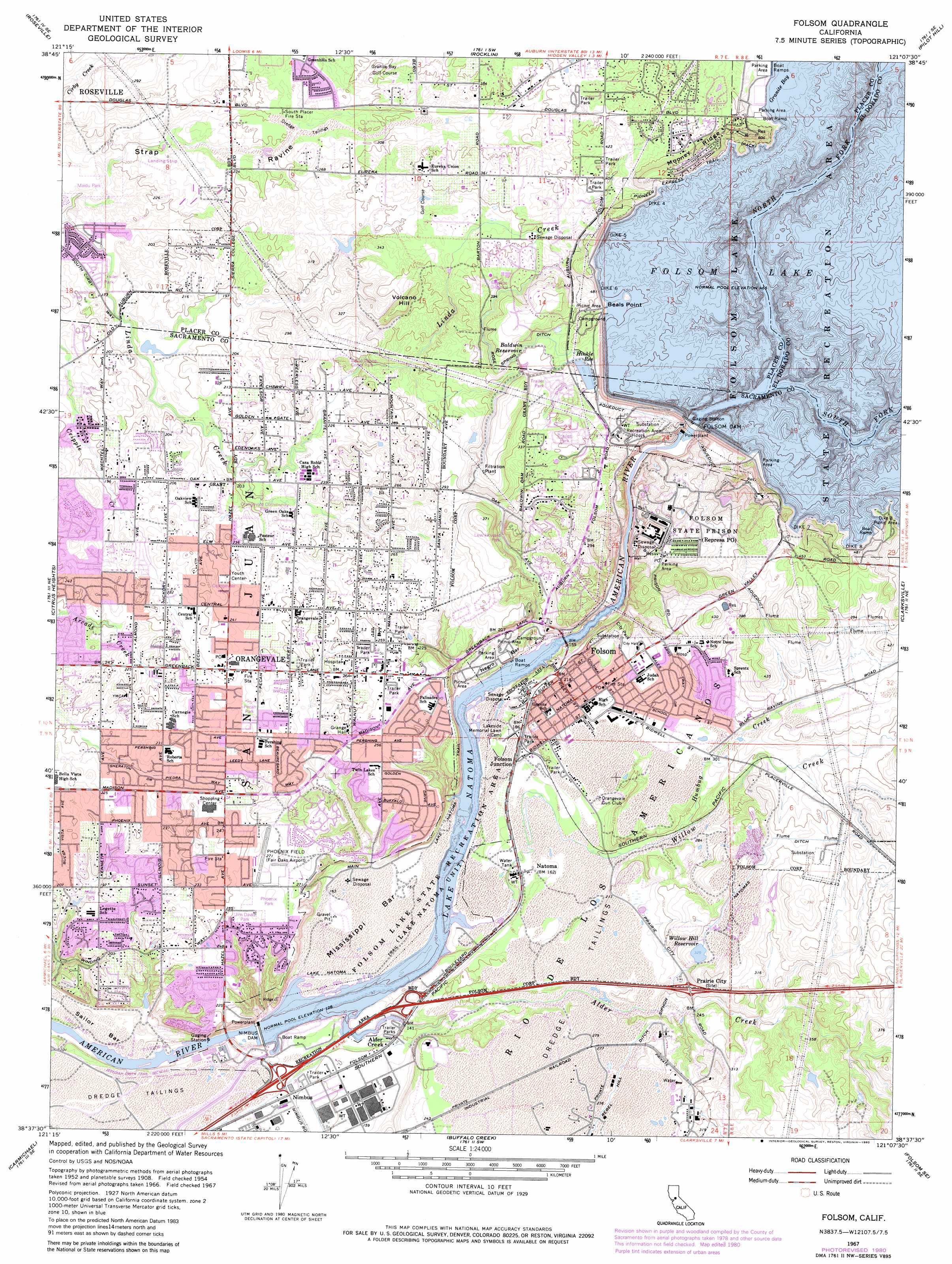
USGS Topo Quad 38121f2 - 1:24,000 scale
| Topo Map Name: | Folsom |
| USGS Topo Quad ID: | 38121f2 |
| Print Size: | ca. 21 1/4" wide x 27" high |
| Southeast Coordinates: | 38.625° N latitude / 121.125° W longitude |
| Map Center Coordinates: | 38.6875° N latitude / 121.1875° W longitude |
| U.S. State: | CA |
| Filename: | o38121f2.jpg |
| Download Map JPG Image: | Folsom topo map 1:24,000 scale |
| Map Type: | Topographic |
| Topo Series: | 7.5´ |
| Map Scale: | 1:24,000 |
| Source of Map Images: | United States Geological Survey (USGS) |
| Alternate Map Versions: |
Folsom CA 1954, updated 1955 Download PDF Buy paper map Folsom CA 1954, updated 1960 Download PDF Buy paper map Folsom CA 1967, updated 1968 Download PDF Buy paper map Folsom CA 1967, updated 1977 Download PDF Buy paper map Folsom CA 1967, updated 1980 Download PDF Buy paper map Folsom CA 1975, updated 1978 Download PDF Buy paper map Folsom CA 2012 Download PDF Buy paper map Folsom CA 2015 Download PDF Buy paper map |
1:24,000 Topo Quads surrounding Folsom
Sheridan |
Lincoln |
Gold Hill |
Auburn |
Greenwood |
Pleasant Grove |
Roseville |
Rocklin |
Pilot Hill |
Coloma |
Rio Linda |
Citrus Heights |
Folsom |
Clarksville |
Shingle Springs |
Sacramento East |
Carmichael |
Buffalo Creek |
Folsom Se |
Latrobe |
Florin |
Elk Grove |
Sloughhouse |
Carbondale |
Irish Hill |
> Back to 38121e1 at 1:100,000 scale
> Back to 38120a1 at 1:250,000 scale
> Back to U.S. Topo Maps home
Folsom topo map: Gazetteer
Folsom: Airports
Phoenix Field (historical) elevation 83m 272′Folsom: Bars
Mississippi Bar elevation 45m 147′Negro Bar elevation 51m 167′
Sailor Bar elevation 21m 68′
Folsom: Bridges
Rainbow Bridge elevation 35m 114′Folsom: Canals
Rose Spring Ditch elevation 125m 410′Folsom: Capes
Beals Point elevation 143m 469′Folsom: Crossings
Exit 21 elevation 43m 141′Exit 22 elevation 43m 141′
Exit 23 elevation 53m 173′
Exit 25 elevation 86m 282′
Folsom: Dams
Dike Eight elevation 144m 472′Dike Five elevation 143m 469′
Dike Four elevation 143m 469′
Dike Seven elevation 143m 469′
Dike Six elevation 143m 469′
Folsom Dam elevation 77m 252′
Folsom Dike 8 Dam elevation 148m 485′
Folsom Dikes 4,5 and 6 Dam elevation 143m 469′
Mount Stoneman 1-016 Dam elevation 145m 475′
Nimbus Dam elevation 33m 108′
Willow Hill 453-002 Dam elevation 99m 324′
Folsom: Flats
Nimbus Flat elevation 42m 137′Folsom: Parks
Almond Park elevation 73m 239′B T Collins Park elevation 124m 406′
Briggs Ranch Mini Park elevation 136m 446′
California Hills Neighborhood Park elevation 88m 288′
Community Center Park elevation 72m 236′
Dan Russell Rodeo Arena elevation 82m 269′
Dike Eight Picnic Area elevation 146m 479′
Ed Mitchell Park elevation 104m 341′
Folsom City Park elevation 90m 295′
Folsom City Zoo elevation 88m 288′
Folsom Lake State Recreation Area elevation 143m 469′
Folsom Powerhouse State Historic Park elevation 57m 187′
Folsom Recreation Center Sports Complex elevation 88m 288′
Granite Park elevation 78m 255′
Indian Stone Corral Park elevation 75m 246′
Jim David Park elevation 82m 269′
Lembi Park elevation 89m 291′
Lew Howard Park elevation 102m 334′
Little Phoenix Park elevation 82m 269′
Maidu Park elevation 53m 173′
Miller Park elevation 55m 180′
Natoma Station Neighborhood Park elevation 59m 193′
Negro Bar State Park elevation 36m 118′
Nimbus Dam Recreation Area elevation 39m 127′
Nimbus Dam State Historical Landmark elevation 34m 111′
Orangevale Community Park elevation 64m 209′
Orangevale Park elevation 75m 246′
Palisades Park elevation 82m 269′
Pecan Park elevation 66m 216′
Phoenix Park elevation 82m 269′
Santa Juanita Neighborhood Park elevation 94m 308′
Snipes-Pershing Park elevation 82m 269′
Steeplechase Mini Park elevation 88m 288′
Upper Sunrise Recreation Area elevation 31m 101′
Willow Creek Recreation Area elevation 40m 131′
Folsom: Populated Places
Alder Creek elevation 47m 154′Folsom elevation 67m 219′
Folsom Junction elevation 56m 183′
Gold River elevation 36m 118′
Natoma elevation 51m 167′
Nimbus elevation 44m 144′
Orangevale elevation 73m 239′
Prairie City elevation 86m 282′
Folsom: Post Offices
Folsom Post Office elevation 87m 285′Orangevale Post Office elevation 73m 239′
Repressa Post Office elevation 96m 314′
Folsom: Reservoirs
Baldwin Reservoir elevation 122m 400′Folsom Lake elevation 77m 252′
Hunkle Reservoir elevation 123m 403′
Lake Natoma elevation 33m 108′
North Fork Reservoir (historical) elevation 143m 469′
Willow Hill Reservoir elevation 99m 324′
Folsom: Ridges
Mooney Ridge elevation 174m 570′Folsom: Streams
Alder Creek elevation 33m 108′Humbug Creek elevation 74m 242′
North Fork American River elevation 143m 469′
Willow Creek elevation 39m 127′
Folsom: Summits
Volcano Hill elevation 129m 423′Folsom: Trails
Lake Natoma Trail elevation 77m 252′Pioneer Express Trail elevation 147m 482′
Folsom digital topo map on disk
Buy this Folsom topo map showing relief, roads, GPS coordinates and other geographical features, as a high-resolution digital map file on DVD: