Taylor Monument Topo Map California
To zoom in, hover over the map of Taylor Monument
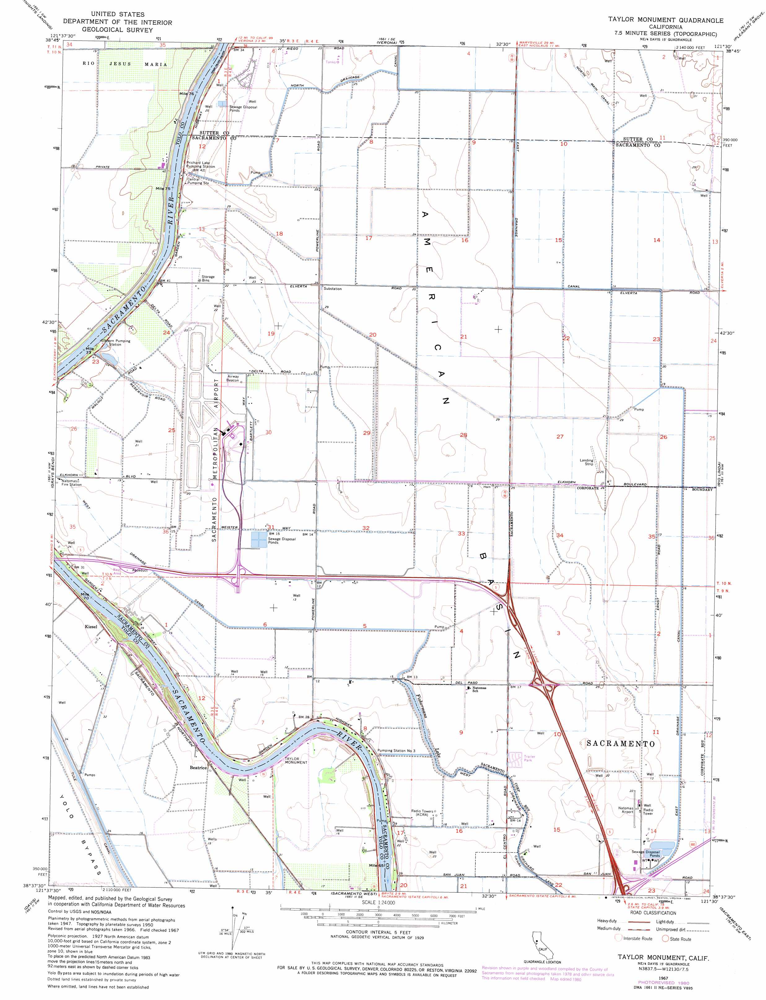
USGS Topo Quad 38121f5 - 1:24,000 scale
| Topo Map Name: | Taylor Monument |
| USGS Topo Quad ID: | 38121f5 |
| Print Size: | ca. 21 1/4" wide x 27" high |
| Southeast Coordinates: | 38.625° N latitude / 121.5° W longitude |
| Map Center Coordinates: | 38.6875° N latitude / 121.5625° W longitude |
| U.S. State: | CA |
| Filename: | o38121f5.jpg |
| Download Map JPG Image: | Taylor Monument topo map 1:24,000 scale |
| Map Type: | Topographic |
| Topo Series: | 7.5´ |
| Map Scale: | 1:24,000 |
| Source of Map Images: | United States Geological Survey (USGS) |
| Alternate Map Versions: |
Taylor Monument CA 1950, updated 1960 Download PDF Buy paper map Taylor Monument CA 1951, updated 1951 Download PDF Buy paper map Taylor Monument CA 1967, updated 1968 Download PDF Buy paper map Taylor Monument CA 1967, updated 1977 Download PDF Buy paper map Taylor Monument CA 1967, updated 1980 Download PDF Buy paper map Taylor Monument CA 1967, updated 1980 Download PDF Buy paper map Taylor Monument CA 2012 Download PDF Buy paper map Taylor Monument CA 2015 Download PDF Buy paper map |
1:24,000 Topo Quads surrounding Taylor Monument
Kirkville |
Sutter Causeway |
Nicolaus |
Sheridan |
Lincoln |
Eldorado Bend |
Knights Landing |
Verona |
Pleasant Grove |
Roseville |
Woodland |
Grays Bend |
Taylor Monument |
Rio Linda |
Citrus Heights |
Merritt |
Davis |
Sacramento West |
Sacramento East |
Carmichael |
Dixon |
Saxon |
Clarksburg |
Florin |
Elk Grove |
> Back to 38121e1 at 1:100,000 scale
> Back to 38120a1 at 1:250,000 scale
> Back to U.S. Topo Maps home
Taylor Monument topo map: Gazetteer
Taylor Monument: Airports
Natomas Airport (historical) elevation 6m 19′Sacramento International Airport elevation 8m 26′
Sopwith Farm Airport elevation 7m 22′
Taylor Monument: Bars
Sixmile Bar (historical) elevation 8m 26′Tenmile Shoals elevation 8m 26′
Twelvemile Bar elevation 8m 26′
Taylor Monument: Basins
American Basin elevation 6m 19′Taylor Monument: Canals
East Drainage Canal elevation 4m 13′Tule Canal elevation 5m 16′
West Drainage Canal elevation 4m 13′
Taylor Monument: Crossings
Dateys Ferry (historical) elevation 8m 26′Exit 307 elevation 7m 22′
Exit 522 elevation 7m 22′
Exit 525A elevation 13m 42′
Exit 525B elevation 13m 42′
Exit 528 elevation 5m 16′
Exit 86 elevation 4m 13′
Exit 88 elevation 4m 13′
Taylor Monument: Dams
Elkhorn Weir (historical) elevation 8m 26′Taylor Monument: Islands
Lonetree Island (historical) elevation 5m 16′Taylor Monument: Lakes
Todhunters Lake (historical) elevation 5m 16′Taylor Monument: Parks
Elkhorn Regional Park elevation 7m 22′Taylor Monument: Pillars
Taylor Monument elevation 7m 22′Taylor Monument: Populated Places
Beatrice elevation 8m 26′Kiesel elevation 8m 26′
Marty (historical) elevation 10m 32′
Vin elevation 9m 29′
Taylor Monument: Reservoirs
Fishermans Lake elevation 4m 13′Taylor Monument digital topo map on disk
Buy this Taylor Monument topo map showing relief, roads, GPS coordinates and other geographical features, as a high-resolution digital map file on DVD: