Woodland Topo Map California
To zoom in, hover over the map of Woodland
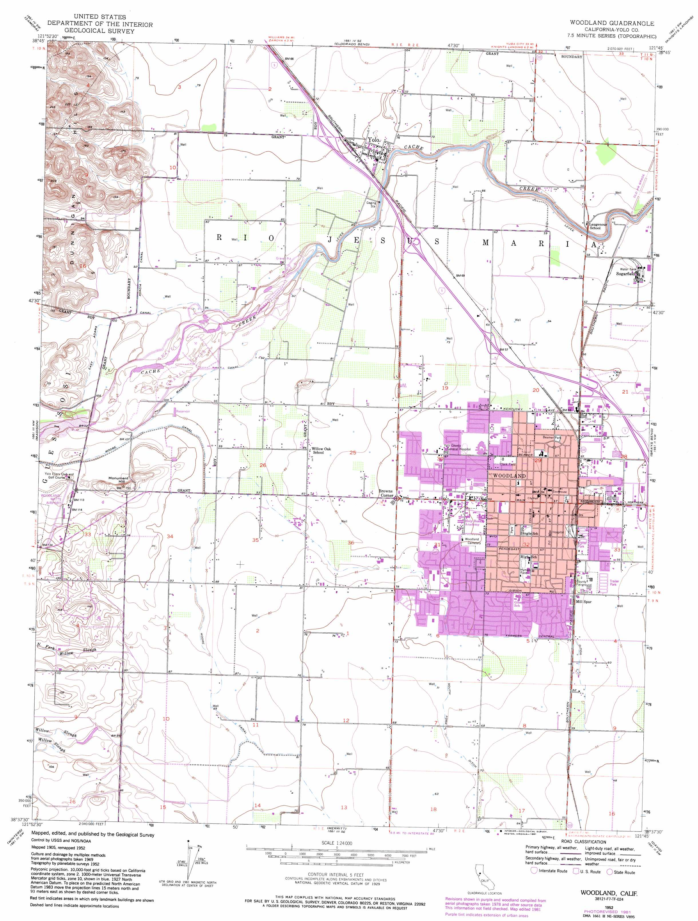
USGS Topo Quad 38121f7 - 1:24,000 scale
| Topo Map Name: | Woodland |
| USGS Topo Quad ID: | 38121f7 |
| Print Size: | ca. 21 1/4" wide x 27" high |
| Southeast Coordinates: | 38.625° N latitude / 121.75° W longitude |
| Map Center Coordinates: | 38.6875° N latitude / 121.8125° W longitude |
| U.S. State: | CA |
| Filename: | o38121f7.jpg |
| Download Map JPG Image: | Woodland topo map 1:24,000 scale |
| Map Type: | Topographic |
| Topo Series: | 7.5´ |
| Map Scale: | 1:24,000 |
| Source of Map Images: | United States Geological Survey (USGS) |
| Alternate Map Versions: |
Woodland CA 1952, updated 1959 Download PDF Buy paper map Woodland CA 1952, updated 1966 Download PDF Buy paper map Woodland CA 1952, updated 1977 Download PDF Buy paper map Woodland CA 1952, updated 1981 Download PDF Buy paper map Woodland CA 1952, updated 1991 Download PDF Buy paper map Woodland CA 2012 Download PDF Buy paper map Woodland CA 2015 Download PDF Buy paper map |
1:24,000 Topo Quads surrounding Woodland
Wildwood School |
Dunnigan |
Kirkville |
Sutter Causeway |
Nicolaus |
Bird Valley |
Zamora |
Eldorado Bend |
Knights Landing |
Verona |
Esparto |
Madison |
Woodland |
Grays Bend |
Taylor Monument |
Monticello Dam |
Winters |
Merritt |
Davis |
Sacramento West |
Mount Vaca |
Allendale |
Dixon |
Saxon |
Clarksburg |
> Back to 38121e1 at 1:100,000 scale
> Back to 38120a1 at 1:250,000 scale
> Back to U.S. Topo Maps home
Woodland topo map: Gazetteer
Woodland: Airports
Joe Heidrick Heliport elevation 27m 88′Watts - Woodland Airport elevation 36m 118′
Woodland: Canals
Acacia Canal elevation 29m 95′East Adams Canal elevation 32m 104′
Farmers Central Ditch elevation 22m 72′
Magnolia Canal elevation 29m 95′
Moore Canal elevation 29m 95′
South Fork Ditch elevation 22m 72′
Woodland: Parks
Beamer Park elevation 18m 59′Bemmerly Park elevation 21m 68′
Camarena Field elevation 20m 65′
Campbell Park elevation 18m 59′
Christiansen Park elevation 20m 65′
Clark Field elevation 20m 65′
Davis Estates Park elevation 21m 68′
Dubach Park elevation 17m 55′
Harris Park elevation 22m 72′
Holding Pond Park elevation 23m 75′
Hyman Field elevation 20m 65′
John Ferns Park elevation 25m 82′
Tredway Park elevation 20m 65′
William Crawford Senior Park elevation 22m 72′
Woodland Community Swimming Pool elevation 20m 65′
Woodside Park elevation 25m 82′
Yolo County Fairgrounds elevation 19m 62′
Woodland: Populated Places
Browns Corner elevation 23m 75′Elvaton (historical) elevation 27m 88′
Leisureville Mobile Home Park elevation 18m 59′
Mullen (historical) elevation 21m 68′
Peart (historical) elevation 19m 62′
Sugarfield elevation 18m 59′
Woodland elevation 21m 68′
Woodlands Mobile Home Park elevation 19m 62′
Yolo elevation 25m 82′
Woodland: Post Offices
Woodland Post Office elevation 21m 68′Yolo Post Office elevation 25m 82′
Woodland: Streams
Cache Creek elevation 16m 52′South Fork Willow Slough elevation 27m 88′
Woodland: Summits
Monument Hill elevation 48m 157′Woodland digital topo map on disk
Buy this Woodland topo map showing relief, roads, GPS coordinates and other geographical features, as a high-resolution digital map file on DVD: