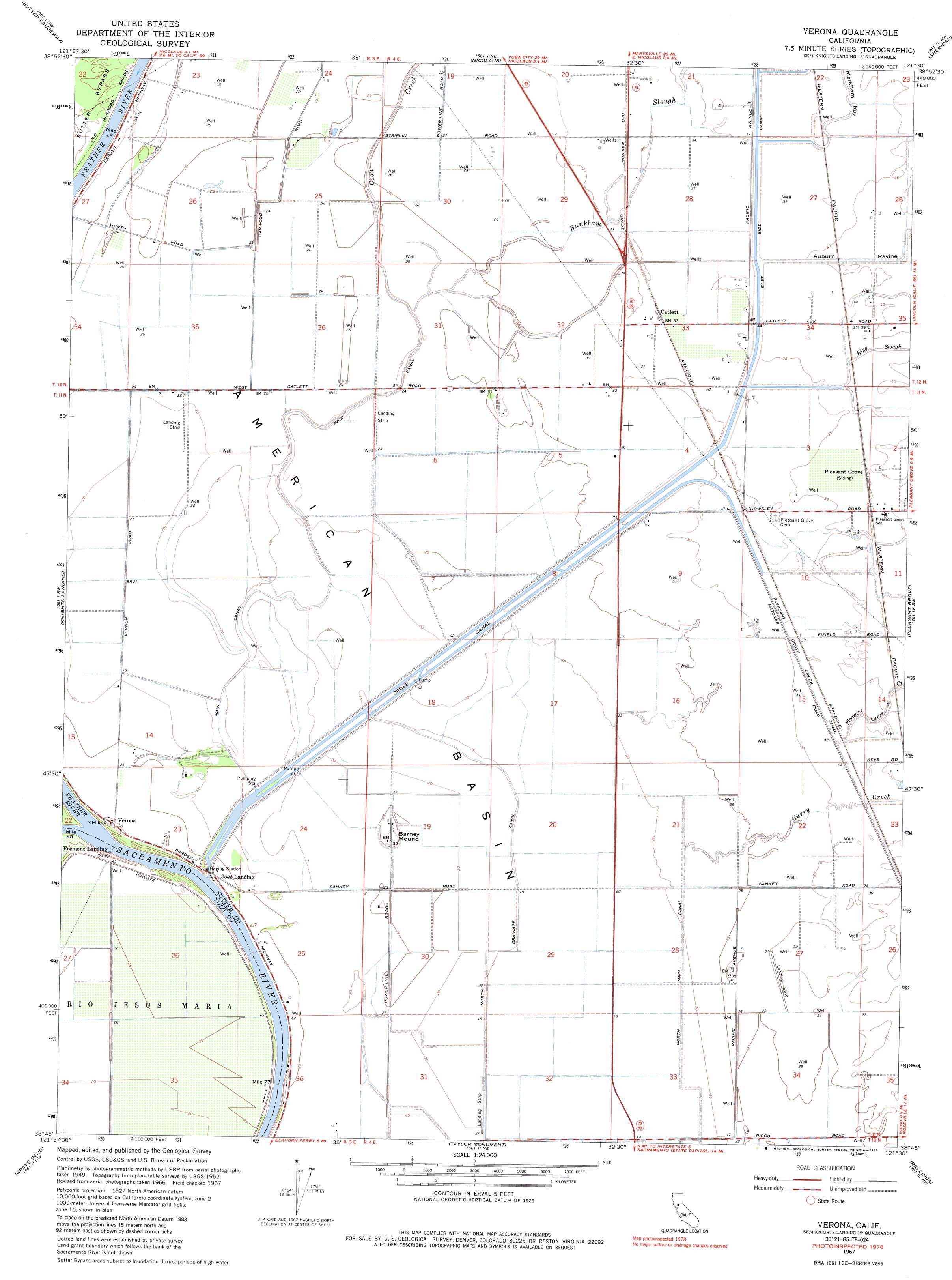
Verona Topo Map California
To zoom in, hover over the map of Verona
USGS Topo Quad 38121g5 - 1:24,000 scale
| Topo Map Name: | Verona |
| USGS Topo Quad ID: | 38121g5 |
| Print Size: | ca. 21 1/4" wide x 27" high |
| Southeast Coordinates: | 38.75° N latitude / 121.5° W longitude |
| Map Center Coordinates: | 38.8125° N latitude / 121.5625° W longitude |
| U.S. State: | CA |
| Filename: | o38121g5.jpg |
| Download Map JPG Image: | Verona topo map 1:24,000 scale |
| Map Type: | Topographic |
| Topo Series: | 7.5´ |
| Map Scale: | 1:24,000 |
| Source of Map Images: | United States Geological Survey (USGS) |
| Alternate Map Versions: |
Verona CA 1952, updated 1953 Download PDF Buy paper map Verona CA 1952, updated 1965 Download PDF Buy paper map Verona CA 1967, updated 1968 Download PDF Buy paper map Verona CA 1967, updated 1985 Download PDF Buy paper map Verona CA 2012 Download PDF Buy paper map Verona CA 2015 Download PDF Buy paper map |
1:24,000 Topo Quads surrounding Verona
Tisdale Weir |
Gilsizer Slough |
Olivehurst |
Wheatland |
Camp Far West |
Kirkville |
Sutter Causeway |
Nicolaus |
Sheridan |
Lincoln |
Eldorado Bend |
Knights Landing |
Verona |
Pleasant Grove |
Roseville |
Woodland |
Grays Bend |
Taylor Monument |
Rio Linda |
Citrus Heights |
Merritt |
Davis |
Sacramento West |
Sacramento East |
Carmichael |
> Back to 38121e1 at 1:100,000 scale
> Back to 38120a1 at 1:250,000 scale
> Back to U.S. Topo Maps home
Verona topo map: Gazetteer
Verona: Airports
James Brothers Airport elevation 11m 36′Lauppes Strip elevation 8m 26′
Riego Flight Strip elevation 6m 19′
Scheidel Ranch Airport elevation 9m 29′
Tenco Tractor Airport elevation 10m 32′
Vestal Strip elevation 7m 22′
Verona: Canals
Cross Canal elevation 6m 19′East Side Canal elevation 11m 36′
Main Canal elevation 6m 19′
North Drainage Canal elevation 6m 19′
North Main Canal elevation 7m 22′
Pleasant Grove Creek Canal elevation 10m 32′
Verona: Lakes
Murphy Lake (historical) elevation 6m 19′Verona: Populated Places
Catlett elevation 11m 36′Joes Landing elevation 7m 22′
Striplin (historical) elevation 11m 36′
Verona elevation 9m 29′
Verona: Streams
Coon Creek elevation 7m 22′Curry Creek elevation 7m 22′
Feather River elevation 8m 26′
King Slough elevation 12m 39′
Pleasant Grove Creek elevation 11m 36′
Verona: Summits
Barney Mound elevation 10m 32′Verona: Valleys
Auburn Ravine elevation 13m 42′Markham Ravine elevation 13m 42′
Verona digital topo map on disk
Buy this Verona topo map showing relief, roads, GPS coordinates and other geographical features, as a high-resolution digital map file on DVD: