Knights Landing Topo Map California
To zoom in, hover over the map of Knights Landing
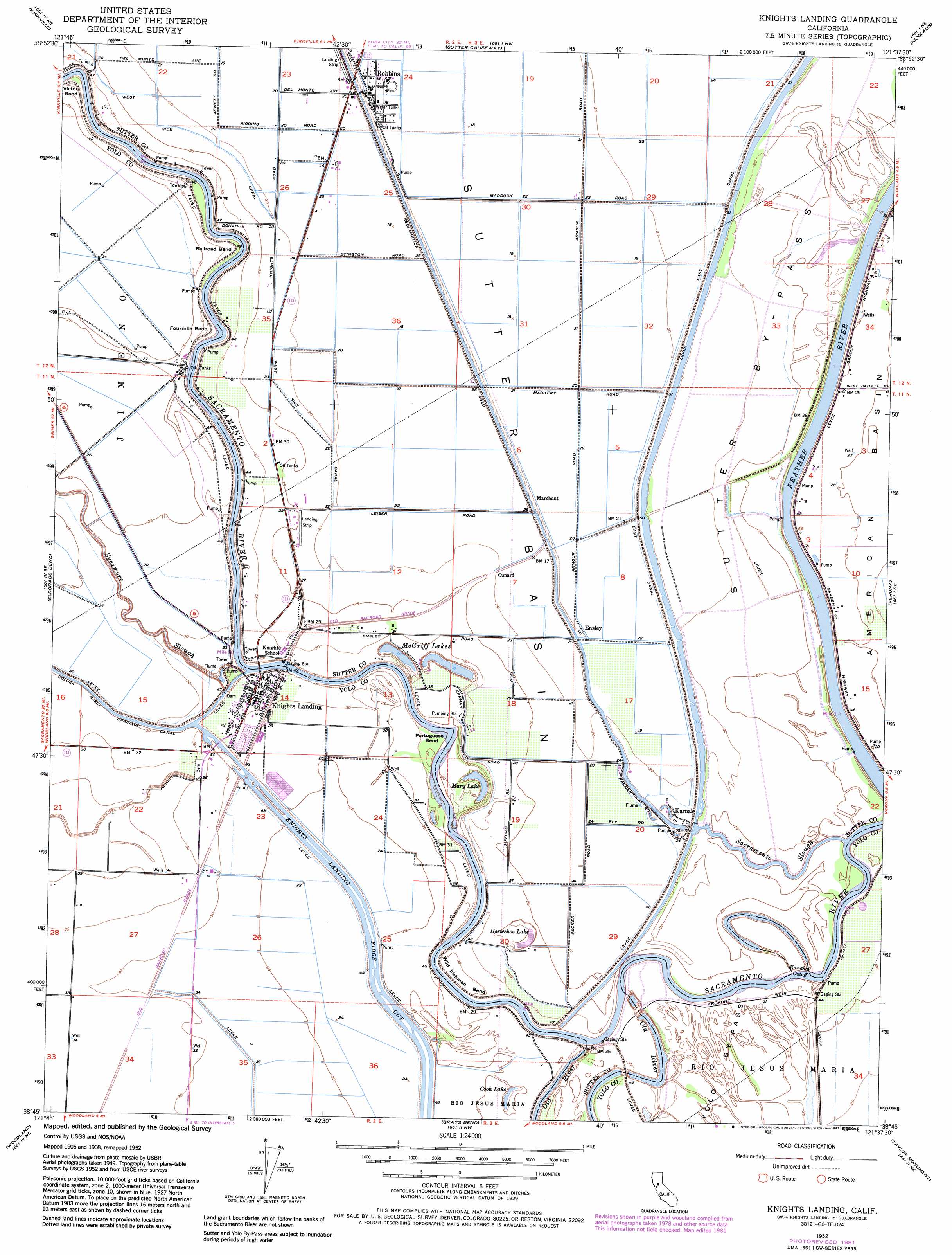
USGS Topo Quad 38121g6 - 1:24,000 scale
| Topo Map Name: | Knights Landing |
| USGS Topo Quad ID: | 38121g6 |
| Print Size: | ca. 21 1/4" wide x 27" high |
| Southeast Coordinates: | 38.75° N latitude / 121.625° W longitude |
| Map Center Coordinates: | 38.8125° N latitude / 121.6875° W longitude |
| U.S. State: | CA |
| Filename: | o38121g6.jpg |
| Download Map JPG Image: | Knights Landing topo map 1:24,000 scale |
| Map Type: | Topographic |
| Topo Series: | 7.5´ |
| Map Scale: | 1:24,000 |
| Source of Map Images: | United States Geological Survey (USGS) |
| Alternate Map Versions: |
Knights Landing CA 1952, updated 1964 Download PDF Buy paper map Knights Landing CA 1952, updated 1974 Download PDF Buy paper map Knights Landing CA 1952, updated 1981 Download PDF Buy paper map Knights Landing CA 1952, updated 1984 Download PDF Buy paper map Knights Landing CA 1952, updated 1987 Download PDF Buy paper map Knights Landing CA 2012 Download PDF Buy paper map Knights Landing CA 2015 Download PDF Buy paper map |
1:24,000 Topo Quads surrounding Knights Landing
Grimes |
Tisdale Weir |
Gilsizer Slough |
Olivehurst |
Wheatland |
Dunnigan |
Kirkville |
Sutter Causeway |
Nicolaus |
Sheridan |
Zamora |
Eldorado Bend |
Knights Landing |
Verona |
Pleasant Grove |
Madison |
Woodland |
Grays Bend |
Taylor Monument |
Rio Linda |
Winters |
Merritt |
Davis |
Sacramento West |
Sacramento East |
> Back to 38121e1 at 1:100,000 scale
> Back to 38120a1 at 1:250,000 scale
> Back to U.S. Topo Maps home
Knights Landing topo map: Gazetteer
Knights Landing: Airports
Bobs Flying Service Incorporated Airport elevation 8m 26′Sunrise Dusters Airport elevation 7m 22′
Wagner Aviation Airport elevation 7m 22′
Knights Landing: Bends
Fourmile Bend elevation 11m 36′Portuguese Bend elevation 9m 29′
Railroad Bend elevation 10m 32′
Victor Bend elevation 10m 32′
Wild Irishman Bend elevation 9m 29′
Knights Landing: Canals
Kanaka Cutoff elevation 9m 29′Knights Landing Ridge Cut elevation 8m 26′
Knights Landing: Guts
Sacramento Slough elevation 8m 26′Knights Landing: Lakes
Coon Lake elevation 7m 22′Horseshoe Lake elevation 7m 22′
Mary Lake elevation 7m 22′
McGriff Lakes elevation 6m 19′
Knights Landing: Levees
Fremont Weir elevation 9m 29′Knights Landing: Parks
Fremont Weir State Wildlife Area elevation 10m 32′Knights Landing: Populated Places
Cunard elevation 8m 26′Ensley elevation 7m 22′
Karnak elevation 7m 22′
Knights Landing elevation 11m 36′
Marchant elevation 6m 19′
Robbins elevation 7m 22′
Knights Landing: Post Offices
Knights Landing Post Office elevation 11m 36′Robbins Post Office elevation 7m 22′
Knights Landing digital topo map on disk
Buy this Knights Landing topo map showing relief, roads, GPS coordinates and other geographical features, as a high-resolution digital map file on DVD: