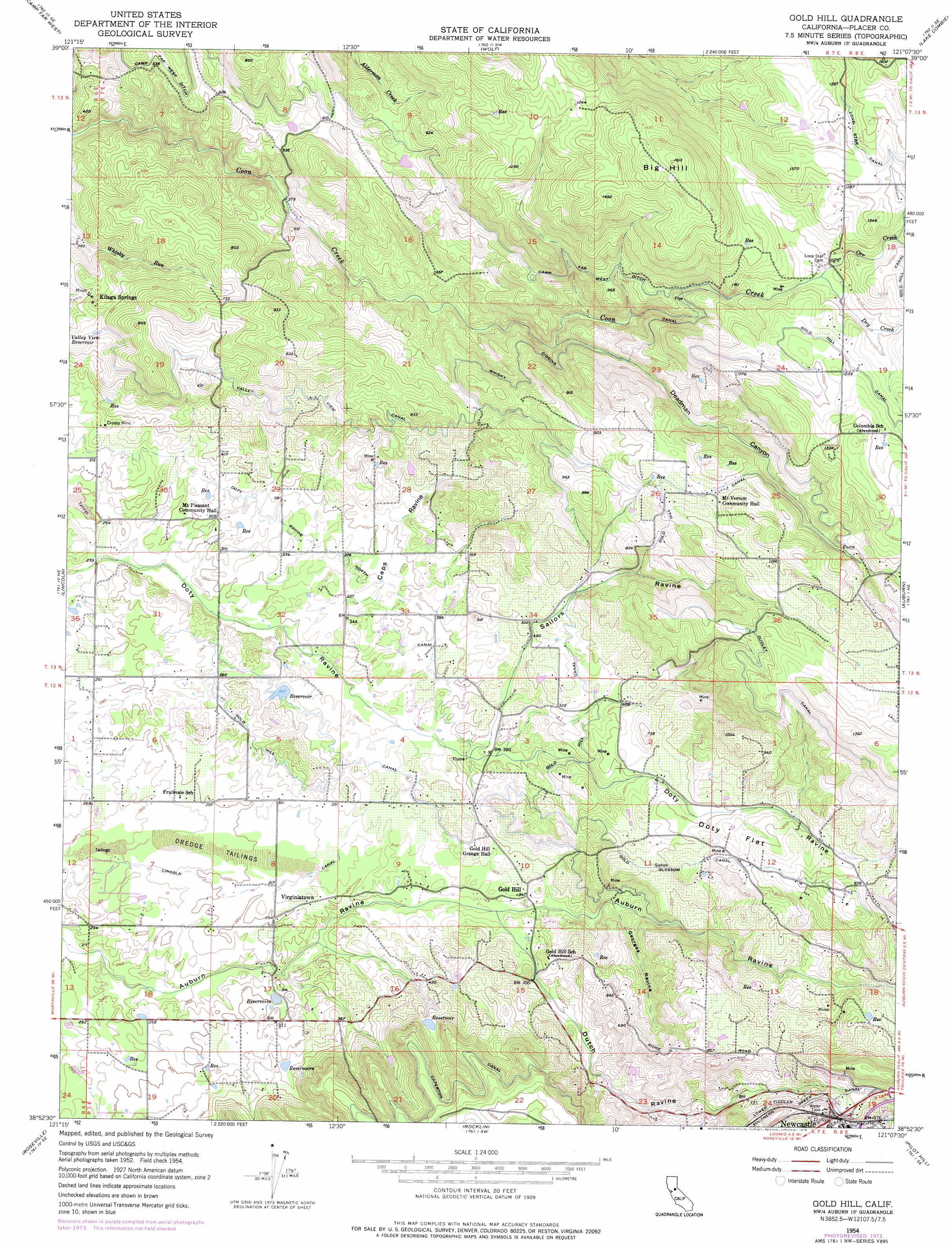
Gold Hill Topo Map California
To zoom in, hover over the map of Gold Hill
USGS Topo Quad 38121h2 - 1:24,000 scale
| Topo Map Name: | Gold Hill |
| USGS Topo Quad ID: | 38121h2 |
| Print Size: | ca. 21 1/4" wide x 27" high |
| Southeast Coordinates: | 38.875° N latitude / 121.125° W longitude |
| Map Center Coordinates: | 38.9375° N latitude / 121.1875° W longitude |
| U.S. State: | CA |
| Filename: | o38121h2.jpg |
| Download Map JPG Image: | Gold Hill topo map 1:24,000 scale |
| Map Type: | Topographic |
| Topo Series: | 7.5´ |
| Map Scale: | 1:24,000 |
| Source of Map Images: | United States Geological Survey (USGS) |
| Alternate Map Versions: |
Gold Hill CA 1954, updated 1955 Download PDF Buy paper map Gold Hill CA 1954, updated 1963 Download PDF Buy paper map Gold Hill CA 1954, updated 1976 Download PDF Buy paper map Gold Hill CA 1954, updated 1976 Download PDF Buy paper map Gold Hill CA 2012 Download PDF Buy paper map Gold Hill CA 2015 Download PDF Buy paper map |
1:24,000 Topo Quads surrounding Gold Hill
Browns Valley |
Smartville |
Rough And Ready |
Grass Valley |
Chicago Park |
Wheatland |
Camp Far West |
Wolf |
Lake Combie |
Colfax |
Sheridan |
Lincoln |
Gold Hill |
Auburn |
Greenwood |
Pleasant Grove |
Roseville |
Rocklin |
Pilot Hill |
Coloma |
Rio Linda |
Citrus Heights |
Folsom |
Clarksville |
Shingle Springs |
> Back to 38121e1 at 1:100,000 scale
> Back to 38120a1 at 1:250,000 scale
> Back to U.S. Topo Maps home
Gold Hill topo map: Gazetteer
Gold Hill: Canals
Caperton Canal elevation 221m 725′Doty Ravine North Canal elevation 110m 360′
Dudley Canal elevation 351m 1151′
Gold Blossom Canal elevation 215m 705′
Lincoln Canal elevation 95m 311′
Lower Fiddler Green Canal elevation 268m 879′
Valley View Canal elevation 191m 626′
Whisky Diggins Canal elevation 200m 656′
Gold Hill: Crossings
Exit 116 elevation 275m 902′Gold Hill: Dams
Columbian 321 Dam elevation 162m 531′Gold Hill: Flats
Doty Flat elevation 232m 761′Gold Hill: Mines
Crosby Mine elevation 111m 364′Gold Hill: Populated Places
Gold Hill elevation 108m 354′Kilaga Springs elevation 155m 508′
Virginiatown elevation 98m 321′
Gold Hill: Reservoirs
Valley View Reservoir elevation 175m 574′Gold Hill: Streams
Dry Creek elevation 322m 1056′Orr Creek elevation 321m 1053′
Gold Hill: Summits
Big Hill elevation 483m 1584′Gold Hill: Valleys
Caps Ravine elevation 93m 305′Deadman Canyon elevation 180m 590′
Dutch Ravine elevation 99m 324′
Georges Ravine elevation 127m 416′
Sailors Ravine elevation 114m 374′
Gold Hill digital topo map on disk
Buy this Gold Hill topo map showing relief, roads, GPS coordinates and other geographical features, as a high-resolution digital map file on DVD: