Nicolaus Topo Map California
To zoom in, hover over the map of Nicolaus
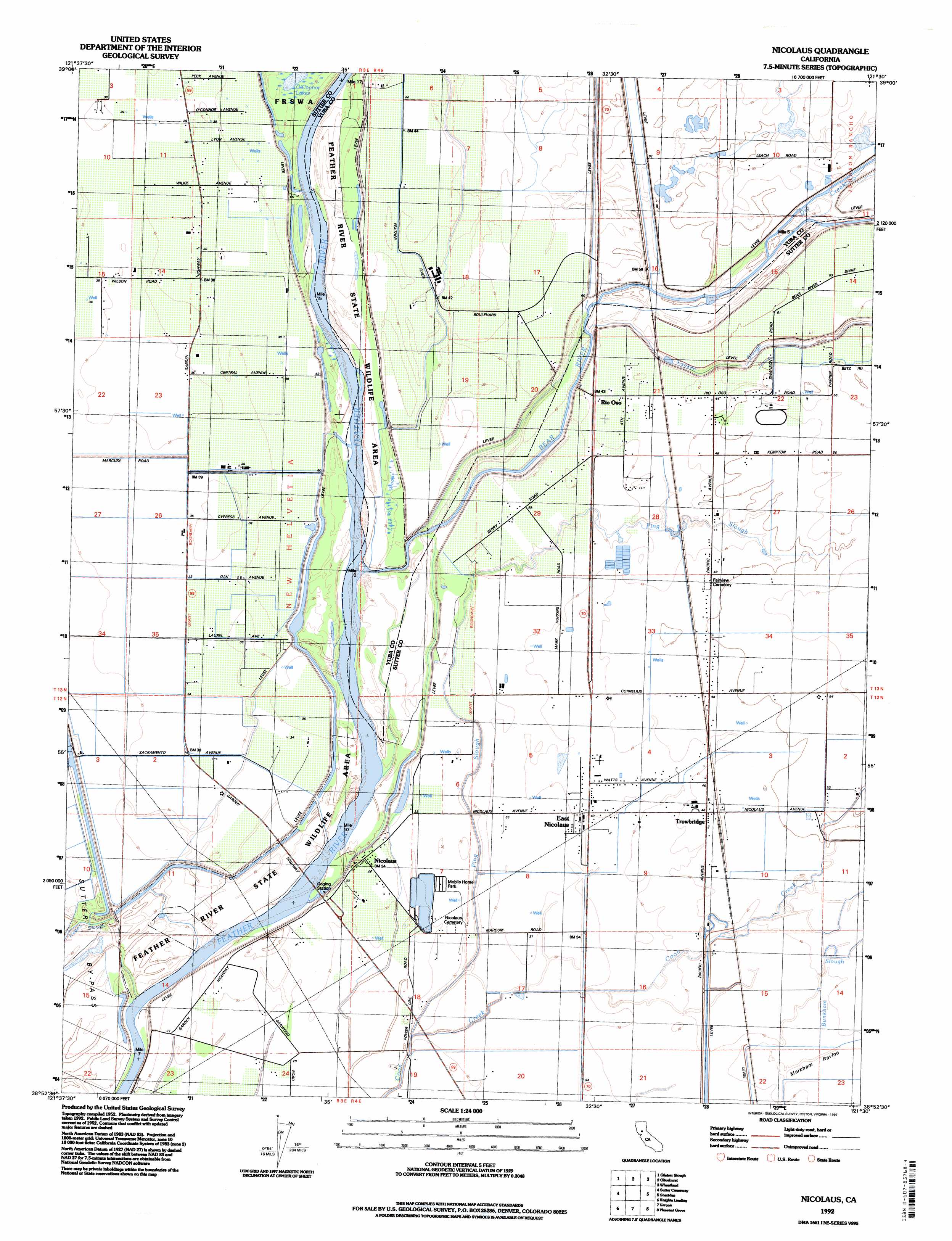
USGS Topo Quad 38121h5 - 1:24,000 scale
| Topo Map Name: | Nicolaus |
| USGS Topo Quad ID: | 38121h5 |
| Print Size: | ca. 21 1/4" wide x 27" high |
| Southeast Coordinates: | 38.875° N latitude / 121.5° W longitude |
| Map Center Coordinates: | 38.9375° N latitude / 121.5625° W longitude |
| U.S. State: | CA |
| Filename: | o38121h5.jpg |
| Download Map JPG Image: | Nicolaus topo map 1:24,000 scale |
| Map Type: | Topographic |
| Topo Series: | 7.5´ |
| Map Scale: | 1:24,000 |
| Source of Map Images: | United States Geological Survey (USGS) |
| Alternate Map Versions: |
Nicolaus CA 1952, updated 1953 Download PDF Buy paper map Nicolaus CA 1952, updated 1965 Download PDF Buy paper map Nicolaus CA 1952, updated 1974 Download PDF Buy paper map Nicolaus CA 1952, updated 1981 Download PDF Buy paper map Nicolaus CA 1992, updated 1997 Download PDF Buy paper map Nicolaus CA 2012 Download PDF Buy paper map Nicolaus CA 2015 Download PDF Buy paper map |
1:24,000 Topo Quads surrounding Nicolaus
Sutter Buttes |
Sutter |
Yuba City |
Browns Valley |
Smartville |
Tisdale Weir |
Gilsizer Slough |
Olivehurst |
Wheatland |
Camp Far West |
Kirkville |
Sutter Causeway |
Nicolaus |
Sheridan |
Lincoln |
Eldorado Bend |
Knights Landing |
Verona |
Pleasant Grove |
Roseville |
Woodland |
Grays Bend |
Taylor Monument |
Rio Linda |
Citrus Heights |
> Back to 38121e1 at 1:100,000 scale
> Back to 38120a1 at 1:250,000 scale
> Back to U.S. Topo Maps home
Nicolaus topo map: Gazetteer
Nicolaus: Guts
Bunkham Slough elevation 13m 42′Nelson Slough elevation 9m 29′
Nicolaus: Lakes
Lake of The Woods elevation 10m 32′O'Connor Lakes elevation 11m 36′
Nicolaus: Parks
Lake of the Woods State Wildlife Area elevation 10m 32′Nicolaus: Populated Places
Algodon (historical) elevation 16m 52′Chandler (historical) elevation 9m 29′
Cornelius (historical) elevation 13m 42′
East Nicolaus elevation 13m 42′
Nicolaus elevation 11m 36′
Rio Oso elevation 13m 42′
Trowbridge elevation 15m 49′
Nicolaus: Post Offices
East Nicolaus Post Office elevation 13m 42′Rio Oso Post Office elevation 15m 49′
Nicolaus: Streams
Bear River elevation 7m 22′Dry Creek elevation 14m 45′
Grasshopper Slough elevation 18m 59′
Ping Slough elevation 8m 26′
Yankee Slough elevation 12m 39′
Nicolaus digital topo map on disk
Buy this Nicolaus topo map showing relief, roads, GPS coordinates and other geographical features, as a high-resolution digital map file on DVD: