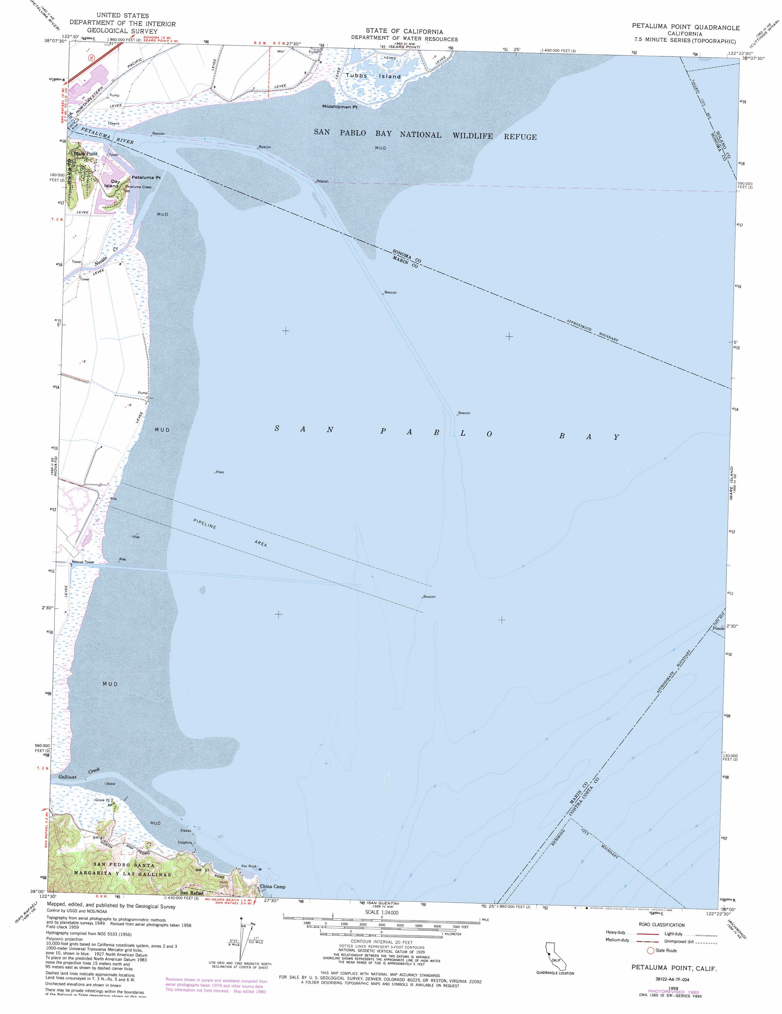
Petaluma Point Topo Map California
To zoom in, hover over the map of Petaluma Point
USGS Topo Quad 38122a4 - 1:24,000 scale
| Topo Map Name: | Petaluma Point |
| USGS Topo Quad ID: | 38122a4 |
| Print Size: | ca. 21 1/4" wide x 27" high |
| Southeast Coordinates: | 38° N latitude / 122.375° W longitude |
| Map Center Coordinates: | 38.0625° N latitude / 122.4375° W longitude |
| U.S. State: | CA |
| Filename: | o38122a4.jpg |
| Download Map JPG Image: | Petaluma Point topo map 1:24,000 scale |
| Map Type: | Topographic |
| Topo Series: | 7.5´ |
| Map Scale: | 1:24,000 |
| Source of Map Images: | United States Geological Survey (USGS) |
| Alternate Map Versions: |
Petaluma Point CA 1951, updated 1951 Download PDF Buy paper map Petaluma Point CA 1959, updated 1960 Download PDF Buy paper map Petaluma Point CA 1959, updated 1965 Download PDF Buy paper map Petaluma Point CA 1959, updated 1969 Download PDF Buy paper map Petaluma Point CA 1959, updated 1975 Download PDF Buy paper map Petaluma Point CA 1959, updated 1981 Download PDF Buy paper map Petaluma Point CA 1959, updated 1985 Download PDF Buy paper map Petaluma Point CA 2012 Download PDF Buy paper map Petaluma Point CA 2015 Download PDF Buy paper map |
1:24,000 Topo Quads surrounding Petaluma Point
Cotati |
Glen Ellen |
Sonoma |
Napa |
Mount George |
Petaluma |
Petaluma River |
Sears Point |
Cuttings Wharf |
Cordelia |
San Geronimo |
Novato |
Petaluma Point |
Mare Island |
Benicia |
Bolinas |
San Rafael |
San Quentin |
Richmond |
Briones Valley |
Point Bonita |
San Francisco North |
Oakland West |
Oakland East |
> Back to 38122a1 at 1:100,000 scale
> Back to 38122a1 at 1:250,000 scale
> Back to U.S. Topo Maps home
Petaluma Point topo map: Gazetteer
Petaluma Point: Bars
Bullhead Flat elevation 2m 6′Rat Rock elevation 0m 0′
Petaluma Point: Bays
Rat Rock Cove elevation 2m 6′San Pablo Bay elevation 0m 0′
Petaluma Point: Capes
Buckeye Point elevation 6m 19′China Camp Point elevation 0m 0′
Five Pine Point elevation 6m 19′
Midshipman Point elevation 2m 6′
Petaluma Point elevation 7m 22′
Weber Point elevation 1m 3′
Petaluma Point: Flats
Back Ranch Meadows elevation 5m 16′Miwok Meadows elevation 4m 13′
Petaluma Point: Islands
Day Island elevation 30m 98′Jakes Island elevation 9m 29′
Petaluma Point: Parks
China Camp Historic Area elevation 8m 26′China Camp State Park elevation 6m 19′
Petaluma Point: Populated Places
Rose (historical) elevation 2m 6′Petaluma Point: Streams
Gallinas Creek elevation 0m 0′Miller Creek elevation 0m 0′
Novato Creek elevation 2m 6′
Petaluma River elevation 0m 0′
Tolay Creek elevation 2m 6′
Petaluma Point: Summits
Bullet Hill elevation 14m 45′Chicken Coop Hill elevation 20m 65′
Turtle Back elevation 37m 121′
Petaluma Point: Trails
Back Ranch Meadows Fire Trail elevation 26m 85′Jakes Island Trail elevation 6m 19′
Miwok Fire Trail elevation 83m 272′
Pickleweed Marsh Trail elevation 7m 22′
Ridge Fire Trail elevation 89m 291′
Shoreline Trail elevation 14m 45′
Petaluma Point digital topo map on disk
Buy this Petaluma Point topo map showing relief, roads, GPS coordinates and other geographical features, as a high-resolution digital map file on DVD: