Inverness Topo Map California
To zoom in, hover over the map of Inverness
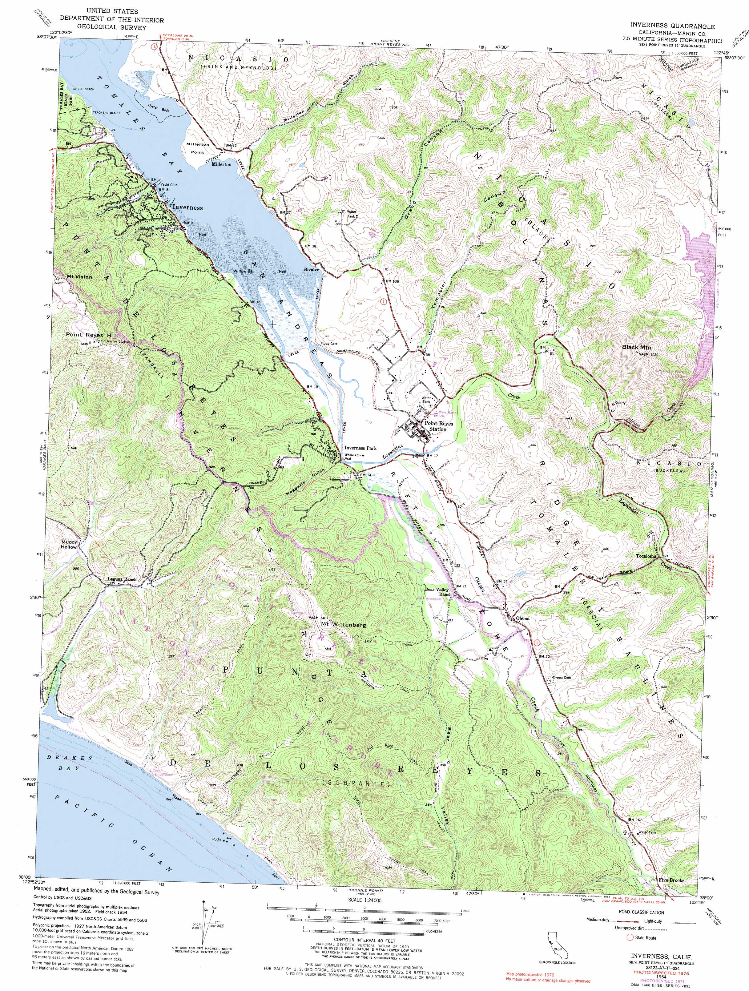
USGS Topo Quad 38122a7 - 1:24,000 scale
| Topo Map Name: | Inverness |
| USGS Topo Quad ID: | 38122a7 |
| Print Size: | ca. 21 1/4" wide x 27" high |
| Southeast Coordinates: | 38° N latitude / 122.75° W longitude |
| Map Center Coordinates: | 38.0625° N latitude / 122.8125° W longitude |
| U.S. State: | CA |
| Filename: | o38122a7.jpg |
| Download Map JPG Image: | Inverness topo map 1:24,000 scale |
| Map Type: | Topographic |
| Topo Series: | 7.5´ |
| Map Scale: | 1:24,000 |
| Source of Map Images: | United States Geological Survey (USGS) |
| Alternate Map Versions: |
Inverness CA 1954, updated 1955 Download PDF Buy paper map Inverness CA 1954, updated 1960 Download PDF Buy paper map Inverness CA 1954, updated 1972 Download PDF Buy paper map Inverness CA 1954, updated 1980 Download PDF Buy paper map Inverness CA 1954, updated 1985 Download PDF Buy paper map Inverness CA 1954, updated 1985 Download PDF Buy paper map Inverness CA 2012 Download PDF Buy paper map Inverness CA 2015 Download PDF Buy paper map |
1:24,000 Topo Quads surrounding Inverness
Bodega Head |
Valley Ford |
Two Rock |
Cotati |
Glen Ellen |
Tomales |
Point Reyes Ne |
Petaluma |
Petaluma River |
|
Drakes Bay |
Inverness |
San Geronimo |
Novato |
|
Double Point |
Bolinas |
San Rafael |
||
Point Bonita |
> Back to 38122a1 at 1:100,000 scale
> Back to 38122a1 at 1:250,000 scale
> Back to U.S. Topo Maps home
Inverness topo map: Gazetteer
Inverness: Basins
Muddy Hollow elevation 32m 104′Inverness: Beaches
Alan Sieroty Beach elevation 11m 36′Santa Maria Beach elevation 3m 9′
Sculptured Beach elevation 10m 32′
Shell Beach elevation 0m 0′
Teachers Beach elevation 10m 32′
Inverness: Capes
Millerton Point elevation 13m 42′Willow Point elevation 11m 36′
Inverness: Dams
Nicasio Dam elevation 44m 144′Rogers Dam elevation 41m 134′
Inverness: Flats
Divide Meadow elevation 99m 324′Inverness: Parks
Martinelli Park elevation 9m 29′Tomales Bay Ecological Reserve elevation 4m 13′
Inverness: Populated Places
Bivalve elevation 13m 42′Five Brooks elevation 59m 193′
Inverness elevation 13m 42′
Inverness Park elevation 45m 147′
Millerton elevation 13m 42′
Olema elevation 21m 68′
Point Reyes Station elevation 12m 39′
Seahaven elevation 54m 177′
Tocaloma elevation 23m 75′
Inverness: Post Offices
Inverness Post Office elevation 9m 29′Olema Post Office elevation 18m 59′
Point Reyes Station Post Office elevation 12m 39′
Inverness: Reservoirs
Nicasio Reservoir elevation 44m 144′Inverness: Streams
Lagunitas Creek elevation 0m 0′Nicasio Creek elevation 12m 39′
Olema Creek elevation 1m 3′
Santa Maria Creek elevation 2m 6′
Inverness: Summits
Black Mountain elevation 386m 1266′Mount Vision elevation 391m 1282′
Mount Wittenberg elevation 428m 1404′
Point Reyes Hill elevation 408m 1338′
Inverness: Swamps
Olema Marsh elevation 8m 26′Inverness: Trails
Baldy Trail elevation 221m 725′Bayview Trail elevation 166m 544′
Bear Valley Trail elevation 80m 262′
Beatty Trail elevation 237m 777′
Coast Trail elevation 38m 124′
Drakes View Trail elevation 184m 603′
Greenpicker Trail elevation 372m 1220′
Jewell Trail elevation 107m 351′
Laguna Trail elevation 152m 498′
Meadow Trail elevation 212m 695′
Old Pine Trail elevation 268m 879′
Sky Trail elevation 341m 1118′
Woodward Valley Trail elevation 236m 774′
Inverness: Valleys
Grand Canyon elevation 9m 29′Haggerty Gulch elevation 13m 42′
Millerton Gulch elevation 11m 36′
Tomasini Canyon elevation 18m 59′
Inverness digital topo map on disk
Buy this Inverness topo map showing relief, roads, GPS coordinates and other geographical features, as a high-resolution digital map file on DVD: