Cuttings Wharf Topo Map California
To zoom in, hover over the map of Cuttings Wharf
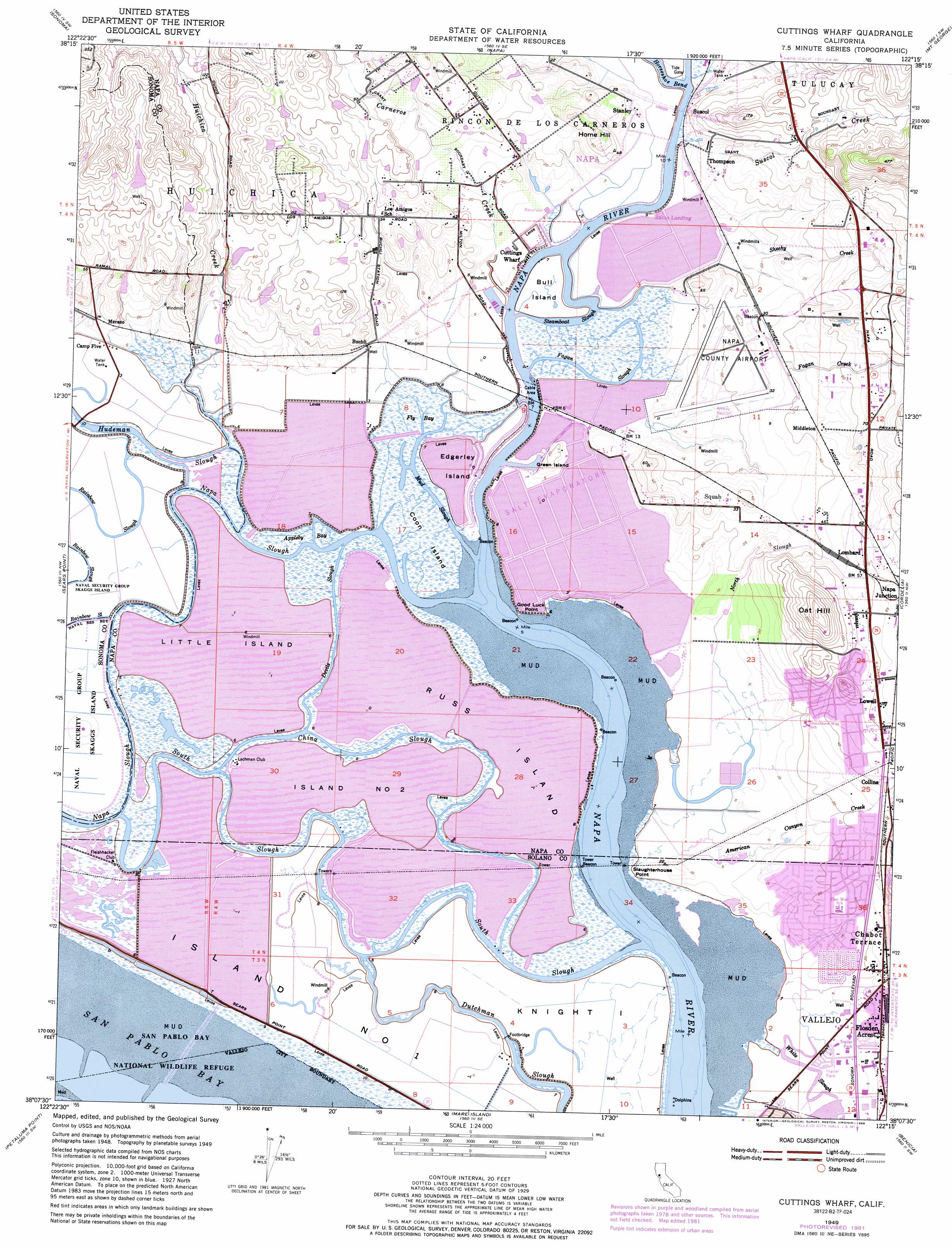
USGS Topo Quad 38122b3 - 1:24,000 scale
| Topo Map Name: | Cuttings Wharf |
| USGS Topo Quad ID: | 38122b3 |
| Print Size: | ca. 21 1/4" wide x 27" high |
| Southeast Coordinates: | 38.125° N latitude / 122.25° W longitude |
| Map Center Coordinates: | 38.1875° N latitude / 122.3125° W longitude |
| U.S. State: | CA |
| Filename: | o38122b3.jpg |
| Download Map JPG Image: | Cuttings Wharf topo map 1:24,000 scale |
| Map Type: | Topographic |
| Topo Series: | 7.5´ |
| Map Scale: | 1:24,000 |
| Source of Map Images: | United States Geological Survey (USGS) |
| Alternate Map Versions: |
Cuttings Wharf CA 1949, updated 1956 Download PDF Buy paper map Cuttings Wharf CA 1949, updated 1969 Download PDF Buy paper map Cuttings Wharf CA 1949, updated 1969 Download PDF Buy paper map Cuttings Wharf CA 1949, updated 1978 Download PDF Buy paper map Cuttings Wharf CA 1949, updated 1981 Download PDF Buy paper map Cuttings Wharf CA 1949, updated 1981 Download PDF Buy paper map Cuttings Wharf CA 1949, updated 1988 Download PDF Buy paper map Cuttings Wharf CA 1949, updated 1988 Download PDF Buy paper map Cuttings Wharf CA 1951 Download PDF Buy paper map Cuttings Wharf CA 2012 Download PDF Buy paper map Cuttings Wharf CA 2015 Download PDF Buy paper map |
1:24,000 Topo Quads surrounding Cuttings Wharf
Kenwood |
Rutherford |
Yountville |
Capell Valley |
Mount Vaca |
Glen Ellen |
Sonoma |
Napa |
Mount George |
Fairfield North |
Petaluma River |
Sears Point |
Cuttings Wharf |
Cordelia |
Fairfield South |
Novato |
Petaluma Point |
Mare Island |
Benicia |
Vine Hill |
San Rafael |
San Quentin |
Richmond |
Briones Valley |
Walnut Creek |
> Back to 38122a1 at 1:100,000 scale
> Back to 38122a1 at 1:250,000 scale
> Back to U.S. Topo Maps home
Cuttings Wharf topo map: Gazetteer
Cuttings Wharf: Airports
Napa County Airport elevation 3m 9′Cuttings Wharf: Capes
Good Luck Point elevation 1m 3′Slaughterhouse Point elevation 1m 3′
Cuttings Wharf: Dams
Buena Vista Winery 4422 Dam elevation 10m 32′Cuttings Wharf: Guts
China Slough elevation 1m 3′Devils Slough elevation 1m 3′
Dutchman Slough elevation 1m 3′
Hudeman Slough elevation 1m 3′
Mud Slough elevation 1m 3′
Napa Slough elevation 1m 3′
South Slough elevation 1m 3′
Steamboat Slough elevation 1m 3′
White Slough elevation 1m 3′
Cuttings Wharf: Islands
Bull Island elevation 1m 3′Coon Island elevation 1m 3′
Edgerley Island elevation 1m 3′
Green Island elevation 7m 22′
Island Number One elevation 1m 3′
Island Number Two elevation 1m 3′
Knight Island elevation 1m 3′
Little Island elevation 1m 3′
Russ Island elevation 1m 3′
Cuttings Wharf: Parks
Henry Ranch Park elevation 4m 13′Meadows Park elevation 2m 6′
Cuttings Wharf: Populated Places
American Canyon elevation 14m 45′Brazos elevation 1m 3′
Buchli elevation 5m 16′
Carneros (historical) elevation 2m 6′
Collins elevation 15m 49′
Cuttings Wharf elevation 2m 6′
Flosden (historical) elevation 10m 32′
Flosden Acres elevation 5m 16′
Lombard elevation 19m 62′
Lowell elevation 20m 65′
Merazo elevation 4m 13′
Middleton elevation 16m 52′
Napa Junction elevation 24m 78′
Ratto Landing elevation 1m 3′
Squab elevation 10m 32′
Stanley elevation 6m 19′
Suscol elevation 1m 3′
Thompson elevation 3m 9′
Cuttings Wharf: Streams
American Canyon Creek elevation 1m 3′Carneros Creek elevation 1m 3′
Fagan Creek elevation 1m 3′
Fagan Slough elevation 1m 3′
Huichica Creek elevation 1m 3′
North Slough elevation 1m 3′
Sheehy Creek elevation 2m 6′
Suscol Creek elevation 1m 3′
Cuttings Wharf: Summits
Home Hill elevation 22m 72′Oat Hill elevation 80m 262′
Cuttings Wharf: Swamps
Appleby Bay elevation 1m 3′Fly Bay elevation 1m 3′
Cuttings Wharf digital topo map on disk
Buy this Cuttings Wharf topo map showing relief, roads, GPS coordinates and other geographical features, as a high-resolution digital map file on DVD: