Mount George Topo Map California
To zoom in, hover over the map of Mount George
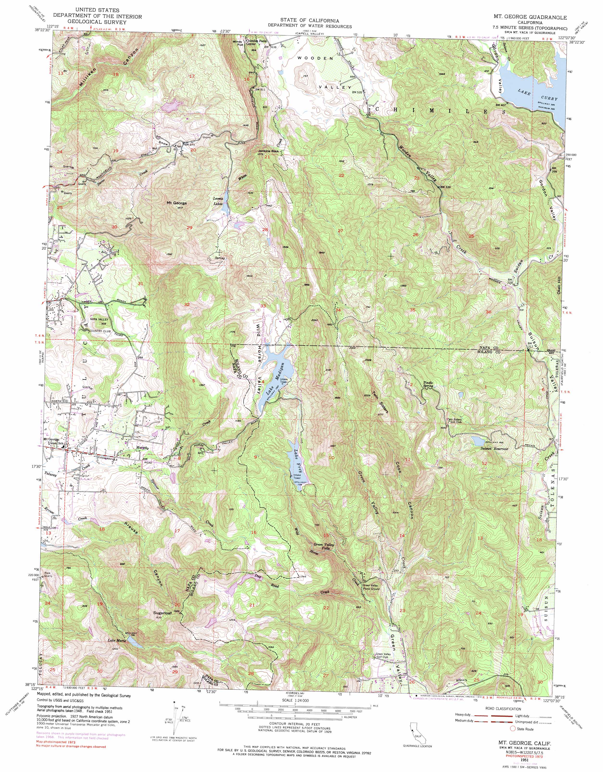
USGS Topo Quad 38122c2 - 1:24,000 scale
| Topo Map Name: | Mount George |
| USGS Topo Quad ID: | 38122c2 |
| Print Size: | ca. 21 1/4" wide x 27" high |
| Southeast Coordinates: | 38.25° N latitude / 122.125° W longitude |
| Map Center Coordinates: | 38.3125° N latitude / 122.1875° W longitude |
| U.S. State: | CA |
| Filename: | o38122c2.jpg |
| Download Map JPG Image: | Mount George topo map 1:24,000 scale |
| Map Type: | Topographic |
| Topo Series: | 7.5´ |
| Map Scale: | 1:24,000 |
| Source of Map Images: | United States Geological Survey (USGS) |
| Alternate Map Versions: |
Mt. George CA 1951, updated 1952 Download PDF Buy paper map Mt. George CA 1951, updated 1957 Download PDF Buy paper map Mt. George CA 1951, updated 1969 Download PDF Buy paper map Mt. George CA 1951, updated 1978 Download PDF Buy paper map Mt. George CA 1951, updated 1978 Download PDF Buy paper map Mount George CA 2012 Download PDF Buy paper map Mount George CA 2015 Download PDF Buy paper map |
1:24,000 Topo Quads surrounding Mount George
Saint Helena |
Chiles Valley |
Lake Berryessa |
Monticello Dam |
Winters |
Rutherford |
Yountville |
Capell Valley |
Mount Vaca |
Allendale |
Sonoma |
Napa |
Mount George |
Fairfield North |
Elmira |
Sears Point |
Cuttings Wharf |
Cordelia |
Fairfield South |
Denverton |
Petaluma Point |
Mare Island |
Benicia |
Vine Hill |
Honker Bay |
> Back to 38122a1 at 1:100,000 scale
> Back to 38122a1 at 1:250,000 scale
> Back to U.S. Topo Maps home
Mount George topo map: Gazetteer
Mount George: Dams
B J Robinson 2410 Dam elevation 126m 413′Green Valley Lake 447 Dam elevation 335m 1099′
Lake Madigan 14-002 Dam elevation 416m 1364′
Lake Marie 1-006 Dam elevation 245m 803′
Municipal 21 Dam elevation 243m 797′
Thompson 2411 Dam elevation 82m 269′
Timberhill Lake 419 Dam elevation 318m 1043′
Mount George: Falls
Green Valley Falls elevation 140m 459′Mount George: Flats
Snow Flat elevation 287m 941′Wind Flat elevation 253m 830′
Mount George: Lakes
Leoma Lakes elevation 406m 1332′Mount George: Pillars
Jenkins Rock elevation 354m 1161′Mount George: Populated Places
Green Valley elevation 35m 114′Mount George: Reservoirs
Lake Frey elevation 366m 1200′Lake Madigan elevation 416m 1364′
Lake Marie elevation 245m 803′
Suisun Reservoir elevation 243m 797′
Mount George: Springs
Tindle Spring elevation 352m 1154′Mount George: Streams
Dug Road Creek elevation 68m 223′Murphy Creek elevation 34m 111′
Spencer Creek elevation 34m 111′
White Creek elevation 139m 456′
Wild Horse Creek elevation 45m 147′
Wooden Valley Creek elevation 67m 219′
Mount George: Summits
Mount George elevation 572m 1876′Sugarloaf elevation 499m 1637′
Twin Sisters elevation 659m 2162′
Mount George: Valleys
Cook Canyon elevation 129m 423′Gordon Valley elevation 77m 252′
Kreuse Canyon elevation 56m 183′
Wild Horse Valley elevation 426m 1397′
Wooden Valley elevation 155m 508′
Mount George digital topo map on disk
Buy this Mount George topo map showing relief, roads, GPS coordinates and other geographical features, as a high-resolution digital map file on DVD: