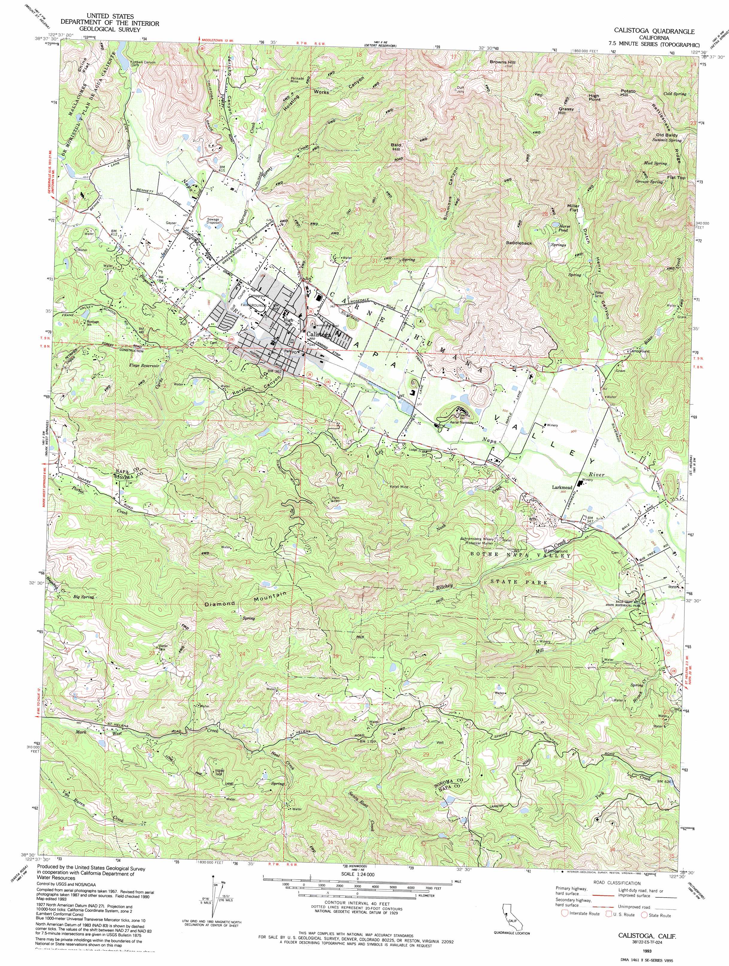
Calistoga Topo Map California
To zoom in, hover over the map of Calistoga
USGS Topo Quad 38122e5 - 1:24,000 scale
| Topo Map Name: | Calistoga |
| USGS Topo Quad ID: | 38122e5 |
| Print Size: | ca. 21 1/4" wide x 27" high |
| Southeast Coordinates: | 38.5° N latitude / 122.5° W longitude |
| Map Center Coordinates: | 38.5625° N latitude / 122.5625° W longitude |
| U.S. State: | CA |
| Filename: | o38122e5.jpg |
| Download Map JPG Image: | Calistoga topo map 1:24,000 scale |
| Map Type: | Topographic |
| Topo Series: | 7.5´ |
| Map Scale: | 1:24,000 |
| Source of Map Images: | United States Geological Survey (USGS) |
| Alternate Map Versions: |
Calistoga CA 1958, updated 1961 Download PDF Buy paper map Calistoga CA 1958, updated 1965 Download PDF Buy paper map Calistoga CA 1958, updated 1965 Download PDF Buy paper map Calistoga CA 1958, updated 1980 Download PDF Buy paper map Calistoga CA 1958, updated 1980 Download PDF Buy paper map Calistoga CA 1993, updated 1993 Download PDF Buy paper map Calistoga CA 1997, updated 1998 Download PDF Buy paper map Calistoga CA 2012 Download PDF Buy paper map Calistoga CA 2015 Download PDF Buy paper map |
1:24,000 Topo Quads surrounding Calistoga
The Geysers |
Whispering Pines |
Middletown |
Jericho Valley |
Knoxville |
Jimtown |
Mount Saint Helena |
Detert Reservoir |
Aetna Springs |
Walter Springs |
Healdsburg |
Mark West Springs |
Calistoga |
Saint Helena |
Chiles Valley |
Sebastopol |
Santa Rosa |
Kenwood |
Rutherford |
Yountville |
Two Rock |
Cotati |
Glen Ellen |
Sonoma |
Napa |
> Back to 38122e1 at 1:100,000 scale
> Back to 38122a1 at 1:250,000 scale
> Back to U.S. Topo Maps home
Calistoga topo map: Gazetteer
Calistoga: Airports
Calistoga Gliderport (historical) elevation 105m 344′Calistoga: Dams
Kimball Canyon Dam elevation 178m 583′Kimball Creek 83 Dam elevation 187m 613′
Saint Helena Upper 16 Dam elevation 189m 620′
Calistoga: Flats
Chino Flat elevation 319m 1046′Miller Flat elevation 243m 797′
Calistoga: Gaps
Saddleback elevation 515m 1689′Calistoga: Lakes
Horse Pond elevation 364m 1194′Calistoga: Mines
Kellet Mine elevation 183m 600′Palisade Mine elevation 196m 643′
Calistoga: Parks
Bale Grist Mill State Historic Park elevation 109m 357′Bothe-Napa Valley State Park elevation 198m 649′
Pioneer Park elevation 105m 344′
Schramsberg Winery Historical Marker elevation 202m 662′
Calistoga: Populated Places
Bale elevation 86m 282′Calistoga elevation 106m 347′
Larkmead elevation 89m 291′
Woodleaf elevation 119m 390′
Calistoga: Post Offices
Calistoga Post Office elevation 105m 344′Calistoga: Reservoirs
Fiege Reservoir elevation 144m 472′Calistoga: Springs
Big Spring elevation 493m 1617′Cold Spring elevation 581m 1906′
Grouse Spring elevation 676m 2217′
Mud Spring elevation 720m 2362′
Old Faithful Geyser of California elevation 124m 406′
Summit Spring elevation 836m 2742′
Calistoga: Streams
Biter Creek elevation 79m 259′Blossom Creek elevation 112m 367′
Cyrus Creek elevation 111m 364′
Garnett Creek elevation 110m 360′
Hirsch Creek elevation 109m 357′
Horns Creek elevation 123m 403′
Nash Creek elevation 87m 285′
Neal Creek elevation 438m 1437′
Ritchey Creek elevation 80m 262′
Calistoga: Summits
Bald Hill elevation 508m 1666′Browns Hill elevation 825m 2706′
Coyote Peak elevation 345m 1131′
Diamond Mountain elevation 716m 2349′
Flat Top elevation 832m 2729′
Grassy Hill elevation 736m 2414′
High Point elevation 824m 2703′
Old Baldy elevation 836m 2742′
Potato Hill elevation 771m 2529′
Calistoga: Trails
Coyote Peak Trail elevation 293m 961′Redwood Trail elevation 159m 521′
Ritchey Canyon Trail elevation 173m 567′
South Fork Trail elevation 301m 987′
Spring Trail elevation 323m 1059′
Upper Ritchey Canyon Trail elevation 330m 1082′
Calistoga: Valleys
Dutch Henry Canyon elevation 107m 351′Hoisting Works Canyon elevation 168m 551′
Jericho Canyon elevation 143m 469′
Kortum Canyon elevation 105m 344′
Simmons Canyon elevation 111m 364′
Calistoga digital topo map on disk
Buy this Calistoga topo map showing relief, roads, GPS coordinates and other geographical features, as a high-resolution digital map file on DVD: