Healdsburg Topo Map California
To zoom in, hover over the map of Healdsburg
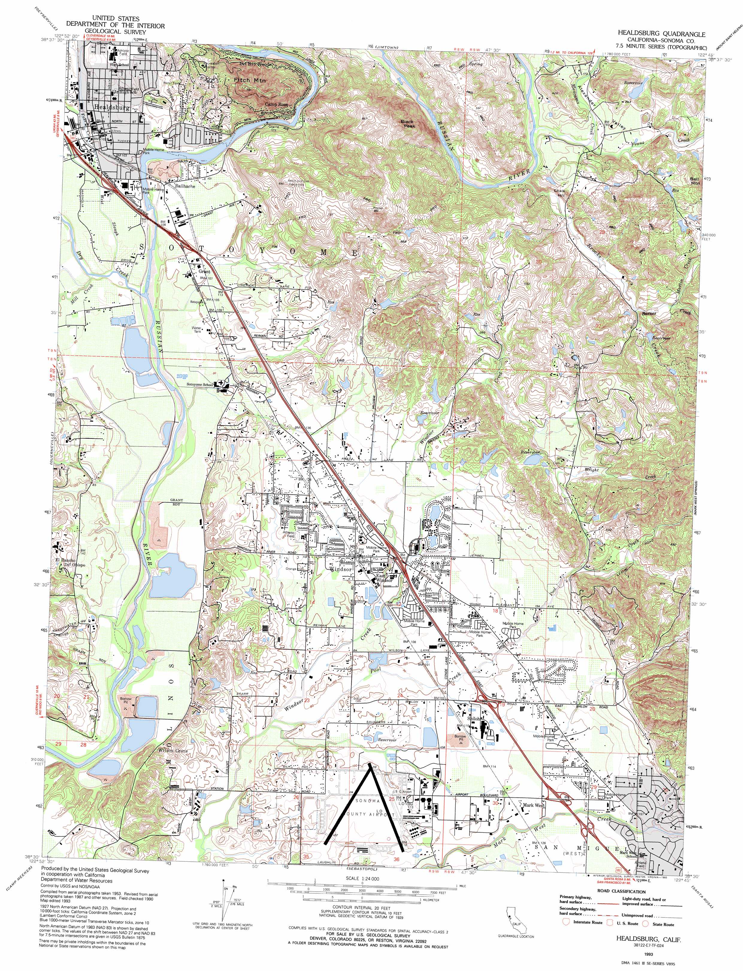
USGS Topo Quad 38122e7 - 1:24,000 scale
| Topo Map Name: | Healdsburg |
| USGS Topo Quad ID: | 38122e7 |
| Print Size: | ca. 21 1/4" wide x 27" high |
| Southeast Coordinates: | 38.5° N latitude / 122.75° W longitude |
| Map Center Coordinates: | 38.5625° N latitude / 122.8125° W longitude |
| U.S. State: | CA |
| Filename: | o38122e7.jpg |
| Download Map JPG Image: | Healdsburg topo map 1:24,000 scale |
| Map Type: | Topographic |
| Topo Series: | 7.5´ |
| Map Scale: | 1:24,000 |
| Source of Map Images: | United States Geological Survey (USGS) |
| Alternate Map Versions: |
Healdsburg CA 1955, updated 1956 Download PDF Buy paper map Healdsburg CA 1955, updated 1956 Download PDF Buy paper map Healdsburg CA 1955, updated 1980 Download PDF Buy paper map Healdsburg CA 1993, updated 1993 Download PDF Buy paper map Healdsburg CA 2012 Download PDF Buy paper map Healdsburg CA 2015 Download PDF Buy paper map |
1:24,000 Topo Quads surrounding Healdsburg
Cloverdale |
Asti |
The Geysers |
Whispering Pines |
Middletown |
Warm Springs Dam |
Geyserville |
Jimtown |
Mount Saint Helena |
Detert Reservoir |
Cazadero |
Guerneville |
Healdsburg |
Mark West Springs |
Calistoga |
Duncans Mills |
Camp Meeker |
Sebastopol |
Santa Rosa |
Kenwood |
Bodega Head |
Valley Ford |
Two Rock |
Cotati |
Glen Ellen |
> Back to 38122e1 at 1:100,000 scale
> Back to 38122a1 at 1:250,000 scale
> Back to U.S. Topo Maps home
Healdsburg topo map: Gazetteer
Healdsburg: Airports
Allan Ranch Flight Park Ultralight elevation 59m 193′Sonoma County Airport elevation 36m 118′
Healdsburg: Beaches
Healdsburg Veterans Memorial Beach elevation 24m 78′Healdsburg: Dams
Axell 421 Dam elevation 89m 291′Donovan 1422 Dam elevation 126m 413′
Greeott 420 Dam elevation 107m 351′
Healdsburg Rec 1002 Dam elevation 24m 78′
Lagunita 1427 Dam elevation 71m 232′
Lowe 2427 Dam elevation 138m 452′
Refvem Number 1 3421 Dam elevation 100m 328′
Healdsburg: Parks
Esposti Park elevation 42m 137′Giorgi Park elevation 39m 127′
Healdsburg Plaza elevation 32m 104′
Healdsburg Recreation Park elevation 37m 121′
Healdsburg Veterans Memorial Beach Park elevation 30m 98′
Keiser Community Park elevation 32m 104′
Lakewood Meadows Park elevation 38m 124′
Las Robles Park elevation 47m 154′
Pleasant Avenue Park elevation 40m 131′
Robbie Way Park elevation 41m 134′
Robbins Park elevation 39m 127′
Shiloh Ranch Regional Park elevation 154m 505′
Tayman Park elevation 60m 196′
Healdsburg: Populated Places
Bailhache elevation 31m 101′Camp Rose elevation 35m 114′
Del Rio Woods elevation 41m 134′
East Windsor elevation 37m 121′
Grant elevation 32m 104′
Healdsburg elevation 32m 104′
Shiloh elevation 34m 111′
Wikiup elevation 59m 193′
Wilson Grove elevation 23m 75′
Windsor elevation 36m 118′
Healdsburg: Post Offices
Healdsburg Post Office elevation 33m 108′Windsor Post Office elevation 37m 121′
Healdsburg: Streams
Barnes Creek elevation 67m 219′Brooks Creek elevation 41m 134′
Dry Creek elevation 25m 82′
Foss Creek elevation 31m 101′
Franz Creek elevation 43m 141′
Maacama Creek elevation 43m 141′
Martin Creek elevation 72m 236′
Mill Creek elevation 22m 72′
Norton Slough elevation 36m 118′
Pool Creek elevation 21m 68′
West Slough elevation 25m 82′
Wright Creek elevation 56m 183′
Healdsburg: Summits
Bell Mountain elevation 193m 633′Black Peak elevation 282m 925′
Chalk Hill elevation 84m 275′
Fitch Mountain elevation 302m 990′
Healdsburg: Valleys
Alexander Valley elevation 58m 190′Healdsburg: Woods
Adam and Eve Redwoods elevation 192m 629′Healdsburg digital topo map on disk
Buy this Healdsburg topo map showing relief, roads, GPS coordinates and other geographical features, as a high-resolution digital map file on DVD: