Jimtown Topo Map California
To zoom in, hover over the map of Jimtown
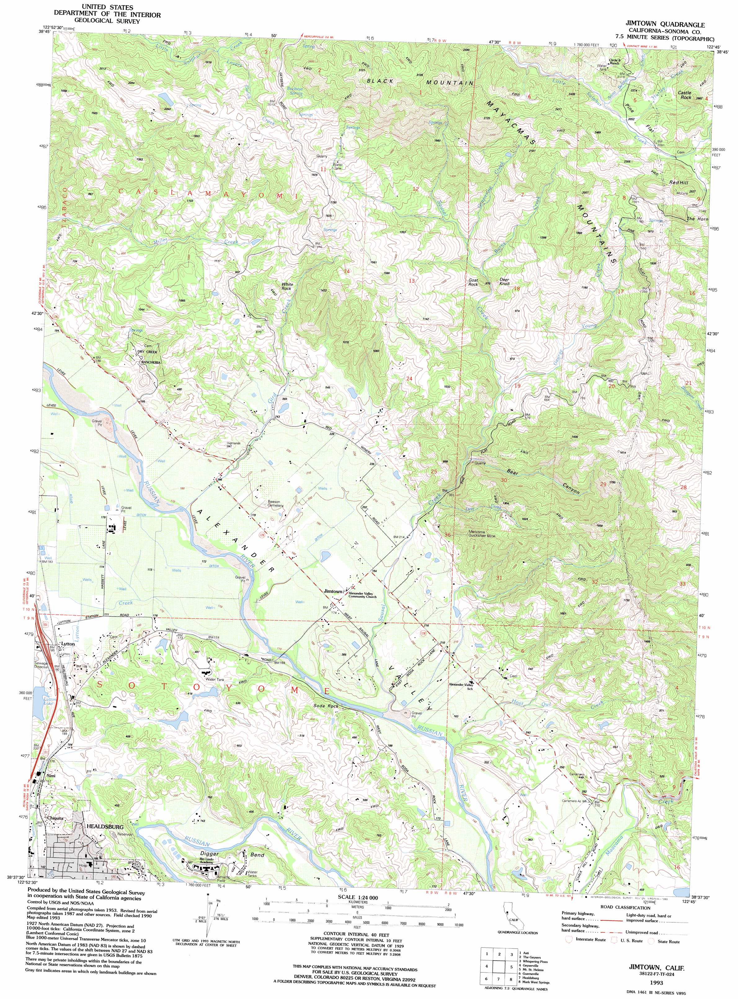
USGS Topo Quad 38122f7 - 1:24,000 scale
| Topo Map Name: | Jimtown |
| USGS Topo Quad ID: | 38122f7 |
| Print Size: | ca. 21 1/4" wide x 27" high |
| Southeast Coordinates: | 38.625° N latitude / 122.75° W longitude |
| Map Center Coordinates: | 38.6875° N latitude / 122.8125° W longitude |
| U.S. State: | CA |
| Filename: | o38122f7.jpg |
| Download Map JPG Image: | Jimtown topo map 1:24,000 scale |
| Map Type: | Topographic |
| Topo Series: | 7.5´ |
| Map Scale: | 1:24,000 |
| Source of Map Images: | United States Geological Survey (USGS) |
| Alternate Map Versions: |
Jimtown CA 1955, updated 1956 Download PDF Buy paper map Jimtown CA 1955, updated 1965 Download PDF Buy paper map Jimtown CA 1955, updated 1976 Download PDF Buy paper map Jimtown CA 1955, updated 1978 Download PDF Buy paper map Jimtown CA 1993, updated 1993 Download PDF Buy paper map Jimtown CA 2012 Download PDF Buy paper map Jimtown CA 2015 Download PDF Buy paper map |
1:24,000 Topo Quads surrounding Jimtown
Hopland |
Highland Springs |
Kelseyville |
Clearlake |
Lower Lake |
Cloverdale |
Asti |
The Geysers |
Whispering Pines |
Middletown |
Warm Springs Dam |
Geyserville |
Jimtown |
Mount Saint Helena |
Detert Reservoir |
Cazadero |
Guerneville |
Healdsburg |
Mark West Springs |
Calistoga |
Duncans Mills |
Camp Meeker |
Sebastopol |
Santa Rosa |
Kenwood |
> Back to 38122e1 at 1:100,000 scale
> Back to 38122a1 at 1:250,000 scale
> Back to U.S. Topo Maps home
Jimtown topo map: Gazetteer
Jimtown: Bends
Digger Bend elevation 57m 187′Jimtown: Capes
The Horn elevation 651m 2135′Jimtown: Dams
Budge 3423 Dam elevation 95m 311′Lytton 2424 Dam elevation 65m 213′
Jimtown: Flats
Pine Flat elevation 659m 2162′Jimtown: Lakes
Lytton Lake elevation 66m 216′Jimtown: Mines
Mericoma Quicksilver Mine elevation 248m 813′Jimtown: Parks
Gibbs Park elevation 59m 193′Jimtown: Pillars
Goat Rock elevation 241m 790′Soda Rock elevation 46m 150′
White Rock elevation 312m 1023′
Jimtown: Populated Places
Chiquita elevation 48m 157′Jimtown elevation 55m 180′
Lytton elevation 56m 183′
Simi elevation 58m 190′
Jimtown: Post Offices
Alexander Valley Post Office (historical) elevation 55m 180′Jimtown: Springs
Buckeye Spring elevation 694m 2276′Jimtown: Streams
Anna Belcher Creek elevation 619m 2030′Burns Creek elevation 181m 593′
Deer Creek elevation 72m 236′
George Young Creek elevation 109m 357′
Gird Creek elevation 53m 173′
Grapevine Creek elevation 215m 705′
Hoot Owl Creek elevation 46m 150′
Hurley Creek elevation 626m 2053′
Lovers Gulch Creek elevation 445m 1459′
Lytton Creek elevation 49m 160′
Sausal Creek elevation 46m 150′
Jimtown: Summits
Black Mountain elevation 950m 3116′Castle Rock elevation 804m 2637′
Deer Knoll elevation 243m 797′
Red Hill elevation 768m 2519′
Jimtown: Valleys
Bear Canyon elevation 101m 331′Jimtown digital topo map on disk
Buy this Jimtown topo map showing relief, roads, GPS coordinates and other geographical features, as a high-resolution digital map file on DVD: