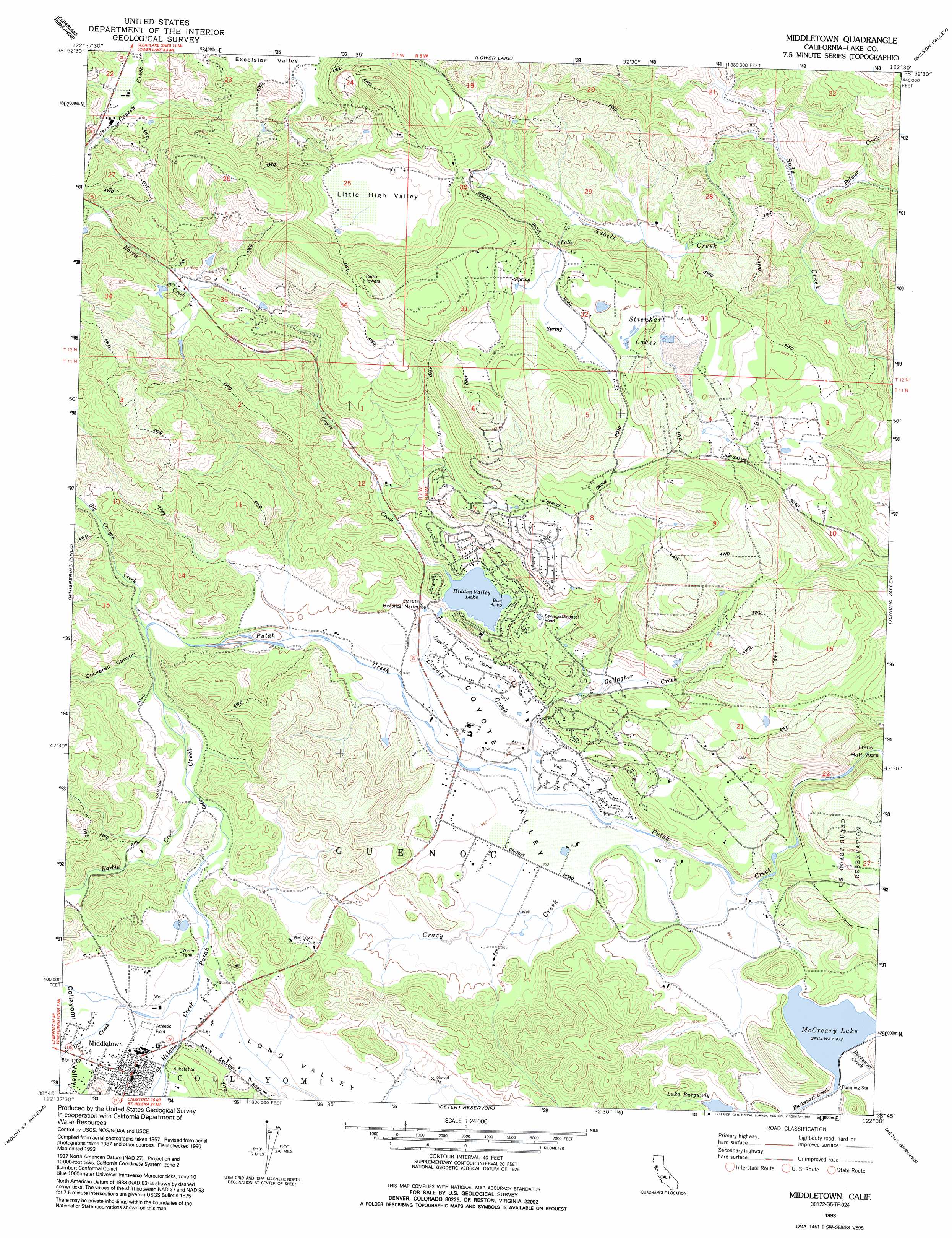
Middletown Topo Map California
To zoom in, hover over the map of Middletown
USGS Topo Quad 38122g5 - 1:24,000 scale
| Topo Map Name: | Middletown |
| USGS Topo Quad ID: | 38122g5 |
| Print Size: | ca. 21 1/4" wide x 27" high |
| Southeast Coordinates: | 38.75° N latitude / 122.5° W longitude |
| Map Center Coordinates: | 38.8125° N latitude / 122.5625° W longitude |
| U.S. State: | CA |
| Filename: | o38122g5.jpg |
| Download Map JPG Image: | Middletown topo map 1:24,000 scale |
| Map Type: | Topographic |
| Topo Series: | 7.5´ |
| Map Scale: | 1:24,000 |
| Source of Map Images: | United States Geological Survey (USGS) |
| Alternate Map Versions: |
Middletown CA 1958, updated 1961 Download PDF Buy paper map Middletown CA 1958, updated 1967 Download PDF Buy paper map Middletown CA 1958, updated 1991 Download PDF Buy paper map Middletown CA 1993, updated 1993 Download PDF Buy paper map Middletown CA 1998, updated 2002 Download PDF Buy paper map Middletown CA 2012 Download PDF Buy paper map Middletown CA 2015 Download PDF Buy paper map |
1:24,000 Topo Quads surrounding Middletown
Lucerne |
Clearlake Oaks |
Benmore Canyon |
Wilbur Springs |
Salt Canyon |
Kelseyville |
Clearlake |
Lower Lake |
Wilson Valley |
Glascock Mountain |
The Geysers |
Whispering Pines |
Middletown |
Jericho Valley |
Knoxville |
Jimtown |
Mount Saint Helena |
Detert Reservoir |
Aetna Springs |
Walter Springs |
Healdsburg |
Mark West Springs |
Calistoga |
Saint Helena |
Chiles Valley |
> Back to 38122e1 at 1:100,000 scale
> Back to 38122a1 at 1:250,000 scale
> Back to U.S. Topo Maps home
Middletown topo map: Gazetteer
Middletown: Dams
Coyote Creek 397 Dam elevation 338m 1108′McCreary 392-002 Dam elevation 296m 971′
Middletown: Lakes
Lake Burgundy elevation 302m 990′Stienhart Lakes elevation 545m 1788′
Middletown: Populated Places
Guenoc (historical) elevation 295m 967′Hidden Valley Lake elevation 363m 1190′
Middletown elevation 335m 1099′
Middletown: Post Offices
Middletown Post Office elevation 338m 1108′Middletown: Reservoirs
Hidden Valley Lake elevation 333m 1092′McCreary Lake elevation 296m 971′
Middletown: Streams
Asbill Creek elevation 330m 1082′Big Canyon Creek elevation 314m 1030′
Coyote Creek elevation 285m 935′
Crazy Creek elevation 278m 912′
Dry Creek elevation 330m 1082′
Gallagher Creek elevation 293m 961′
Harbin Creek elevation 327m 1072′
Palmer Creek elevation 322m 1056′
Saint Helena Creek elevation 328m 1076′
Middletown: Valleys
Cockerell Canyon elevation 316m 1036′Coyote Valley elevation 304m 997′
Little High Valley elevation 521m 1709′
Long Valley elevation 330m 1082′
Middletown digital topo map on disk
Buy this Middletown topo map showing relief, roads, GPS coordinates and other geographical features, as a high-resolution digital map file on DVD: