Lower Lake Topo Map California
To zoom in, hover over the map of Lower Lake
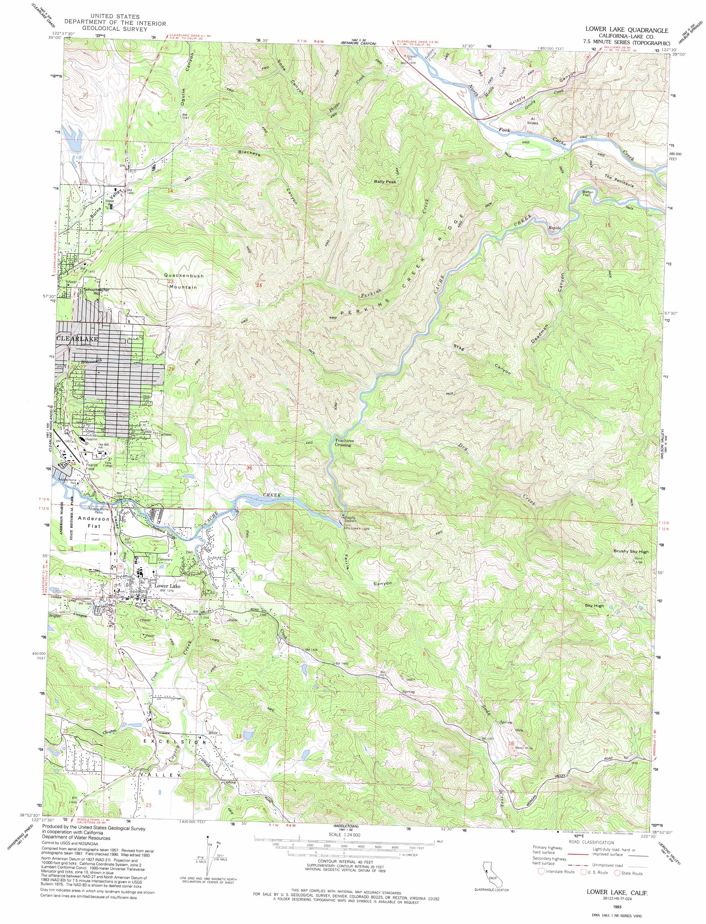
USGS Topo Quad 38122h5 - 1:24,000 scale
| Topo Map Name: | Lower Lake |
| USGS Topo Quad ID: | 38122h5 |
| Print Size: | ca. 21 1/4" wide x 27" high |
| Southeast Coordinates: | 38.875° N latitude / 122.5° W longitude |
| Map Center Coordinates: | 38.9375° N latitude / 122.5625° W longitude |
| U.S. State: | CA |
| Filename: | o38122h5.jpg |
| Download Map JPG Image: | Lower Lake topo map 1:24,000 scale |
| Map Type: | Topographic |
| Topo Series: | 7.5´ |
| Map Scale: | 1:24,000 |
| Source of Map Images: | United States Geological Survey (USGS) |
| Alternate Map Versions: |
Lower Lake CA 1958, updated 1961 Download PDF Buy paper map Lower Lake CA 1958, updated 1966 Download PDF Buy paper map Lower Lake CA 1958, updated 1969 Download PDF Buy paper map Lower Lake CA 1958, updated 1978 Download PDF Buy paper map Lower Lake CA 1958, updated 1987 Download PDF Buy paper map Lower Lake CA 1977, updated 1980 Download PDF Buy paper map Lower Lake CA 1993, updated 1993 Download PDF Buy paper map Lower Lake CA 1993, updated 1993 Download PDF Buy paper map Lower Lake CA 2012 Download PDF Buy paper map Lower Lake CA 2015 Download PDF Buy paper map |
1:24,000 Topo Quads surrounding Lower Lake
Bartlett Mountain |
Bartlett Springs |
Hough Springs |
Leesville |
Manor Slough |
Lucerne |
Clearlake Oaks |
Benmore Canyon |
Wilbur Springs |
Salt Canyon |
Kelseyville |
Clearlake |
Lower Lake |
Wilson Valley |
Glascock Mountain |
The Geysers |
Whispering Pines |
Middletown |
Jericho Valley |
Knoxville |
Jimtown |
Mount Saint Helena |
Detert Reservoir |
Aetna Springs |
Walter Springs |
> Back to 38122e1 at 1:100,000 scale
> Back to 38122a1 at 1:250,000 scale
> Back to U.S. Topo Maps home
Lower Lake topo map: Gazetteer
Lower Lake: Airports
Pearce Airport elevation 422m 1384′Pearce Field (historical) elevation 420m 1377′
Lower Lake: Basins
Excelsior Valley elevation 431m 1414′Lower Lake: Capes
The Peninsula elevation 389m 1276′Lower Lake: Dams
Clear Lake Imp 1080 Dam elevation 403m 1322′Clear Lake Water Company Dam elevation 406m 1332′
Lake Company Sanitation District 1081 Dam elevation 429m 1407′
Lower Lake: Flats
Anderson Flat elevation 408m 1338′Baton Flat elevation 311m 1020′
Lower Lake: Mines
Baker Mine elevation 431m 1414′Weiper Mine elevation 439m 1440′
Lower Lake: Parks
Lower Lake Schoolhouse Historic Site elevation 426m 1397′Lower Lake: Populated Places
Lower Lake elevation 418m 1371′Twin Lakes elevation 437m 1433′
Lower Lake: Post Offices
Lower Lake Post Office elevation 420m 1377′Lower Lake: Reservoirs
Clear Lake elevation 403m 1322′Lower Lake: Ridges
Perkins Creek Ridge elevation 547m 1794′Lower Lake: Slopes
Al Slides elevation 331m 1085′Lower Lake: Streams
Clayton Creek elevation 414m 1358′Copsey Creek elevation 408m 1338′
Dry Creek elevation 380m 1246′
Grizzly Creek elevation 302m 990′
Herndon Creek elevation 407m 1335′
Indian Creek elevation 310m 1017′
Middle Creek elevation 302m 990′
North Fork Cache Creek elevation 287m 941′
Perkins Creek elevation 295m 967′
Phipps Creek elevation 310m 1017′
Seigler Canyon Creek elevation 408m 1338′
Lower Lake: Summits
Bally Peak elevation 678m 2224′Brushy Sky High elevation 968m 3175′
Quackenbush Mountain elevation 649m 2129′
Schoolteacher Hill elevation 511m 1676′
Sky High elevation 859m 2818′
Lower Lake: Trails
Anderson Flats Trail elevation 404m 1325′Cache Creek Trail elevation 404m 1325′
McVicar Trail elevation 417m 1368′
Lower Lake: Valleys
Blackeye Canyon elevation 437m 1433′Deadman Canyon elevation 327m 1072′
Ferris Canyon elevation 413m 1354′
Grizzly Canyon elevation 321m 1053′
Ogulin Canyon elevation 437m 1433′
Redbank Gorge elevation 409m 1341′
Soda Canyon elevation 393m 1289′
Stag Canyon elevation 365m 1197′
Lower Lake digital topo map on disk
Buy this Lower Lake topo map showing relief, roads, GPS coordinates and other geographical features, as a high-resolution digital map file on DVD: