Kelseyville Topo Map California
To zoom in, hover over the map of Kelseyville
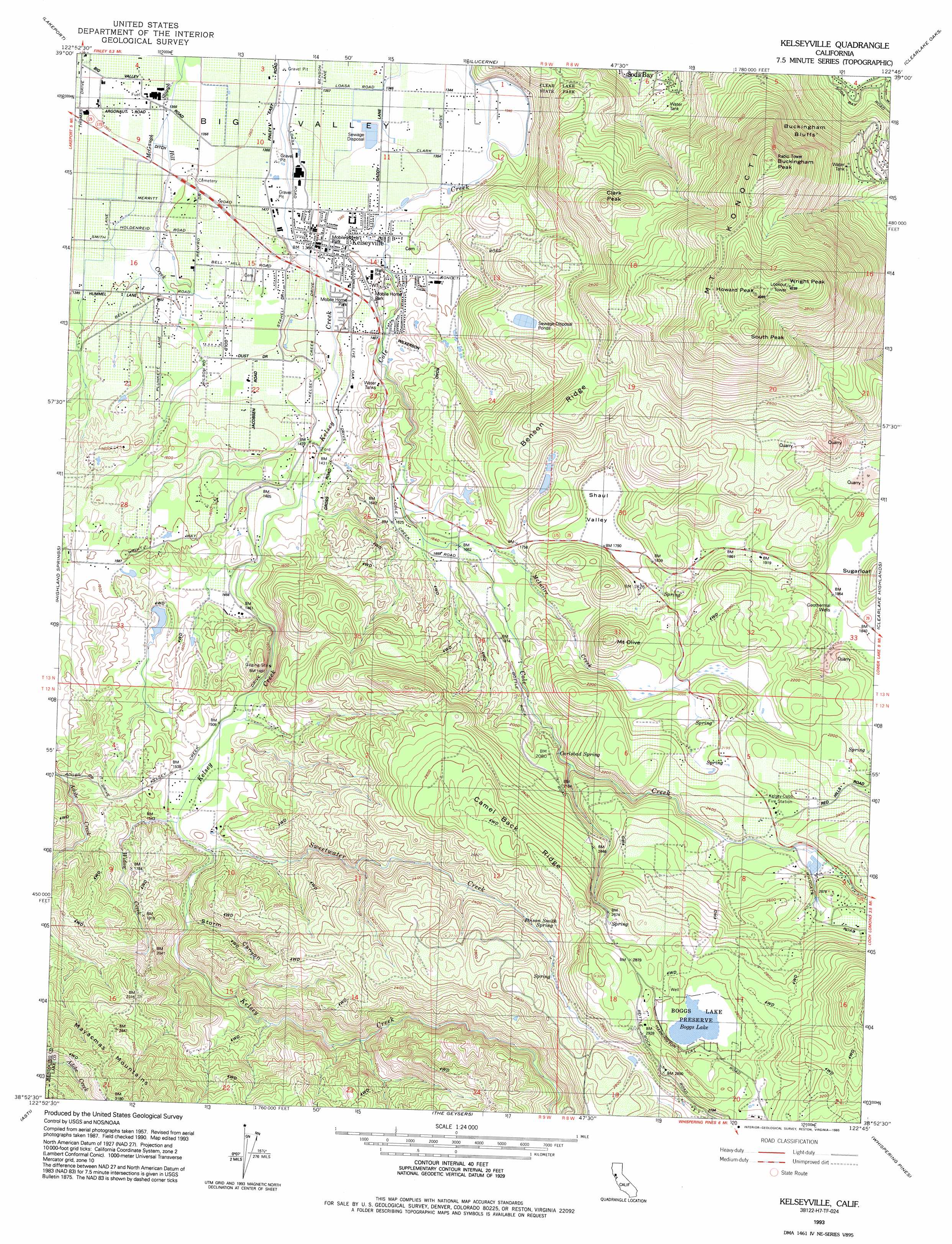
USGS Topo Quad 38122h7 - 1:24,000 scale
| Topo Map Name: | Kelseyville |
| USGS Topo Quad ID: | 38122h7 |
| Print Size: | ca. 21 1/4" wide x 27" high |
| Southeast Coordinates: | 38.875° N latitude / 122.75° W longitude |
| Map Center Coordinates: | 38.9375° N latitude / 122.8125° W longitude |
| U.S. State: | CA |
| Filename: | o38122h7.jpg |
| Download Map JPG Image: | Kelseyville topo map 1:24,000 scale |
| Map Type: | Topographic |
| Topo Series: | 7.5´ |
| Map Scale: | 1:24,000 |
| Source of Map Images: | United States Geological Survey (USGS) |
| Alternate Map Versions: |
Kelseyville CA 1959, updated 1961 Download PDF Buy paper map Kelseyville CA 1959, updated 1966 Download PDF Buy paper map Kelseyville CA 1959, updated 1978 Download PDF Buy paper map Kelseyville CA 1974, updated 1980 Download PDF Buy paper map Kelseyville CA 1993, updated 1993 Download PDF Buy paper map Kelseyville CA 2012 Download PDF Buy paper map Kelseyville CA 2015 Download PDF Buy paper map |
1:24,000 Topo Quads surrounding Kelseyville
Cow Mountain |
Upper Lake |
Bartlett Mountain |
Bartlett Springs |
Hough Springs |
Purdys Gardens |
Lakeport |
Lucerne |
Clearlake Oaks |
Benmore Canyon |
Hopland |
Highland Springs |
Kelseyville |
Clearlake |
Lower Lake |
Cloverdale |
Asti |
The Geysers |
Whispering Pines |
Middletown |
Warm Springs Dam |
Geyserville |
Jimtown |
Mount Saint Helena |
Detert Reservoir |
> Back to 38122e1 at 1:100,000 scale
> Back to 38122a1 at 1:250,000 scale
> Back to U.S. Topo Maps home
Kelseyville topo map: Gazetteer
Kelseyville: Areas
Big Valley elevation 416m 1364′Kelseyville: Basins
Shaul Valley elevation 534m 1751′Kelseyville: Cliffs
Buckingham Bluffs elevation 713m 2339′Kelseyville: Dams
Allen 394 Dam elevation 464m 1522′Kelseyville: Lakes
Boggs Lake elevation 847m 2778′Kelseyville: Mines
Bell Mine elevation 680m 2230′Kelseyville: Parks
Boggs Lake Preserve elevation 847m 2778′Kelseyville: Populated Places
Glenview elevation 751m 2463′Kelseyville elevation 422m 1384′
Kelseyville: Post Offices
Kelseyville Post Office elevation 422m 1384′Kelseyville: Ridges
Benson Ridge elevation 753m 2470′Camel Back Ridge elevation 862m 2828′
Kelseyville: Springs
Carlsbad Spring elevation 634m 2080′Poison Smith Spring elevation 791m 2595′
Kelseyville: Streams
Hill Creek elevation 415m 1361′McIntire Creek elevation 500m 1640′
Sweetwater Creek elevation 464m 1522′
Widow Creek elevation 462m 1515′
Kelseyville: Summits
Buckingham Peak elevation 1200m 3937′Clark Peak elevation 834m 2736′
Howard Peak elevation 1297m 4255′
Mount Konocti elevation 1307m 4288′
Mount Olive elevation 744m 2440′
South Peak elevation 1236m 4055′
Sugarloaf elevation 661m 2168′
Wright Peak elevation 1310m 4297′
Kelseyville: Valleys
Storm Canyon elevation 483m 1584′Kelseyville digital topo map on disk
Buy this Kelseyville topo map showing relief, roads, GPS coordinates and other geographical features, as a high-resolution digital map file on DVD: