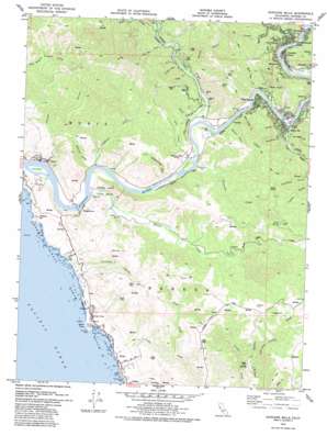
Duncans Mills Topo Map California
To zoom in, hover over the map of Duncans Mills
USGS Topo Quad 38123d1 - 1:24,000 scale
| Topo Map Name: | Duncans Mills |
| USGS Topo Quad ID: | 38123d1 |
| Print Size: | ca. 21 1/4" wide x 27" high |
| Southeast Coordinates: | 38.375° N latitude / 123° W longitude |
| Map Center Coordinates: | 38.4375° N latitude / 123.0625° W longitude |
| U.S. State: | CA |
| Filename: | o38123d1.jpg |
| Download Map JPG Image: | Duncans Mills topo map 1:24,000 scale |
| Map Type: | Topographic |
| Topo Series: | 7.5´ |
| Map Scale: | 1:24,000 |
| Source of Map Images: | United States Geological Survey (USGS) |
| Alternate Map Versions: |
Duncans Mills CA 1943, updated 1956 Download PDF Buy paper map Duncans Mills CA 1943, updated 1964 Download PDF Buy paper map Duncans Mills CA 1952, updated 1980 Download PDF Buy paper map Duncans Mills CA 1979, updated 1979 Download PDF Buy paper map Duncans Mills CA 1979, updated 1983 Download PDF Buy paper map Duncans Mills CA 2012 Download PDF Buy paper map Duncans Mills CA 2015 Download PDF Buy paper map |
1:24,000 Topo Quads surrounding Duncans Mills
> Back to 38123a1 at 1:100,000 scale
> Back to 38122a1 at 1:250,000 scale
> Back to U.S. Topo Maps home
Duncans Mills topo map: Gazetteer
Duncans Mills: Bays
Duncans Cove elevation 0m 0′Duncans Mills: Beaches
Blind Beach elevation 1m 3′Gleason Beach elevation 1m 3′
Portugese Beach elevation 4m 13′
Shell Beach elevation 0m 0′
Wrights Beach elevation 0m 0′
Duncans Mills: Capes
Duncans Point elevation 7m 22′Duncans Mills: Dams
Russian River Number 1 1026 Dam elevation 3m 9′Duncans Mills: Flats
Freezeout Flat elevation 9m 29′Duncans Mills: Gaps
Austin Gap elevation 280m 918′Slate Gap elevation 316m 1036′
Duncans Mills: Islands
Crab Island elevation 1m 3′Crab Island (historical) elevation 1m 3′
Gull Rock elevation 14m 45′
Hogback elevation 1m 3′
Penny Island elevation 1m 3′
Duncans Mills: Lakes
Jenner Pond elevation 4m 13′Duncans Mills: Parks
Sonoma Coast State Park elevation 0m 0′Duncans Mills: Populated Places
Bridgehaven elevation 15m 49′Camp Thayer elevation 11m 36′
Duncans Mills elevation 7m 22′
Edendale elevation 24m 78′
Guernewood elevation 30m 98′
Guernewood Park elevation 19m 62′
Jenner elevation 5m 16′
Monte Rio elevation 13m 42′
Montesano elevation 64m 209′
Northwood elevation 22m 72′
Sheridan elevation 3m 9′
Tyrone elevation 16m 52′
Vacation Beach elevation 21m 68′
Villa Grande elevation 16m 52′
Duncans Mills: Post Offices
Duncans Mills Post Office elevation 3m 9′Guernewood Park Post Office (historical) elevation 17m 55′
Jenner Post Office elevation 6m 19′
Monte Rio Post Office elevation 17m 55′
Villa Grande Post Office elevation 22m 72′
Duncans Mills: Ridges
Oak Ridge elevation 156m 511′Sheep Ridge elevation 200m 656′
Duncans Mills: Springs
Fern Spring elevation 406m 1332′Duncans Mills: Streams
Austin Creek elevation 7m 22′Dutch Bill Creek elevation 2m 6′
Fife Creek elevation 12m 39′
Freezeout Creek elevation 1m 3′
Hulbert Creek elevation 7m 22′
Kidd Creek elevation 24m 78′
Livereau Creek elevation 18m 59′
Orrs Creek elevation 2m 6′
Rough Creek elevation 37m 121′
Scotty Creek elevation 0m 0′
Sheephouse Creek elevation 2m 6′
Willow Creek elevation 1m 3′
Duncans Mills: Summits
Eagle Rock elevation 266m 872′Mount Heller elevation 258m 846′
Neeley Hill elevation 243m 797′
Peaked Hill elevation 112m 367′
Red Hill elevation 317m 1040′
Sugarloaf elevation 349m 1145′
Duncans Mills: Trails
Monte Rio Fire Trail elevation 341m 1118′Duncans Mills: Valleys
Browns Gulch elevation 10m 32′Bull Barn Ranch elevation 62m 203′
Consolli Gulch elevation 76m 249′
Crawford Gulch elevation 29m 95′
Frazier Gulch elevation 53m 173′
Furlong Gulch elevation 3m 9′
Harrison Gulch elevation 36m 118′
Hidden Valley elevation 25m 82′
Jenner Gulch elevation 3m 9′
Kohute Gulch elevation 13m 42′
Mesa Grande Gulch elevation 10m 32′
Sawmill Gulch elevation 9m 29′
Schoolhouse Gulch elevation 22m 72′
Sheridan Gulch elevation 9m 29′
Slaughterhouse Gulch elevation 39m 127′
Tyrone Gulch elevation 31m 101′
Duncans Mills digital topo map on disk
Buy this Duncans Mills topo map showing relief, roads, GPS coordinates and other geographical features, as a high-resolution digital map file on DVD:


