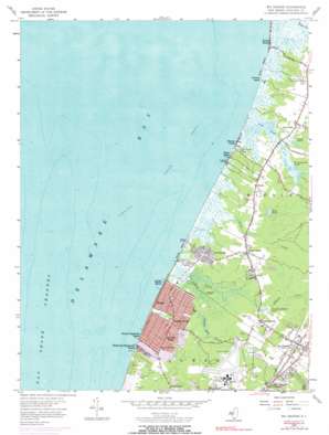
Rio Grande Topo Map New Jersey
To zoom in, hover over the map of Rio Grande
USGS Topo Quad 39074a8 - 1:24,000 scale
| Topo Map Name: | Rio Grande |
| USGS Topo Quad ID: | 39074a8 |
| Print Size: | ca. 21 1/4" wide x 27" high |
| Southeast Coordinates: | 39° N latitude / 74.875° W longitude |
| Map Center Coordinates: | 39.0625° N latitude / 74.9375° W longitude |
| U.S. State: | NJ |
| Filename: | o39074a8.jpg |
| Download Map JPG Image: | Rio Grande topo map 1:24,000 scale |
| Map Type: | Topographic |
| Topo Series: | 7.5´ |
| Map Scale: | 1:24,000 |
| Source of Map Images: | United States Geological Survey (USGS) |
| Alternate Map Versions: |
Rio Grande NJ 1944 Download PDF Buy paper map Rio Grande NJ 1956, updated 1957 Download PDF Buy paper map Rio Grande NJ 1956, updated 1967 Download PDF Buy paper map Rio Grande NJ 1956, updated 1972 Download PDF Buy paper map Rio Grande NJ 1956, updated 1990 Download PDF Buy paper map Rio Grande NJ 1994, updated 2000 Download PDF Buy paper map Rio Grande NJ 2011 Download PDF Buy paper map Rio Grande NJ 2014 Download PDF Buy paper map Rio Grande NJ 2016 Download PDF Buy paper map |
1:24,000 Topo Quads surrounding Rio Grande
Cedarville |
Dividing Creek |
Port Elizabeth |
Tuckahoe |
Marmora |
Fortescue |
Port Norris |
Heislerville |
Woodbine |
Sea Isle City |
Rio Grande |
Stone Harbor |
Avalon |
||
Cape May |
Wildwood |
|||
Lewes |
Cape Henlopen |
> Back to 39074a1 at 1:100,000 scale
> Back to 39074a1 at 1:250,000 scale
> Back to U.S. Topo Maps home
Rio Grande topo map: Gazetteer
Rio Grande: Airports
Cape May County Airport elevation 4m 13′Paramount Air Airport elevation 2m 6′
Wuerkers New Acres Farm Heliport elevation 6m 19′
Rio Grande: Bars
Fishing Creek Shoal elevation -4m -14′Rio Grande: Beaches
Cooks Beach elevation 2m 6′Kimbles Beach elevation 1m 3′
Miami Beach elevation 3m 9′
Sunray Beach elevation 2m 6′
Rio Grande: Islands
Hickory Island elevation 2m 6′Rio Grande: Lakes
Kay Pond elevation 1m 3′Pennsylvania Ponds elevation 2m 6′
Pierces Point Pond elevation 3m 9′
Rio Grande: Populated Places
Bowman Manor elevation 4m 13′Del Haven elevation 2m 6′
Dias Creek elevation 3m 9′
Erma Park elevation 6m 19′
Fishing Creek elevation 3m 9′
Green Creek elevation 4m 13′
Highs Beach elevation 2m 6′
Kimbles Beach elevation 2m 6′
Kimseytown elevation 3m 9′
King Crab Landing elevation 3m 9′
Miami Beach elevation 2m 6′
Norburys Landing elevation 3m 9′
North Highlands Beach elevation 3m 9′
Nummytown elevation 3m 9′
Pierces elevation 4m 13′
Pierces Point elevation 2m 6′
Reeds Beach elevation 2m 6′
Rio Grande elevation 6m 19′
Sally Marshall Crossing elevation 5m 16′
Villas elevation 3m 9′
Wildwood Highlands Beach elevation 3m 9′
Rio Grande: Reservoirs
Pumping Station Pond elevation 2m 6′Rio Grande: Streams
Dias Creek elevation 2m 6′Fishing Creek elevation 2m 6′
Fulling Mill Stream elevation 2m 6′
Green Creek elevation 0m 0′
Rio Grande: Summits
Potato Island elevation 2m 6′Rio Grande digital topo map on disk
Buy this Rio Grande topo map showing relief, roads, GPS coordinates and other geographical features, as a high-resolution digital map file on DVD:
Atlantic Coast (NY, NJ, PA, DE, MD, VA, NC)
Buy digital topo maps: Atlantic Coast (NY, NJ, PA, DE, MD, VA, NC)


