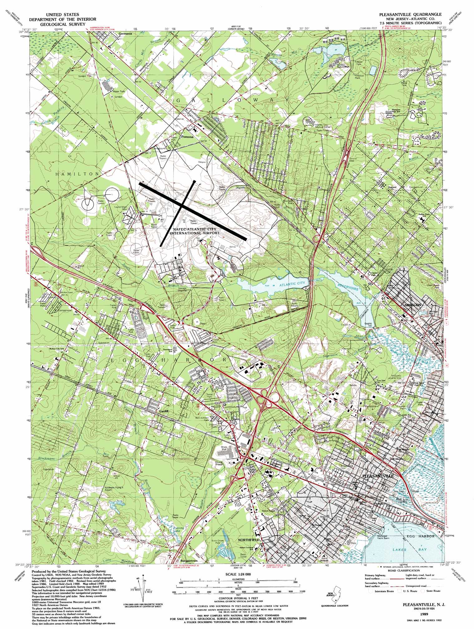
Pleasantville Topo Map New Jersey
To zoom in, hover over the map of Pleasantville
USGS Topo Quad 39074d5 - 1:24,000 scale
| Topo Map Name: | Pleasantville |
| USGS Topo Quad ID: | 39074d5 |
| Print Size: | ca. 21 1/4" wide x 27" high |
| Southeast Coordinates: | 39.375° N latitude / 74.5° W longitude |
| Map Center Coordinates: | 39.4375° N latitude / 74.5625° W longitude |
| U.S. State: | NJ |
| Filename: | o39074d5.jpg |
| Download Map JPG Image: | Pleasantville topo map 1:24,000 scale |
| Map Type: | Topographic |
| Topo Series: | 7.5´ |
| Map Scale: | 1:24,000 |
| Source of Map Images: | United States Geological Survey (USGS) |
| Alternate Map Versions: |
Pleasantville NJ 1952, updated 1955 Download PDF Buy paper map Pleasantville NJ 1952, updated 1967 Download PDF Buy paper map Pleasantville NJ 1952, updated 1974 Download PDF Buy paper map Pleasantville NJ 1989, updated 1989 Download PDF Buy paper map Pleasantville NJ 1994, updated 1998 Download PDF Buy paper map Pleasantville NJ 2011 Download PDF Buy paper map Pleasantville NJ 2014 Download PDF Buy paper map Pleasantville NJ 2016 Download PDF Buy paper map |
1:24,000 Topo Quads surrounding Pleasantville
Hammonton |
Atsion |
Jenkins |
Oswego Lake |
West Creek |
Newtonville |
Egg Harbor City |
Green Bank |
New Gretna |
Tuckerton |
Dorothy |
Mays Landing |
Pleasantville |
Oceanville |
Brigantine Inlet |
Tuckahoe |
Marmora |
Ocean City |
Atlantic City |
|
Woodbine |
Sea Isle City |
> Back to 39074a1 at 1:100,000 scale
> Back to 39074a1 at 1:250,000 scale
> Back to U.S. Topo Maps home
Pleasantville topo map: Gazetteer
Pleasantville: Airports
Atlantic City International Airport elevation 19m 62′Atlantic City Medical Center - Mainland Division Heliport elevation 19m 62′
Atlantic County Helistop elevation 6m 19′
Germania Heliport elevation 21m 68′
McGinnis Airport elevation 3m 9′
McGinnis Landing Strip elevation 3m 9′
Nordheim Flying K Airpark elevation 12m 39′
Pleasantville: Dams
Absalom Doughty Pond Dam elevation 2m 6′Doughty Pond Upper Dam elevation 7m 22′
Pleasantville: Harbors
Municipal Yacht Basin elevation 4m 13′Pleasantville: Parks
Birch Grove Park elevation 5m 16′Green Acres Park elevation 16m 52′
Heritage Park elevation 4m 13′
Heritage Park elevation 4m 13′
Seasor Park elevation 4m 13′
Pleasantville: Populated Places
Cardiff elevation 13m 42′Mount Pleasant elevation 7m 22′
Pinehurst elevation 20m 65′
Pleasantville elevation 6m 19′
Pomona elevation 20m 65′
Pleasantville: Reservoirs
Atlantic City Reservoir elevation 2m 6′Patcong Lake elevation 4m 13′
Pleasantville: Streams
Ables Run elevation 1m 3′Ables Run elevation 1m 3′
Blackmans Branch elevation 9m 29′
Cedar Branch elevation 6m 19′
Conovers Creek elevation 1m 3′
Conovers Creek elevation 1m 3′
Ingersolls Branch elevation 1m 3′
Little Meadow Run elevation 3m 9′
North Branch Absecon Creek elevation 3m 9′
South Branch Absecon Creek elevation 8m 26′
Pleasantville digital topo map on disk
Buy this Pleasantville topo map showing relief, roads, GPS coordinates and other geographical features, as a high-resolution digital map file on DVD:
Atlantic Coast (NY, NJ, PA, DE, MD, VA, NC)
Buy digital topo maps: Atlantic Coast (NY, NJ, PA, DE, MD, VA, NC)
 map DVD")