New Gretna Topo Map New Jersey
To zoom in, hover over the map of New Gretna
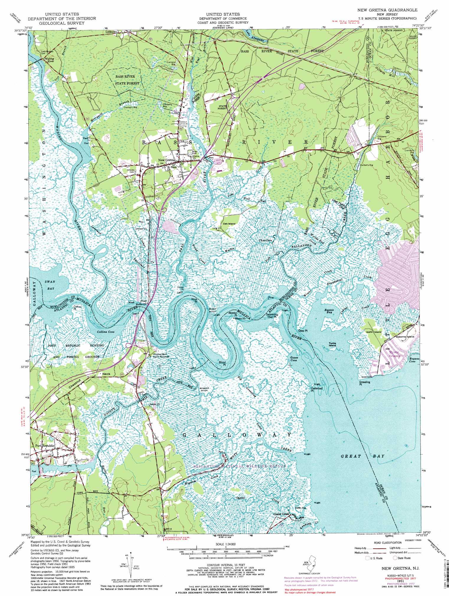
USGS Topo Quad 39074e4 - 1:24,000 scale
| Topo Map Name: | New Gretna |
| USGS Topo Quad ID: | 39074e4 |
| Print Size: | ca. 21 1/4" wide x 27" high |
| Southeast Coordinates: | 39.5° N latitude / 74.375° W longitude |
| Map Center Coordinates: | 39.5625° N latitude / 74.4375° W longitude |
| U.S. State: | NJ |
| Filename: | o39074e4.jpg |
| Download Map JPG Image: | New Gretna topo map 1:24,000 scale |
| Map Type: | Topographic |
| Topo Series: | 7.5´ |
| Map Scale: | 1:24,000 |
| Source of Map Images: | United States Geological Survey (USGS) |
| Alternate Map Versions: |
New Gretna NJ 1951, updated 1954 Download PDF Buy paper map New Gretna NJ 1951, updated 1962 Download PDF Buy paper map New Gretna NJ 1951, updated 1967 Download PDF Buy paper map New Gretna NJ 1951, updated 1973 Download PDF Buy paper map New Gretna NJ 1951, updated 1981 Download PDF Buy paper map New Gretna NJ 1951, updated 1981 Download PDF Buy paper map New Gretna NJ 2011 Download PDF Buy paper map New Gretna NJ 2014 Download PDF Buy paper map New Gretna NJ 2016 Download PDF Buy paper map |
1:24,000 Topo Quads surrounding New Gretna
Indian Mills |
Chatsworth |
Woodmansie |
Brookville |
Forked River |
Atsion |
Jenkins |
Oswego Lake |
West Creek |
Ship Bottom |
Egg Harbor City |
Green Bank |
New Gretna |
Tuckerton |
Beach Haven |
Mays Landing |
Pleasantville |
Oceanville |
Brigantine Inlet |
|
Marmora |
Ocean City |
Atlantic City |
> Back to 39074e1 at 1:100,000 scale
> Back to 39074a1 at 1:250,000 scale
> Back to U.S. Topo Maps home
New Gretna topo map: Gazetteer
New Gretna: Bays
Basses Bay elevation 0m 0′Bogans Cove elevation 0m 0′
Collins Cove elevation 0m 0′
Goose Cove elevation 0m 0′
Great Bay elevation 0m 0′
Swan Bay elevation 0m 0′
New Gretna: Canals
Blood Ditch elevation 0m 0′Pollys Ditch elevation 1m 3′
Quaker Ditch elevation 0m 0′
New Gretna: Capes
Akimbo Point elevation 1m 3′Bass River Neck elevation 1m 3′
Blood Point elevation 1m 3′
Chestnut Neck elevation 3m 9′
Collins Point elevation 1m 3′
Deep Point elevation 1m 3′
Doctors Point elevation 0m 0′
Graveling Point elevation 0m 0′
Moss Point elevation 0m 0′
Oysterbed Point elevation 0m 0′
Swimming Over Point elevation 1m 3′
New Gretna: Channels
Loveland Thorofare elevation 0m 0′Mathis Thorofare elevation 1m 3′
New Gretna: Crossings
Interchange 48 elevation 2m 6′Interchange 50 elevation 2m 6′
Interchange 52 elevation 4m 13′
New Gretna: Guts
Big Graveling Creek elevation 1m 3′New Gretna: Islands
Oak Island elevation 1m 3′Osborne Island elevation 3m 9′
Turtle Island elevation 1m 3′
Wells Island elevation 1m 3′
New Gretna: Lakes
Mill Pond elevation 0m 0′New Gretna: Parks
Brigantine National Wildlife Refuge elevation 1m 3′Chestnut Neck Battle Monument elevation 2m 6′
Port Republic Wildlife Management Area elevation 2m 6′
New Gretna: Populated Places
Bass River elevation 1m 3′Higbeeville elevation 3m 9′
Johnsontown elevation 3m 9′
Leektown elevation 10m 32′
Merrygold elevation 1m 3′
Mystic Islands elevation 1m 3′
New Gretna elevation 2m 6′
Oyster Creek elevation 1m 3′
Port Republic elevation 4m 13′
New Gretna: Streams
Ballinger Creek elevation 0m 0′Bass River elevation 0m 0′
Big Creek elevation 0m 0′
Broad Creek elevation 0m 0′
Bubs Creek elevation 0m 0′
Cramer Creek elevation 0m 0′
East Branch Bass River elevation 0m 0′
Fish Creek elevation 1m 3′
Ives Branch elevation 0m 0′
Jobs Creek elevation 0m 0′
Judies Creek elevation 0m 0′
Landing Creek elevation 0m 0′
Lower Pasture Creek elevation 1m 3′
Mattix Run elevation 0m 0′
Merrygold Branch elevation 0m 0′
Mott Creek elevation 0m 0′
Mullica River elevation 0m 0′
Nacote Creek elevation 0m 0′
Oyster Creek elevation 0m 0′
Roundabout Creek elevation 0m 0′
Wading River elevation 0m 0′
West Branch Bass River elevation 0m 0′
Wigwam Creek elevation 0m 0′
Winter Creek elevation 1m 3′
Wolf Run elevation 0m 0′
Worlds End Creek elevation 0m 0′
New Gretna digital topo map on disk
Buy this New Gretna topo map showing relief, roads, GPS coordinates and other geographical features, as a high-resolution digital map file on DVD:
Atlantic Coast (NY, NJ, PA, DE, MD, VA, NC)
Buy digital topo maps: Atlantic Coast (NY, NJ, PA, DE, MD, VA, NC)
 map DVD")