West Creek Topo Map New Jersey
To zoom in, hover over the map of West Creek
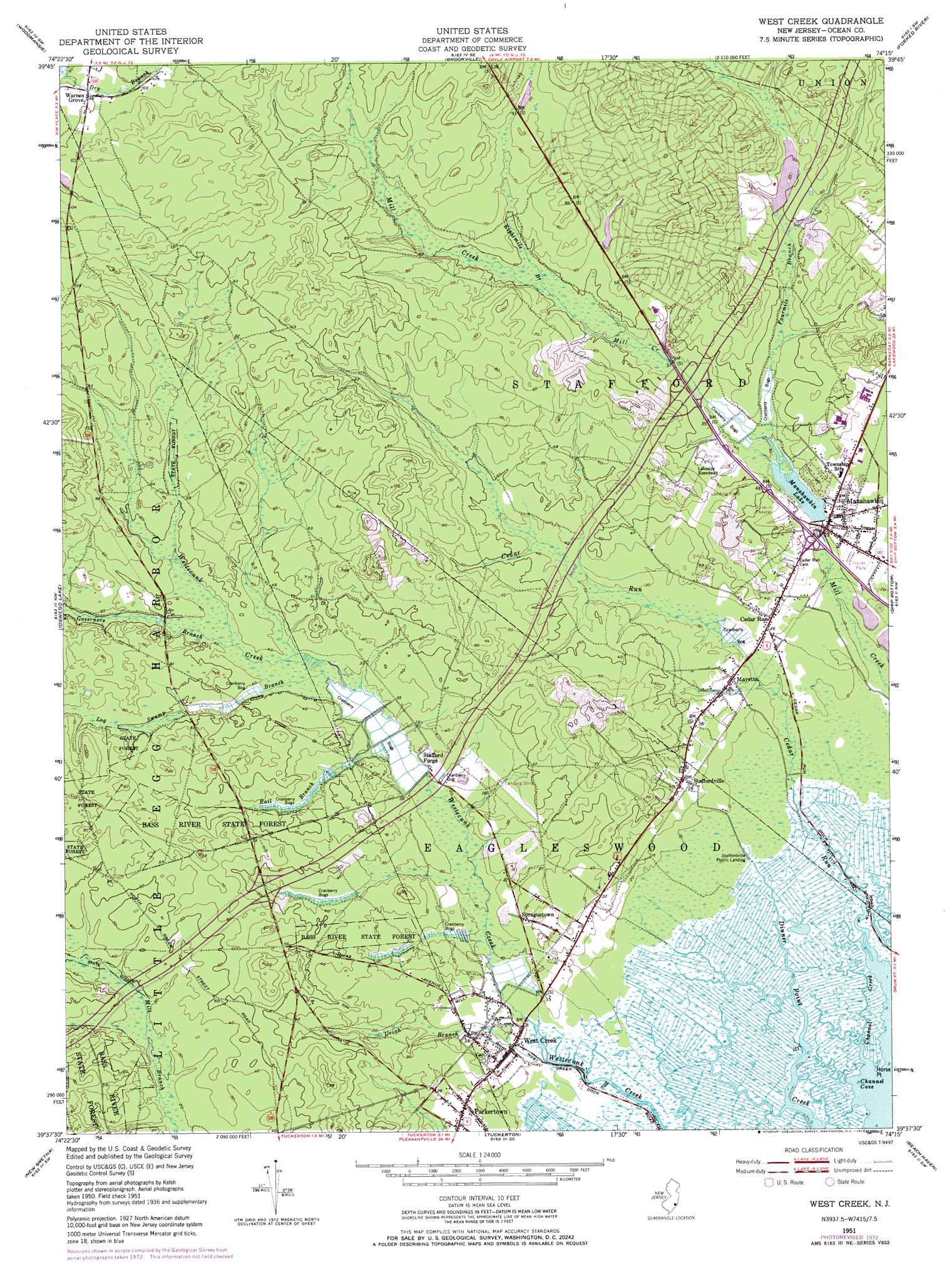
USGS Topo Quad 39074f3 - 1:24,000 scale
| Topo Map Name: | West Creek |
| USGS Topo Quad ID: | 39074f3 |
| Print Size: | ca. 21 1/4" wide x 27" high |
| Southeast Coordinates: | 39.625° N latitude / 74.25° W longitude |
| Map Center Coordinates: | 39.6875° N latitude / 74.3125° W longitude |
| U.S. State: | NJ |
| Filename: | o39074f3.jpg |
| Download Map JPG Image: | West Creek topo map 1:24,000 scale |
| Map Type: | Topographic |
| Topo Series: | 7.5´ |
| Map Scale: | 1:24,000 |
| Source of Map Images: | United States Geological Survey (USGS) |
| Alternate Map Versions: |
West Creek NJ 1951, updated 1954 Download PDF Buy paper map West Creek NJ 1951, updated 1972 Download PDF Buy paper map West Creek NJ 1951, updated 1973 Download PDF Buy paper map West Creek NJ 2011 Download PDF Buy paper map West Creek NJ 2014 Download PDF Buy paper map West Creek NJ 2016 Download PDF Buy paper map |
1:24,000 Topo Quads surrounding West Creek
Browns Mills |
Whiting |
Keswick Grove |
Toms River |
Seaside Park |
Chatsworth |
Woodmansie |
Brookville |
Forked River |
Barnegat Light |
Jenkins |
Oswego Lake |
West Creek |
Ship Bottom |
Long Beach Ne |
Green Bank |
New Gretna |
Tuckerton |
Beach Haven |
|
Pleasantville |
Oceanville |
Brigantine Inlet |
> Back to 39074e1 at 1:100,000 scale
> Back to 39074a1 at 1:250,000 scale
> Back to U.S. Topo Maps home
West Creek topo map: Gazetteer
West Creek: Airports
Beachview elevation 27m 88′Eagles Nest Airport elevation 10m 32′
Manahawkin elevation 18m 59′
Southern Ocean County Hospital Heliport elevation 16m 52′
West Creek: Bays
Channel Cove elevation 0m 0′West Creek: Capes
Horse Point elevation 2m 6′West Creek: Crossings
Interchange 58 elevation 12m 39′Interchange 63 elevation 12m 39′
West Creek: Dams
Holiday Lake Dam elevation 13m 42′Manahawkin Lake Dam elevation 7m 22′
Stafford Forge Dam elevation 6m 19′
West Creek: Parks
Stafford Forge Wildlife Management Area elevation 9m 29′West Creek: Populated Places
Cedar Run elevation 8m 26′Coxstown elevation 7m 22′
Deer Lake Park elevation 12m 39′
Deerhaven elevation 12m 39′
Eagleswood Village elevation 13m 42′
Lakeview Terrace elevation 13m 42′
Manahawkin elevation 6m 19′
Mayetta elevation 8m 26′
Ocean Acres elevation 39m 127′
Parkertown elevation 4m 13′
Spraguetown elevation 7m 22′
Stafford Forge elevation 6m 19′
Staffordville elevation 9m 29′
Warren Grove elevation 30m 98′
West Creek elevation 3m 9′
West Creek: Reservoirs
Holiday Lake elevation 13m 42′Manahawkin Lake elevation 7m 22′
West Creek: Streams
Cedar Run elevation 0m 0′Channel Creek elevation 0m 0′
Eightmile Branch elevation 13m 42′
Fourmile Branch elevation 9m 29′
Governors Branch elevation 10m 32′
Log Swamp Branch elevation 9m 29′
Rail Branch elevation 9m 29′
Rail Swamp Branch elevation 3m 9′
Uriah Branch elevation 1m 3′
West Creek digital topo map on disk
Buy this West Creek topo map showing relief, roads, GPS coordinates and other geographical features, as a high-resolution digital map file on DVD:
Atlantic Coast (NY, NJ, PA, DE, MD, VA, NC)
Buy digital topo maps: Atlantic Coast (NY, NJ, PA, DE, MD, VA, NC)
 map DVD")