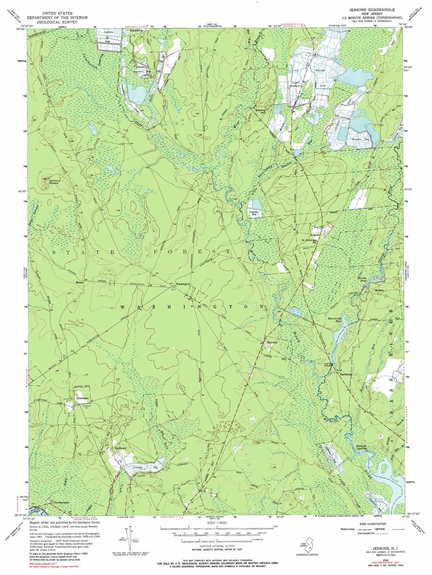
Jenkins Topo Map New Jersey
To zoom in, hover over the map of Jenkins
USGS Topo Quad 39074f5 - 1:24,000 scale
| Topo Map Name: | Jenkins |
| USGS Topo Quad ID: | 39074f5 |
| Print Size: | ca. 21 1/4" wide x 27" high |
| Southeast Coordinates: | 39.625° N latitude / 74.5° W longitude |
| Map Center Coordinates: | 39.6875° N latitude / 74.5625° W longitude |
| U.S. State: | NJ |
| Filename: | o39074f5.jpg |
| Download Map JPG Image: | Jenkins topo map 1:24,000 scale |
| Map Type: | Topographic |
| Topo Series: | 7.5´ |
| Map Scale: | 1:24,000 |
| Source of Map Images: | United States Geological Survey (USGS) |
| Alternate Map Versions: |
Jenkins NJ 1956, updated 1957 Download PDF Buy paper map Jenkins NJ 1956, updated 1964 Download PDF Buy paper map Jenkins NJ 1956, updated 1988 Download PDF Buy paper map Jenkins NJ 1997, updated 1998 Download PDF Buy paper map Jenkins NJ 2011 Download PDF Buy paper map Jenkins NJ 2014 Download PDF Buy paper map Jenkins NJ 2016 Download PDF Buy paper map |
1:24,000 Topo Quads surrounding Jenkins
Mount Holly |
Pemberton |
Browns Mills |
Whiting |
Keswick Grove |
Medford Lakes |
Indian Mills |
Chatsworth |
Woodmansie |
Brookville |
Hammonton |
Atsion |
Jenkins |
Oswego Lake |
West Creek |
Newtonville |
Egg Harbor City |
Green Bank |
New Gretna |
Tuckerton |
Dorothy |
Mays Landing |
Pleasantville |
Oceanville |
Brigantine Inlet |
> Back to 39074e1 at 1:100,000 scale
> Back to 39074a1 at 1:250,000 scale
> Back to U.S. Topo Maps home
Jenkins topo map: Gazetteer
Jenkins: Capes
Jenkins Neck elevation 12m 39′Jenkins: Dams
Harrisville Dam elevation 3m 9′Jenkins: Lakes
Martha Pond elevation 4m 13′Jenkins: Populated Places
Bulltown elevation 11m 36′Charcoal Landing elevation 2m 6′
Crowleytown elevation 3m 9′
Harrisville elevation 4m 13′
Jenkins elevation 13m 42′
Martha elevation 10m 32′
Maxwell elevation 12m 39′
Mount elevation 18m 59′
Tylertown elevation 18m 59′
Washington elevation 18m 59′
Jenkins: Reservoirs
Harrisville Pond elevation 1m 3′Jenkins: Streams
Arnold Branch elevation 0m 0′Beaver Branch elevation 2m 6′
Beaver Run elevation 0m 0′
Buck Run elevation 10m 32′
Bulls Branch elevation 12m 39′
Featherbed Branch elevation 14m 45′
Hospitality Brook elevation 9m 29′
Little Hauken Run elevation 9m 29′
Mile Run elevation 15m 49′
Oswego River elevation 0m 0′
Tub Mill Branch elevation 0m 0′
Tulpehocken Creek elevation 10m 32′
West Branch Wading River elevation 0m 0′
Jenkins: Summits
Jemima Mount elevation 31m 101′Stormy Hill elevation 22m 72′
Jenkins: Swamps
Friendship Cranberry Bogs elevation 15m 49′Hog Wallow Cranberry Bogs elevation 16m 52′
Jenkins digital topo map on disk
Buy this Jenkins topo map showing relief, roads, GPS coordinates and other geographical features, as a high-resolution digital map file on DVD:
Atlantic Coast (NY, NJ, PA, DE, MD, VA, NC)
Buy digital topo maps: Atlantic Coast (NY, NJ, PA, DE, MD, VA, NC)
 map DVD")