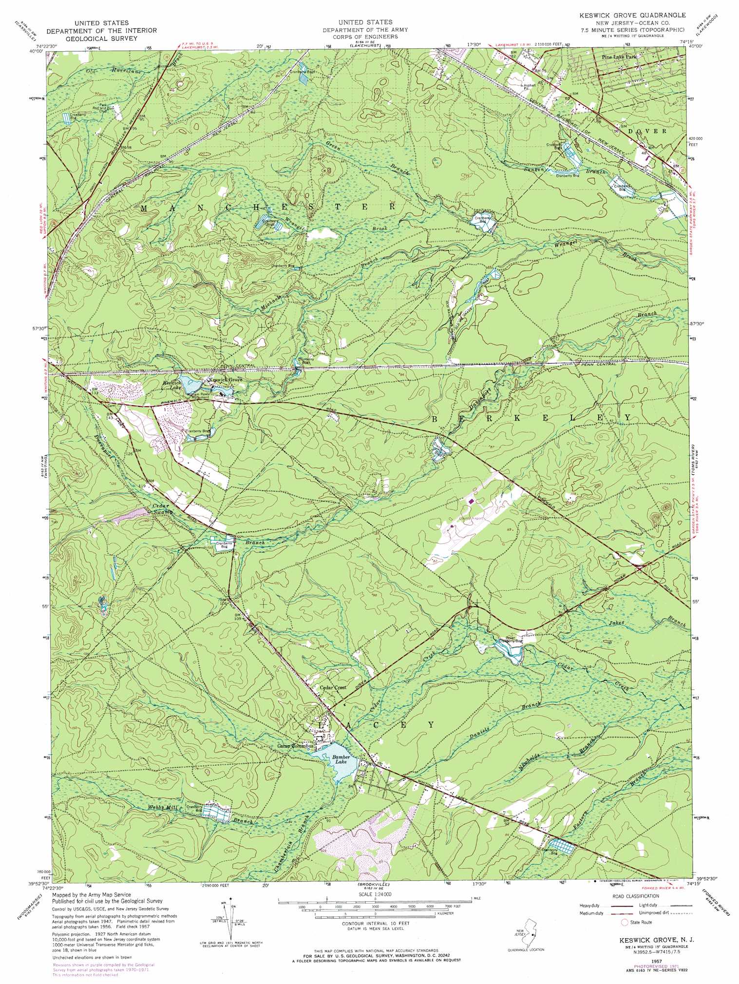
Keswick Grove Topo Map New Jersey
To zoom in, hover over the map of Keswick Grove
USGS Topo Quad 39074h3 - 1:24,000 scale
| Topo Map Name: | Keswick Grove |
| USGS Topo Quad ID: | 39074h3 |
| Print Size: | ca. 21 1/4" wide x 27" high |
| Southeast Coordinates: | 39.875° N latitude / 74.25° W longitude |
| Map Center Coordinates: | 39.9375° N latitude / 74.3125° W longitude |
| U.S. State: | NJ |
| Filename: | o39074h3.jpg |
| Download Map JPG Image: | Keswick Grove topo map 1:24,000 scale |
| Map Type: | Topographic |
| Topo Series: | 7.5´ |
| Map Scale: | 1:24,000 |
| Source of Map Images: | United States Geological Survey (USGS) |
| Alternate Map Versions: |
Keswick Grove NJ 1951 Download PDF Buy paper map Keswick Grove NJ 1957, updated 1961 Download PDF Buy paper map Keswick Grove NJ 1957, updated 1969 Download PDF Buy paper map Keswick Grove NJ 1957, updated 1971 Download PDF Buy paper map Keswick Grove NJ 2011 Download PDF Buy paper map Keswick Grove NJ 2014 Download PDF Buy paper map Keswick Grove NJ 2016 Download PDF Buy paper map |
1:24,000 Topo Quads surrounding Keswick Grove
Allentown |
Roosevelt |
Adelphia |
Farmingdale |
Asbury Park |
New Egypt |
Cassville |
Lakehurst |
Lakewood |
Point Pleasant |
Browns Mills |
Whiting |
Keswick Grove |
Toms River |
Seaside Park |
Chatsworth |
Woodmansie |
Brookville |
Forked River |
Barnegat Light |
Jenkins |
Oswego Lake |
West Creek |
Ship Bottom |
Long Beach Ne |
> Back to 39074e1 at 1:100,000 scale
> Back to 39074a1 at 1:250,000 scale
> Back to U.S. Topo Maps home
Keswick Grove topo map: Gazetteer
Keswick Grove: Airports
Robert J Miller Air Park elevation 24m 78′Keswick Grove: Dams
Bamber Lake Dam elevation 23m 75′Upper Kesick Dam elevation 29m 95′
Wrangel Brook Dam elevation 12m 39′
Wrights Dam elevation 36m 118′
Keswick Grove: Lakes
Keswick Lake elevation 28m 91′Keswick Grove: Parks
Whiting Wildlife Management Area elevation 36m 118′William Raws Monument elevation 27m 88′
Keswick Grove: Populated Places
Bamber Lake elevation 24m 78′Camp Columbus elevation 27m 88′
Cedar Crest elevation 29m 95′
Crestwood Village elevation 40m 131′
Crossley (historical) elevation 16m 52′
Davenport (historical) elevation 31m 101′
Dover Forge elevation 17m 55′
Holiday Heights elevation 13m 42′
Keswick Grove elevation 32m 104′
Pine Ridge at Crestwood elevation 23m 75′
Wrangell Brook Park elevation 14m 45′
Keswick Grove: Reservoirs
Bamber Lake elevation 23m 75′Harry Wrights Lake elevation 36m 118′
Keswick Grove: Streams
Chamberlain Branch elevation 21m 68′Daniels Branch elevation 13m 42′
Green Branch elevation 14m 45′
Little Hurricane Branch elevation 29m 95′
Michaels Run elevation 12m 39′
Newbolds Branch elevation 12m 39′
Webbs Mill Branch elevation 24m 78′
Keswick Grove: Swamps
Cedar Swamp elevation 31m 101′Dover Cranberry Bog elevation 15m 49′
Keswick Grove digital topo map on disk
Buy this Keswick Grove topo map showing relief, roads, GPS coordinates and other geographical features, as a high-resolution digital map file on DVD:
Atlantic Coast (NY, NJ, PA, DE, MD, VA, NC)
Buy digital topo maps: Atlantic Coast (NY, NJ, PA, DE, MD, VA, NC)
 map DVD")