Port Norris Topo Map New Jersey
To zoom in, hover over the map of Port Norris
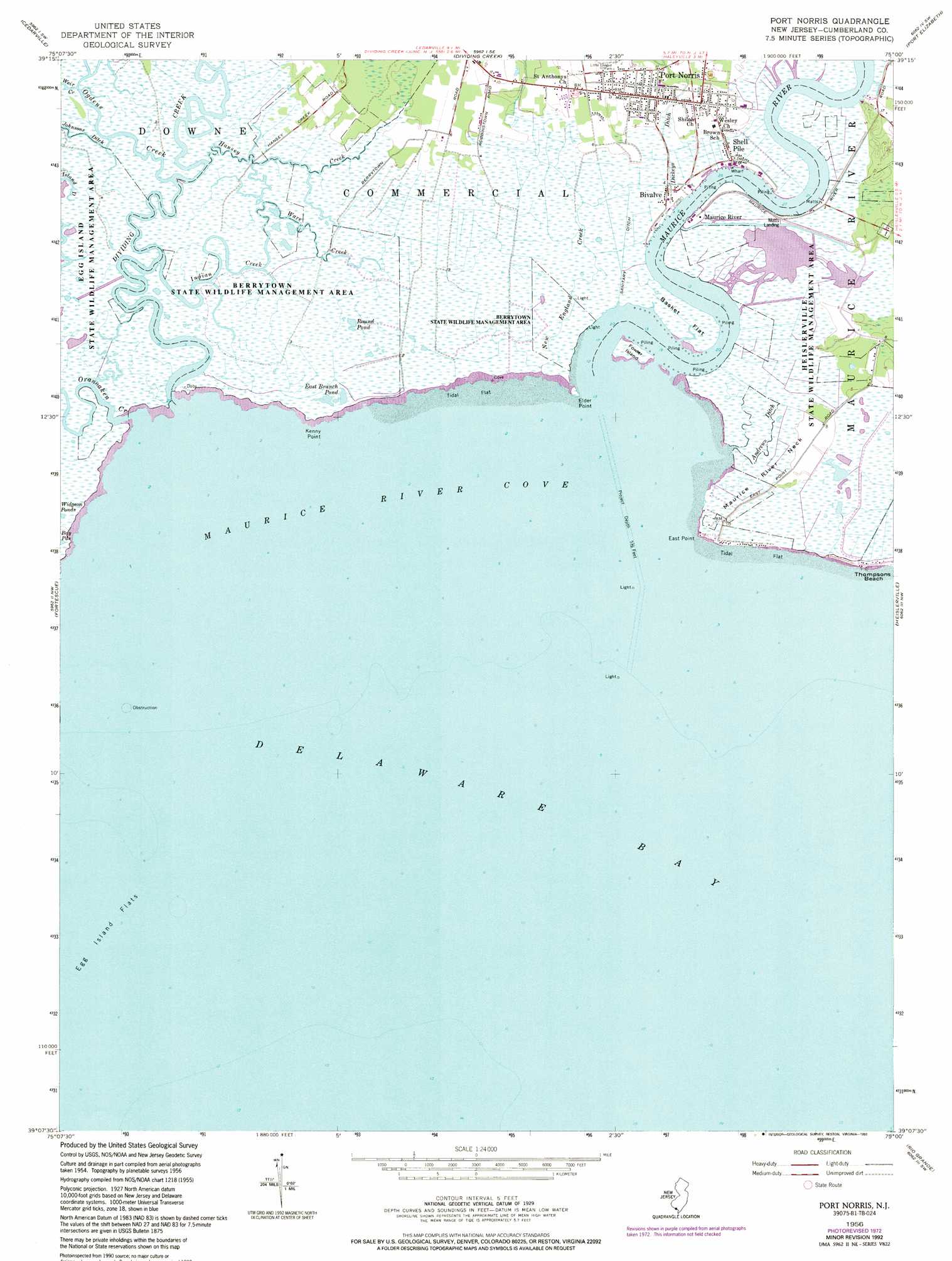
USGS Topo Quad 39075b1 - 1:24,000 scale
| Topo Map Name: | Port Norris |
| USGS Topo Quad ID: | 39075b1 |
| Print Size: | ca. 21 1/4" wide x 27" high |
| Southeast Coordinates: | 39.125° N latitude / 75° W longitude |
| Map Center Coordinates: | 39.1875° N latitude / 75.0625° W longitude |
| U.S. State: | NJ |
| Filename: | o39075b1.jpg |
| Download Map JPG Image: | Port Norris topo map 1:24,000 scale |
| Map Type: | Topographic |
| Topo Series: | 7.5´ |
| Map Scale: | 1:24,000 |
| Source of Map Images: | United States Geological Survey (USGS) |
| Alternate Map Versions: |
Port Norris NJ 1956, updated 1958 Download PDF Buy paper map Port Norris NJ 1956, updated 1968 Download PDF Buy paper map Port Norris NJ 1956, updated 1973 Download PDF Buy paper map Port Norris NJ 1956, updated 1991 Download PDF Buy paper map Port Norris NJ 1956, updated 1993 Download PDF Buy paper map Port Norris NJ 2011 Download PDF Buy paper map Port Norris NJ 2014 Download PDF Buy paper map Port Norris NJ 2017 Download PDF Buy paper map |
1:24,000 Topo Quads surrounding Port Norris
Shiloh |
Bridgeton |
Millville |
Five Points |
Dorothy |
Ben Davis Point |
Cedarville |
Dividing Creek |
Port Elizabeth |
Tuckahoe |
Fortescue |
Port Norris |
Heislerville |
Woodbine |
|
Bennetts Pier |
Rio Grande |
Stone Harbor |
||
Mispillion River |
Cape May |
Wildwood |
> Back to 39075a1 at 1:100,000 scale
> Back to 39074a1 at 1:250,000 scale
> Back to U.S. Topo Maps home
Port Norris topo map: Gazetteer
Port Norris: Bays
Maurice River Cove elevation -3m -10′Port Norris: Canals
Andrews Ditch elevation 1m 3′Port Norris: Capes
East Point elevation 0m 0′Elder Point elevation 0m 0′
Kenny Point elevation 0m 0′
Maurice River Neck elevation 1m 3′
Port Norris: Flats
Basket Flat elevation 1m 3′Port Norris: Guts
Indian Creek elevation 1m 3′Island Ditch elevation 0m 0′
Wave Creek elevation 1m 3′
Port Norris: Islands
Fowler Island elevation 1m 3′Port Norris: Lakes
Bay Ponds elevation 1m 3′East Branch Pond elevation 0m 0′
Round Pond elevation 0m 0′
Port Norris: Parks
Heislerville Fish and Wildlife Management Area elevation 1m 3′Port Norris: Populated Places
Bivalve elevation 1m 3′Maurice River elevation 1m 3′
Port Norris elevation 3m 9′
Shell Pile elevation 1m 3′
Port Norris: Streams
Dickeys Ditch elevation 1m 3′Dividing Creek elevation -2m -7′
Hansey Creek elevation 0m 0′
Maurice River elevation 0m 0′
New England Creek elevation 1m 3′
Ogdens Creek elevation 1m 3′
Oranoaken Creek elevation -2m -7′
Ware Creek elevation 1m 3′
Port Norris digital topo map on disk
Buy this Port Norris topo map showing relief, roads, GPS coordinates and other geographical features, as a high-resolution digital map file on DVD:
Atlantic Coast (NY, NJ, PA, DE, MD, VA, NC)
Buy digital topo maps: Atlantic Coast (NY, NJ, PA, DE, MD, VA, NC)
 map DVD")