Fortescue Topo Map New Jersey
To zoom in, hover over the map of Fortescue
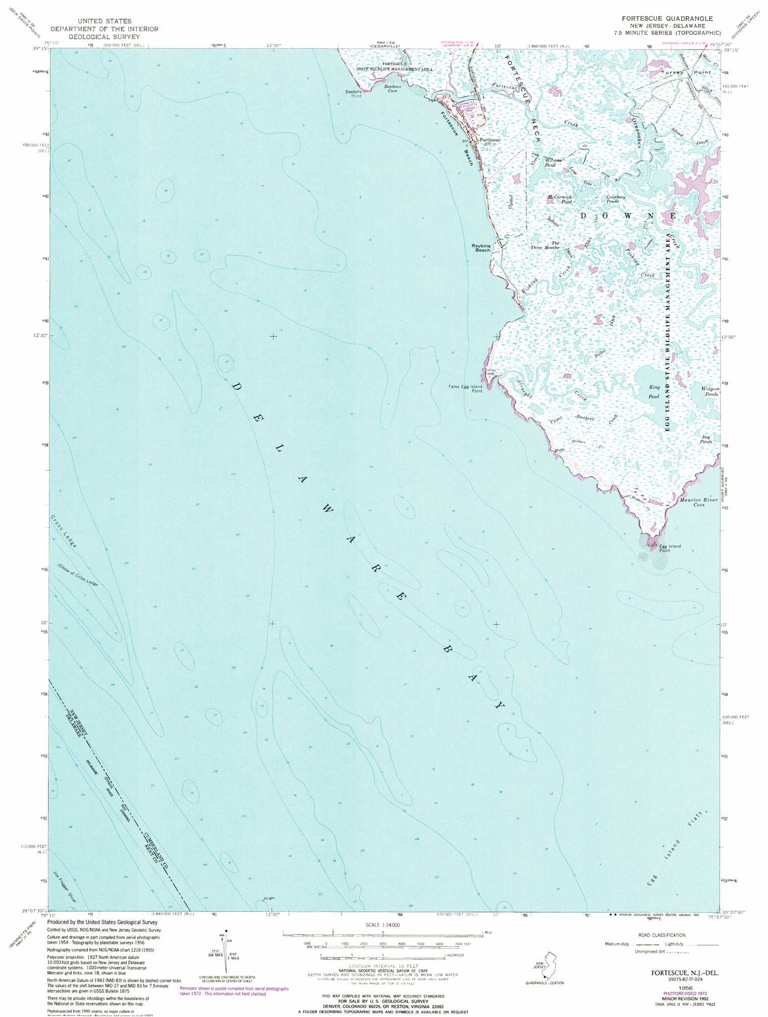
USGS Topo Quad 39075b2 - 1:24,000 scale
| Topo Map Name: | Fortescue |
| USGS Topo Quad ID: | 39075b2 |
| Print Size: | ca. 21 1/4" wide x 27" high |
| Southeast Coordinates: | 39.125° N latitude / 75.125° W longitude |
| Map Center Coordinates: | 39.1875° N latitude / 75.1875° W longitude |
| U.S. States: | NJ, DE |
| Filename: | o39075b2.jpg |
| Download Map JPG Image: | Fortescue topo map 1:24,000 scale |
| Map Type: | Topographic |
| Topo Series: | 7.5´ |
| Map Scale: | 1:24,000 |
| Source of Map Images: | United States Geological Survey (USGS) |
| Alternate Map Versions: |
Fortescue NJ 1956, updated 1957 Download PDF Buy paper map Fortescue NJ 1956, updated 1972 Download PDF Buy paper map Fortescue NJ 1956, updated 1992 Download PDF Buy paper map Fortescue NJ 1956, updated 1993 Download PDF Buy paper map Fortescue NJ 2011 Download PDF Buy paper map Fortescue NJ 2014 Download PDF Buy paper map Fortescue NJ 2017 Download PDF Buy paper map |
1:24,000 Topo Quads surrounding Fortescue
Canton |
Shiloh |
Bridgeton |
Millville |
Five Points |
Bombay Hook |
Ben Davis Point |
Cedarville |
Dividing Creek |
Port Elizabeth |
Little Creek |
Fortescue |
Port Norris |
Heislerville |
|
Frederica |
Bennetts Pier |
Rio Grande |
||
Milford |
Mispillion River |
Cape May |
> Back to 39075a1 at 1:100,000 scale
> Back to 39074a1 at 1:250,000 scale
> Back to U.S. Topo Maps home
Fortescue topo map: Gazetteer
Fortescue: Bars
Cross Ledge elevation 0m 0′Elbow of Cross Ledge elevation -5m -17′
Joe Flogger Shoal elevation 0m 0′
Fortescue: Bays
Beadon Cove elevation 0m 0′Fortescue: Beaches
Fortescue Beach elevation 0m 0′Fortescue: Canals
Indian Ditch elevation 0m 0′Johnsons Ditch elevation 0m 0′
Fortescue: Capes
Beadon Point elevation 0m 0′Egg Island Point elevation -4m -14′
False Egg Island Point elevation -3m -10′
Fortescue: Channels
Brandywine Range elevation -11m -37′Main Maull Range elevation 0m 0′
Miah Maull Range elevation -11m -37′
Fortescue: Flats
Egg Island Flats elevation -4m -14′Fortescue: Guts
Boiler Creek elevation 0m 0′Elder Gut elevation 0m 0′
Fortescue Creek elevation 0m 0′
Fortescue: Islands
Egg Island (historical) elevation 0m 0′Fortescue: Lakes
Courtney Ponds elevation 0m 0′King Pond elevation 0m 0′
McCormick Pond elevation 0m 0′
The Three Mouths elevation 0m 0′
Widgeon Ponds elevation 0m 0′
Wilmas Pond elevation 0m 0′
Fortescue: Parks
Egg Island Fish and Wildlife Management Area elevation 0m 0′Fortescue: Populated Places
Fortescue elevation 0m 0′Fortescue: Streams
Beadon Creek elevation 0m 0′Fishing Creek elevation 0m 0′
Lower Brothers Creek elevation 0m 0′
Middle Brothers Creek elevation 0m 0′
Oyster Creek elevation 0m 0′
Piersons Ditch elevation 0m 0′
Straight Creek elevation -1m -4′
Upper Brothers Creek elevation 0m 0′
Fortescue digital topo map on disk
Buy this Fortescue topo map showing relief, roads, GPS coordinates and other geographical features, as a high-resolution digital map file on DVD:
Atlantic Coast (NY, NJ, PA, DE, MD, VA, NC)
Buy digital topo maps: Atlantic Coast (NY, NJ, PA, DE, MD, VA, NC)
 map DVD")