Ben Davis Point Topo Map New Jersey
To zoom in, hover over the map of Ben Davis Point
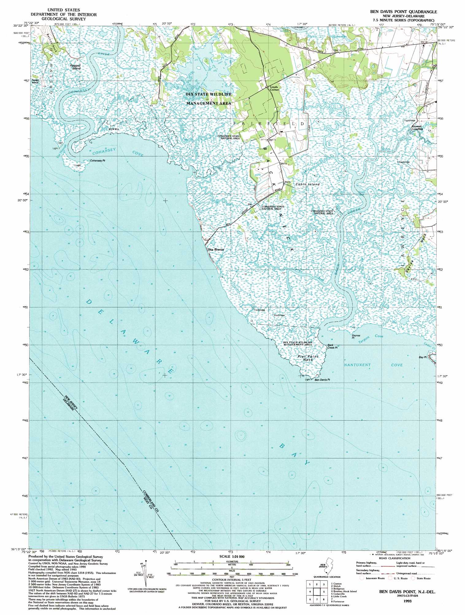
USGS Topo Quad 39075c3 - 1:24,000 scale
| Topo Map Name: | Ben Davis Point |
| USGS Topo Quad ID: | 39075c3 |
| Print Size: | ca. 21 1/4" wide x 27" high |
| Southeast Coordinates: | 39.25° N latitude / 75.25° W longitude |
| Map Center Coordinates: | 39.3125° N latitude / 75.3125° W longitude |
| U.S. States: | NJ, DE |
| Filename: | o39075c3.jpg |
| Download Map JPG Image: | Ben Davis Point topo map 1:24,000 scale |
| Map Type: | Topographic |
| Topo Series: | 7.5´ |
| Map Scale: | 1:24,000 |
| Source of Map Images: | United States Geological Survey (USGS) |
| Alternate Map Versions: |
Ben Davis Point NJ 1949 Download PDF Buy paper map Ben Davis Point NJ 1956, updated 1958 Download PDF Buy paper map Ben Davis Point NJ 1956, updated 1969 Download PDF Buy paper map Ben Davis Point NJ 1956, updated 1972 Download PDF Buy paper map Ben Davis Point NJ 1956, updated 1990 Download PDF Buy paper map Ben Davis Point NJ 1993, updated 1993 Download PDF Buy paper map Ben Davis Point NJ 2011 Download PDF Buy paper map Ben Davis Point NJ 2014 Download PDF Buy paper map Ben Davis Point NJ 2017 Download PDF Buy paper map |
1:24,000 Topo Quads surrounding Ben Davis Point
Delaware City |
Salem |
Alloway |
Elmer |
Newfield |
Taylors Bridge |
Canton |
Shiloh |
Bridgeton |
Millville |
Smyrna |
Bombay Hook |
Ben Davis Point |
Cedarville |
Dividing Creek |
Dover |
Little Creek |
Fortescue |
Port Norris |
|
Wyoming |
Frederica |
Bennetts Pier |
> Back to 39075a1 at 1:100,000 scale
> Back to 39074a1 at 1:250,000 scale
> Back to U.S. Topo Maps home
Ben Davis Point topo map: Gazetteer
Ben Davis Point: Airports
Halka Nurseries Airport elevation 2m 6′Ben Davis Point: Bars
Ben Davis Point Shoal elevation -4m -14′Ben Davis Point: Bays
Cohansey Cove elevation 0m 0′Drum Bed elevation 0m 0′
Nantuxent Cove elevation -3m -10′
Tarpon Cove elevation -3m -10′
Ben Davis Point: Capes
Back Creek Point elevation -3m -10′Back Neck elevation 1m 3′
Bay Point elevation 0m 0′
Ben Davis Point elevation 0m 0′
Cohansey Point elevation 0m 0′
Pier Point Neck elevation 1m 3′
Sayres Neck elevation 1m 3′
Sayres Point elevation 1m 3′
Ben Davis Point: Channels
Cut Through elevation 0m 0′Ben Davis Point: Guts
Oyster Gut elevation 1m 3′Tarpon Gut elevation 1m 3′
Ben Davis Point: Islands
Ben Davis Island (historical) elevation -1m -4′Cabin Island elevation 1m 3′
Ragged Island elevation 1m 3′
Tindall Island elevation 1m 3′
Ben Davis Point: Parks
Dix Fish and Wildlife Management Area elevation 1m 3′Ben Davis Point: Populated Places
Husted Landing elevation 1m 3′Loyds Corner elevation 2m 6′
Sea Breeze elevation 1m 3′
Ben Davis Point: Streams
Abbot Creek elevation 1m 3′Ayres Creek elevation 0m 0′
Back Creek elevation 0m 0′
Bear Swamp Creek elevation 1m 3′
Blews Run elevation 0m 0′
Bridges Sticks Creek elevation 0m 0′
Cabin Creek elevation 0m 0′
Cedar Creek elevation 0m 0′
Cohansey River elevation 0m 0′
Dayton Creek elevation 0m 0′
Division Creek elevation 1m 3′
Drumbo Creek elevation 1m 3′
Eastern Cross elevation 6m 19′
Middle Marsh Creek elevation 0m 0′
Ogden Creek elevation -1m -4′
Old Hatch Creek elevation 0m 0′
Pier Point Creek elevation 0m 0′
Rock Creek elevation 0m 0′
Sheep Pen Creek elevation 1m 3′
Tweed Creek elevation 1m 3′
Western Cross elevation 0m 0′
Ben Davis Point digital topo map on disk
Buy this Ben Davis Point topo map showing relief, roads, GPS coordinates and other geographical features, as a high-resolution digital map file on DVD:
Atlantic Coast (NY, NJ, PA, DE, MD, VA, NC)
Buy digital topo maps: Atlantic Coast (NY, NJ, PA, DE, MD, VA, NC)
 map DVD")