North East Topo Map Maryland
To zoom in, hover over the map of North East
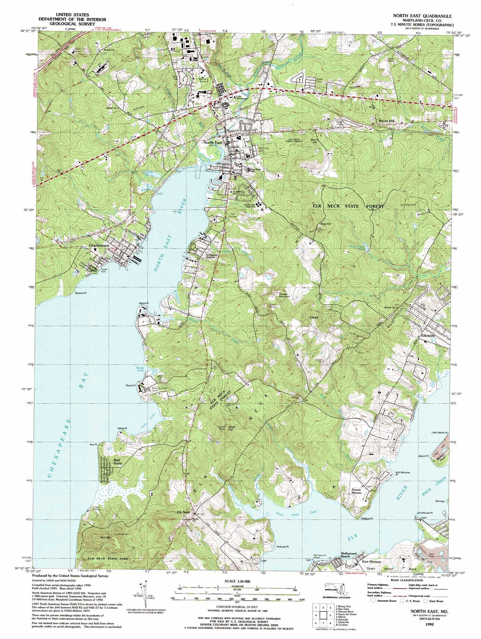
USGS Topo Quad 39075e8 - 1:24,000 scale
| Topo Map Name: | North East |
| USGS Topo Quad ID: | 39075e8 |
| Print Size: | ca. 21 1/4" wide x 27" high |
| Southeast Coordinates: | 39.5° N latitude / 75.875° W longitude |
| Map Center Coordinates: | 39.5625° N latitude / 75.9375° W longitude |
| U.S. State: | MD |
| Filename: | o39075e8.jpg |
| Download Map JPG Image: | North East topo map 1:24,000 scale |
| Map Type: | Topographic |
| Topo Series: | 7.5´ |
| Map Scale: | 1:24,000 |
| Source of Map Images: | United States Geological Survey (USGS) |
| Alternate Map Versions: |
North East MD 1953, updated 1955 Download PDF Buy paper map North East MD 1953, updated 1968 Download PDF Buy paper map North East MD 1953, updated 1971 Download PDF Buy paper map North East MD 1953, updated 1972 Download PDF Buy paper map North East MD 1953, updated 1991 Download PDF Buy paper map North East MD 1992, updated 1993 Download PDF Buy paper map North East MD 2011 Download PDF Buy paper map North East MD 2014 Download PDF Buy paper map North East MD 2016 Download PDF Buy paper map |
1:24,000 Topo Quads surrounding North East
Wakefield |
Kirkwood |
Oxford |
West Grove |
Kennett Square |
Conowingo Dam |
Rising Sun |
Bay View |
Newark West |
Newark East |
Aberdeen |
Havre De Grace |
North East |
Elkton |
Saint Georges |
Perryman |
Spesutie |
Earleville |
Cecilton |
Middletown |
Hanesville |
Betterton |
Galena |
Millington |
Clayton |
> Back to 39075e1 at 1:100,000 scale
> Back to 39074a1 at 1:250,000 scale
> Back to U.S. Topo Maps home
North East topo map: Gazetteer
North East: Airports
Weed Airport elevation 18m 59′North East: Bays
Cara Cove elevation 0m 0′Piney Creek Cove elevation 0m 0′
Sandy Cove elevation 0m 0′
North East: Beaches
Roachs Shore elevation -1m -4′North East: Capes
Bull Minnow Point elevation 0m 0′Coulters Point elevation 0m 0′
Courthouse Point elevation 3m 9′
Elk Neck elevation 18m 59′
Hance Point elevation 1m 3′
Hylands Point elevation 1m 3′
Oldfield Point elevation 1m 3′
Red Point elevation 0m 0′
Roach Point elevation 3m 9′
Seneca Point elevation 2m 6′
Welch Point elevation 3m 9′
White Point elevation 2m 6′
North East: Crossings
Elk Ferry (historical) elevation 0m 0′North East: Forests
Elk Neck State Forest elevation 38m 124′North East: Parks
Charlestown Athletic Complex elevation 10m 32′Charlestown Historic District elevation 9m 29′
Courthouse Point Managed Hunting Area elevation 12m 39′
Elk Neck State Park elevation 43m 141′
North East Community Park elevation 2m 6′
North East Little League Park elevation 59m 193′
North East: Populated Places
Altamont Place elevation 17m 55′Bacon Hill elevation 27m 88′
Cedar Hill elevation 13m 42′
Charlestown elevation 11m 36′
Charlestown Manor Beach elevation 0m 0′
Cool Springs Park elevation 26m 85′
De La Plaine Manor elevation 15m 49′
Elk Neck elevation 57m 187′
Elk Ranch Park elevation 20m 65′
Elk River Estates elevation 24m 78′
Elkmore elevation 22m 72′
Green Haven elevation 20m 65′
Hance Point Estates elevation 5m 16′
Harbor View elevation 8m 26′
Hollywood Beach elevation 4m 13′
Indian Falls elevation 25m 82′
Joy Haven elevation 51m 167′
La Plaine Estates elevation 54m 177′
Lakeside Park South elevation 38m 124′
Laurel Chase Manor elevation 42m 137′
Leslie elevation 54m 177′
North Bluff elevation 6m 19′
North East elevation 5m 16′
North East Harbor elevation 8m 26′
North East Isles elevation 9m 29′
North East Park elevation 25m 82′
Northeast Heights elevation 5m 16′
Old Field Point elevation 24m 78′
Oldfield Acres elevation 16m 52′
Pembray elevation 12m 39′
Pine Hills elevation 34m 111′
Port Herman elevation 4m 13′
Prestige Village elevation 22m 72′
Quails Nest elevation 78m 255′
Red Point elevation 15m 49′
Saint Johns Manor elevation 15m 49′
Saint Johns Vista elevation 22m 72′
Timberbrook elevation 29m 95′
Town Commons elevation 6m 19′
Villages of Elk Neck elevation 29m 95′
Westover elevation 9m 29′
Westover Mobile Home Park elevation 8m 26′
Whispering Pines Mobile Home Park elevation 34m 111′
Wilwon Woods elevation 60m 196′
North East: Post Offices
Charlestown Post Office elevation 6m 19′North East Post Office elevation 5m 16′
Port Herman Post Office (historical) elevation 4m 13′
North East: Reservoirs
Plum Creek Pond elevation 20m 65′North East: Streams
Bull Minnow Run elevation 8m 26′Ford Run elevation 2m 6′
Hance Point Creek elevation 4m 13′
Jones Creek elevation 0m 0′
Little North East Creek elevation 9m 29′
Muddy Creek elevation 0m 0′
North East Creek elevation 9m 29′
North East Creek elevation 9m 29′
Piney Creek elevation 1m 3′
Stony Run elevation 0m 0′
North East: Summits
Bacon Hill elevation 60m 196′Black Hill elevation 83m 272′
Bull Mountain elevation 72m 236′
Hog Hill elevation 82m 269′
Rhodes Mountain elevation 77m 252′
North East digital topo map on disk
Buy this North East topo map showing relief, roads, GPS coordinates and other geographical features, as a high-resolution digital map file on DVD:
Atlantic Coast (NY, NJ, PA, DE, MD, VA, NC)
Buy digital topo maps: Atlantic Coast (NY, NJ, PA, DE, MD, VA, NC)
 map DVD")