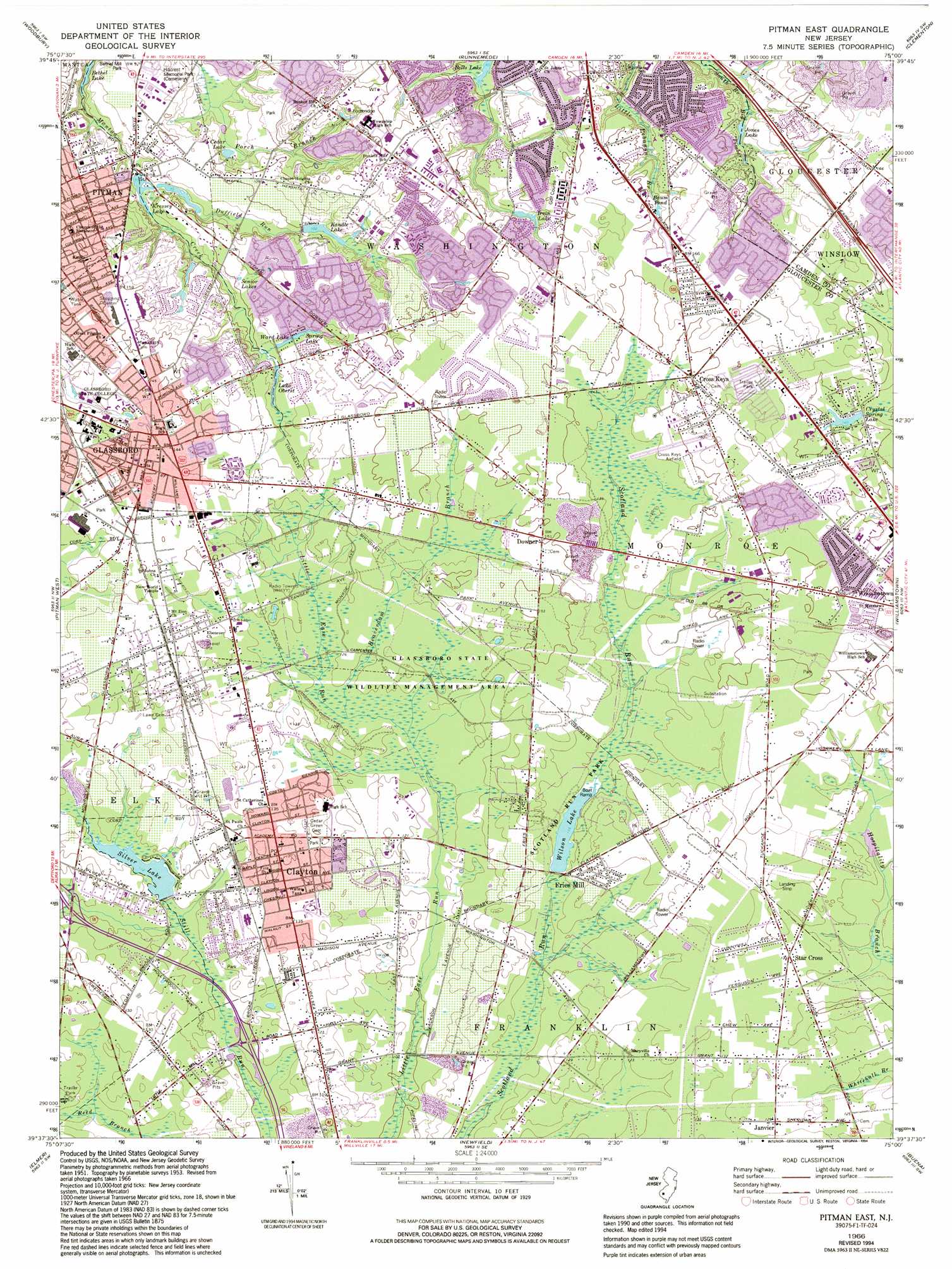
Pitman East Topo Map New Jersey
To zoom in, hover over the map of Pitman East
USGS Topo Quad 39075f1 - 1:24,000 scale
| Topo Map Name: | Pitman East |
| USGS Topo Quad ID: | 39075f1 |
| Print Size: | ca. 21 1/4" wide x 27" high |
| Southeast Coordinates: | 39.625° N latitude / 75° W longitude |
| Map Center Coordinates: | 39.6875° N latitude / 75.0625° W longitude |
| U.S. State: | NJ |
| Filename: | o39075f1.jpg |
| Download Map JPG Image: | Pitman East topo map 1:24,000 scale |
| Map Type: | Topographic |
| Topo Series: | 7.5´ |
| Map Scale: | 1:24,000 |
| Source of Map Images: | United States Geological Survey (USGS) |
| Alternate Map Versions: |
Pitman East NJ 1953, updated 1954 Download PDF Buy paper map Pitman East NJ 1966, updated 1968 Download PDF Buy paper map Pitman East NJ 1966, updated 1982 Download PDF Buy paper map Pitman East NJ 1966, updated 1994 Download PDF Buy paper map Pitman East NJ 2011 Download PDF Buy paper map Pitman East NJ 2014 Download PDF Buy paper map Pitman East NJ 2016 Download PDF Buy paper map |
1:24,000 Topo Quads surrounding Pitman East
Lansdowne |
Philadelphia |
Camden |
Moorestown |
Mount Holly |
Bridgeport |
Woodbury |
Runnemede |
Clementon |
Medford Lakes |
Woodstown |
Pitman West |
Pitman East |
Williamstown |
Hammonton |
Alloway |
Elmer |
Newfield |
Buena |
Newtonville |
Shiloh |
Bridgeton |
Millville |
Five Points |
Dorothy |
> Back to 39075e1 at 1:100,000 scale
> Back to 39074a1 at 1:250,000 scale
> Back to U.S. Topo Maps home
Pitman East topo map: Gazetteer
Pitman East: Airports
Cross Keys elevation 46m 150′Cross Keys Airport elevation 44m 144′
Downer Airstrip elevation 36m 118′
Reeder Airport elevation 44m 144′
Pitman East: Dams
Crystal Spring Lake Dam elevation 42m 137′Fries Mill Dam elevation 34m 111′
Silver Lake Dam elevation 34m 111′
Pitman East: Lakes
Baum Pond elevation 42m 137′Jones Lake elevation 36m 118′
Senior Lakes elevation 30m 98′
Wilson Lake elevation 34m 111′
Pitman East: Parks
Glassboro Fish and Wildlife Management Area elevation 37m 121′Pitman East: Populated Places
Clayton elevation 39m 127′Cross Keys elevation 46m 150′
Dilkesboro elevation 39m 127′
Downer elevation 45m 147′
Fries Mill elevation 39m 127′
Glassboro elevation 44m 144′
Harding elevation 40m 131′
Janvier elevation 39m 127′
Robanna elevation 48m 157′
Star Cross elevation 41m 134′
Whitman Square elevation 42m 137′
Pitman East: Reservoirs
Cedar Lake elevation 20m 65′Crystal Spring Lake elevation 42m 137′
Irvin Lake elevation 41m 134′
Kandle Lake elevation 31m 101′
Kressey Lake elevation 22m 72′
Lake Oberst elevation 33m 108′
Silver Lake elevation 34m 111′
Spring Lake elevation 36m 118′
Ward Lake elevation 34m 111′
Pitman East: Streams
Beaverdam Branch elevation 36m 118′Duffield Run elevation 22m 72′
Slab Bridge Branch elevation 33m 108′
Pitman East digital topo map on disk
Buy this Pitman East topo map showing relief, roads, GPS coordinates and other geographical features, as a high-resolution digital map file on DVD:
Atlantic Coast (NY, NJ, PA, DE, MD, VA, NC)
Buy digital topo maps: Atlantic Coast (NY, NJ, PA, DE, MD, VA, NC)
 map DVD")