Penns Grove Topo Map New Jersey
To zoom in, hover over the map of Penns Grove
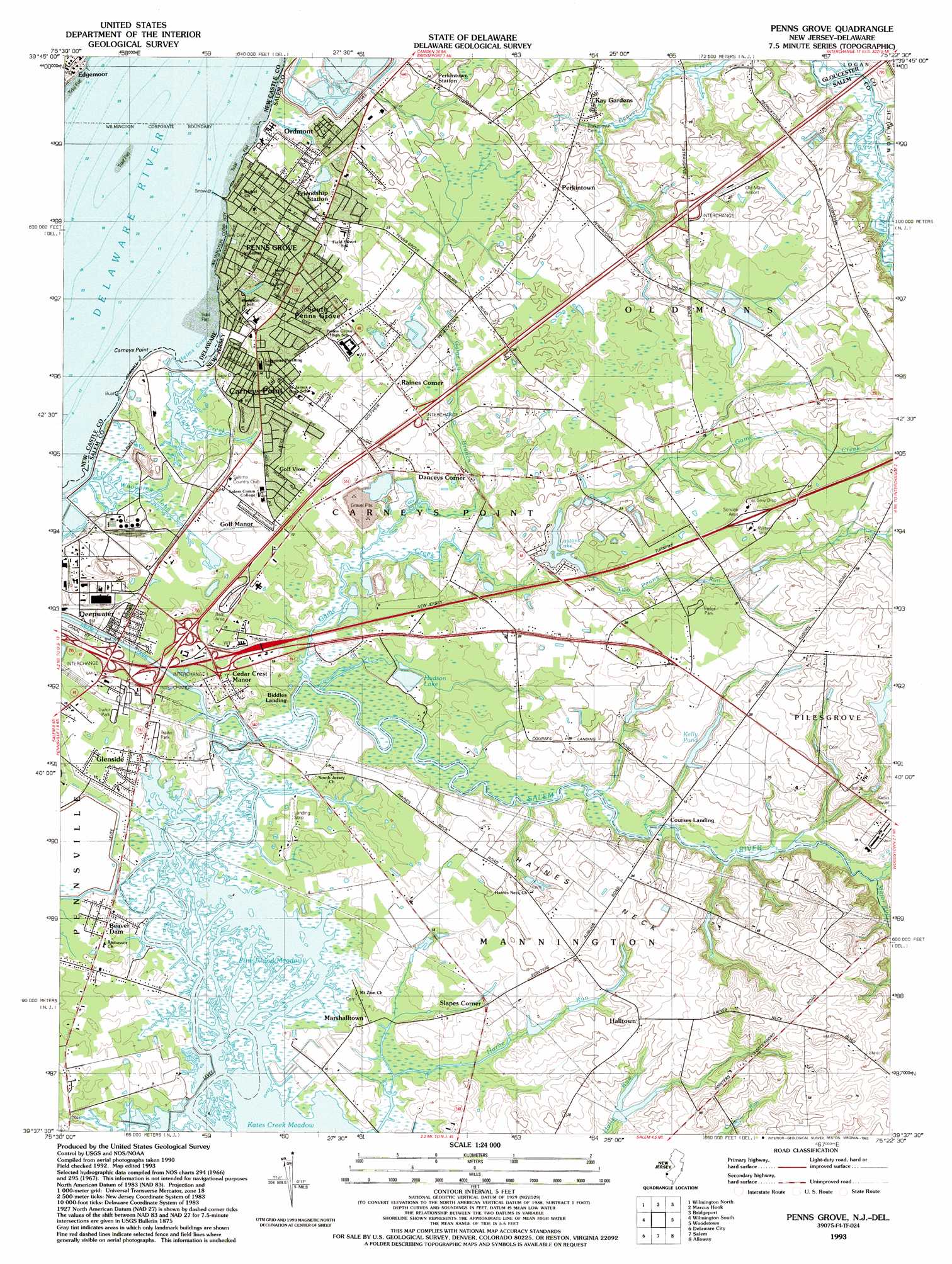
USGS Topo Quad 39075f4 - 1:24,000 scale
| Topo Map Name: | Penns Grove |
| USGS Topo Quad ID: | 39075f4 |
| Print Size: | ca. 21 1/4" wide x 27" high |
| Southeast Coordinates: | 39.625° N latitude / 75.375° W longitude |
| Map Center Coordinates: | 39.6875° N latitude / 75.4375° W longitude |
| U.S. States: | NJ, DE |
| Filename: | o39075f4.jpg |
| Download Map JPG Image: | Penns Grove topo map 1:24,000 scale |
| Map Type: | Topographic |
| Topo Series: | 7.5´ |
| Map Scale: | 1:24,000 |
| Source of Map Images: | United States Geological Survey (USGS) |
| Alternate Map Versions: |
Penns Grove NJ 1951 Download PDF Buy paper map Penns Grove NJ 1967, updated 1969 Download PDF Buy paper map Penns Grove NJ 1967, updated 1987 Download PDF Buy paper map Penns Grove NJ 1993, updated 1993 Download PDF Buy paper map Penns Grove NJ 1995, updated 1999 Download PDF Buy paper map Penns Grove NJ 2011 Download PDF Buy paper map Penns Grove NJ 2014 Download PDF Buy paper map Penns Grove NJ 2016 Download PDF Buy paper map |
1:24,000 Topo Quads surrounding Penns Grove
Unionville |
West Chester |
Media |
Lansdowne |
Philadelphia |
Kennett Square |
Wilmington North |
Marcus Hook |
Bridgeport |
Woodbury |
Newark East |
Wilmington South |
Penns Grove |
Woodstown |
Pitman West |
Saint Georges |
Delaware City |
Salem |
Alloway |
Elmer |
Middletown |
Taylors Bridge |
Canton |
Shiloh |
Bridgeton |
> Back to 39075e1 at 1:100,000 scale
> Back to 39074a1 at 1:250,000 scale
> Back to U.S. Topo Maps home
Penns Grove topo map: Gazetteer
Penns Grove: Airports
Deepwater Heliport elevation 2m 6′Halltown elevation 9m 29′
Old Mans Airport elevation 12m 39′
Penns Grove: Bars
Cherry Island Flats elevation 0m 0′Penns Grove: Bays
Helms Cove elevation 0m 0′Helms Cove elevation 0m 0′
Penns Grove: Canals
Salem Canal elevation 0m 0′Penns Grove: Capes
Carneys Point elevation 1m 3′Haines Neck elevation 10m 32′
Penns Grove: Crossings
Interchange 1 elevation 6m 19′Interchange 1 elevation 6m 19′
Interchange 1A elevation 5m 16′
Interchange 1B elevation 3m 9′
Interchange 1C elevation 7m 22′
Interchange 2 elevation 3m 9′
Interchange 2A elevation 3m 9′
Interchange 2B and 2C elevation 4m 13′
Interchange 4 elevation 6m 19′
Interchange 7 elevation 8m 26′
Penns Grove: Dams
Kelly Dam elevation 5m 16′Penns Grove: Lakes
Kates Creek Meadow elevation 0m 0′Penns Grove: Populated Places
Beaver Dam elevation 1m 3′Biddles Landing elevation 3m 9′
Carneys Point elevation 3m 9′
Cedar Crest Manor elevation 6m 19′
Courses Landing elevation 3m 9′
Danceys Corner elevation 4m 13′
Deepwater elevation 3m 9′
Friendship Station elevation 6m 19′
Glenside elevation 1m 3′
Golf Manor elevation 4m 13′
Golf View elevation 3m 9′
Halltown elevation 11m 36′
Kay Gardens elevation 4m 13′
Marshalltown elevation 1m 3′
Ordmont elevation 5m 16′
Penns Grove elevation 3m 9′
Perkintown elevation 9m 29′
Raines Corner elevation 6m 19′
Slapes Corner elevation 4m 13′
South Penns Grove elevation 6m 19′
Penns Grove: Reservoirs
Hudson Lake elevation 1m 3′Kelly Pond elevation 5m 16′
Laytons Lake elevation 3m 9′
Penns Grove: Streams
Game Branch elevation 0m 0′Game Creek elevation 1m 3′
Hanby Creek elevation 0m 0′
Horne Run elevation 1m 3′
Major Run elevation 0m 0′
Two Penny Run elevation 3m 9′
Whooping John Creek elevation 3m 9′
Penns Grove: Swamps
Pine Island Meadow elevation 1m 3′Penns Grove digital topo map on disk
Buy this Penns Grove topo map showing relief, roads, GPS coordinates and other geographical features, as a high-resolution digital map file on DVD:
Atlantic Coast (NY, NJ, PA, DE, MD, VA, NC)
Buy digital topo maps: Atlantic Coast (NY, NJ, PA, DE, MD, VA, NC)
 map DVD")