Wilmington South Topo Map Delaware
To zoom in, hover over the map of Wilmington South
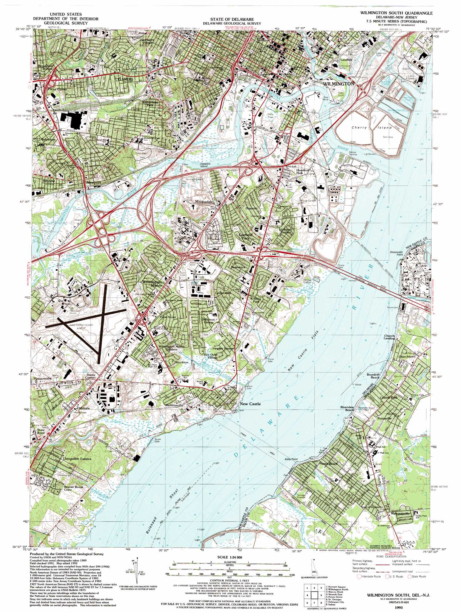
USGS Topo Quad 39075f5 - 1:24,000 scale
| Topo Map Name: | Wilmington South |
| USGS Topo Quad ID: | 39075f5 |
| Print Size: | ca. 21 1/4" wide x 27" high |
| Southeast Coordinates: | 39.625° N latitude / 75.5° W longitude |
| Map Center Coordinates: | 39.6875° N latitude / 75.5625° W longitude |
| U.S. States: | DE, NJ |
| Filename: | o39075f5.jpg |
| Download Map JPG Image: | Wilmington South topo map 1:24,000 scale |
| Map Type: | Topographic |
| Topo Series: | 7.5´ |
| Map Scale: | 1:24,000 |
| Source of Map Images: | United States Geological Survey (USGS) |
| Alternate Map Versions: |
Wilmington South DE 1948, updated 1952 Download PDF Buy paper map Wilmington South DE 1948, updated 1961 Download PDF Buy paper map Wilmington South DE 1967, updated 1969 Download PDF Buy paper map Wilmington South DE 1967, updated 1970 Download PDF Buy paper map Wilmington South DE 1967, updated 1987 Download PDF Buy paper map Wilmington South DE 1993, updated 1993 Download PDF Buy paper map Wilmington South DE 1997, updated 2000 Download PDF Buy paper map Wilmington South DE 2011 Download PDF Buy paper map Wilmington South DE 2014 Download PDF Buy paper map Wilmington South DE 2016 Download PDF Buy paper map |
1:24,000 Topo Quads surrounding Wilmington South
Coatesville |
Unionville |
West Chester |
Media |
Lansdowne |
West Grove |
Kennett Square |
Wilmington North |
Marcus Hook |
Bridgeport |
Newark West |
Newark East |
Wilmington South |
Penns Grove |
Woodstown |
Elkton |
Saint Georges |
Delaware City |
Salem |
Alloway |
Cecilton |
Middletown |
Taylors Bridge |
Canton |
Shiloh |
> Back to 39075e1 at 1:100,000 scale
> Back to 39074a1 at 1:250,000 scale
> Back to U.S. Topo Maps home
Wilmington South topo map: Gazetteer
Wilmington South: Airports
Deepwater Station Heliport elevation 0m 0′New Castle Airport elevation 22m 72′
Wilmington South: Bars
New Castle Flats elevation 0m 0′Wilmington South: Bays
Travis Cove elevation 0m 0′Wilmington South: Beaches
Deemers Beach elevation 0m 0′Deemers Beach elevation 0m 0′
Wilmington South: Bridges
Delaware Memorial Bridges elevation 0m 0′Delaware Memorial Bridges elevation 0m 0′
Wilmington South: Canals
Broad Dyke Canal elevation 1m 3′Lobdell Canal elevation 0m 0′
Magazine Ditch elevation 0m 0′
Wilmington South: Capes
Cedar Point elevation 1m 3′Crane Hook (historical) elevation 2m 6′
Deepwater Point elevation 1m 3′
Dutch Neck elevation 12m 39′
Kelly Point elevation 1m 3′
Pigeon Point elevation 0m 0′
Wilmington South: Channels
Cherry Island Range elevation 0m 0′Deepwater Point Range elevation 0m 0′
Wilmington South: Crossings
Interchange 1 elevation 4m 13′Interchange 2 elevation 3m 9′
Interchange 3 elevation 5m 16′
Interchange 5 elevation 7m 22′
Interchange 5A elevation 3m 9′
Interchange 5B elevation 4m 13′
Interchange 5C elevation 3m 9′
Interchange 6 elevation 7m 22′
Wilmington South: Dams
Pea Patch Island Dike elevation 0m 0′Wilmington South: Guts
Gambles Gut elevation 0m 0′The Dyke elevation 1m 3′
Wilmington South: Islands
Cherry Island elevation 16m 52′Coopers Island elevation 0m 0′
Wilmington South: Parks
Banning Park elevation 9m 29′Battery Park elevation 3m 9′
Biden Park elevation 30m 98′
Brown Park elevation 4m 13′
Canby Park elevation 15m 49′
Christina Park elevation 3m 9′
Clayton Park elevation 45m 147′
Compton Park elevation 9m 29′
Delamore Park elevation 21m 68′
Eden Park elevation 5m 16′
Fort Christina Park elevation 3m 9′
Kirkwood Park elevation 5m 16′
Llangollen Estates Park elevation 9m 29′
New Castle Historic District elevation 7m 22′
Ommelander Park elevation 11m 36′
Rodney Square elevation 30m 98′
Supawna Meadows National Wildlife Refuge elevation 1m 3′
The Green elevation 7m 22′
Wilmington South: Populated Places
Alban Park elevation 20m 65′Ashley elevation 23m 75′
Ashley Heights elevation 3m 9′
Avalon elevation 26m 85′
Basin Corner elevation 23m 75′
Bayview Manor elevation 11m 36′
Beaver Brook Apartments elevation 14m 45′
Belmoor elevation 24m 78′
Belvidere elevation 21m 68′
Bestfield elevation 21m 68′
Boxwood elevation 30m 98′
Brookland Terrace elevation 37m 121′
Buttonwood elevation 4m 13′
Canby Park Estates elevation 25m 82′
Castle Apartments elevation 15m 49′
Castle Hills elevation 16m 52′
Cedar Heights elevation 20m 65′
Central Park elevation 3m 9′
Champlin Village elevation 22m 72′
Chelsea Estates elevation 17m 55′
Chelsea Estates elevation 16m 52′
Christiana Acres elevation 2m 6′
Church Landing elevation 3m 9′
Churchtown elevation 2m 6′
Claridge Court elevation 6m 19′
Clearfield elevation 19m 62′
Clearview Manor elevation 20m 65′
Cleland Heights elevation 33m 108′
Collins Park elevation 9m 29′
Colonial Heights elevation 40m 131′
Colonial Village Apartments elevation 12m 39′
Colony Hills elevation 4m 13′
Delaware Junction elevation 3m 9′
Dobbinsville elevation 4m 13′
Dunleith elevation 17m 55′
Duross Heights elevation 17m 55′
East Minquadale elevation 22m 72′
Eden Park Gardens elevation 4m 13′
Elliots Addition elevation 32m 104′
Elmhurst elevation 29m 95′
Elsmere elevation 31m 101′
Farnhurst elevation 12m 39′
Fern Hook elevation 21m 68′
Forest Brook Glen elevation 11m 36′
Forest Park elevation 23m 75′
Fredericks Addition elevation 29m 95′
Garfield Park elevation 20m 65′
Gordy Estates elevation 25m 82′
Hamilton Park elevation 3m 9′
Hares Corner elevation 20m 65′
Hayden Park elevation 2m 6′
Hazeldell elevation 4m 13′
Holloway Terrace elevation 12m 39′
Idela elevation 24m 78′
Jefferson Farms elevation 6m 19′
Keystone elevation 28m 91′
Lancaster Village elevation 35m 114′
Landenberg Junction elevation 26m 85′
Landers Park elevation 24m 78′
Landlith elevation 3m 9′
Latimer Estates elevation 29m 95′
Leedon Estates elevation 18m 59′
Liberty elevation 25m 82′
Llangollen Estates elevation 15m 49′
Lyndalia elevation 13m 42′
Lynford elevation 23m 75′
Mahoneyville elevation 3m 9′
Manor Park elevation 22m 72′
Manor Park Apartments elevation 21m 68′
Masonicville elevation 24m 78′
Mayview Manor elevation 14m 45′
Middleboro Crest elevation 24m 78′
Middleboro East elevation 3m 9′
Middleboro Manor elevation 16m 52′
Midvale elevation 18m 59′
Midvalf elevation 19m 62′
Millside elevation 3m 9′
Minquadale elevation 20m 65′
Minquadale Trailer Village elevation 22m 72′
New Castle elevation 3m 9′
Newport elevation 10m 32′
Newport Heights elevation 10m 32′
Oakmont elevation 20m 65′
Overview Gardens elevation 7m 22′
Penn Acres elevation 18m 59′
Penn Acres South elevation 17m 55′
Penns Beach elevation 2m 6′
Pennsville elevation 3m 9′
Pleasant Hills elevation 7m 22′
Prices Corner elevation 35m 114′
Rambleton Acres elevation 15m 49′
Richardson Park elevation 24m 78′
Riveredge Park elevation 7m 22′
Rogers Corners elevation 6m 19′
Rogers Manor elevation 2m 6′
Rose Hill Gardens elevation 19m 62′
Rosegate elevation 9m 29′
Roselle Terrace elevation 36m 118′
Saienni Farms elevation 15m 49′
Scarborough Park elevation 16m 52′
Silverbrook Gardens elevation 30m 98′
Silview elevation 9m 29′
Simonds Gardens elevation 11m 36′
South Wilmington elevation 3m 9′
Stockton elevation 9m 29′
Stony Crest elevation 45m 147′
Swanwyck elevation 12m 39′
Swanwyck Estates elevation 18m 59′
Swanwyck Gardens elevation 23m 75′
Tuxedo Park elevation 14m 45′
Washington Park elevation 7m 22′
West Minquadale elevation 15m 49′
Westview elevation 17m 55′
Willow Run elevation 34m 111′
Wilmington elevation 28m 91′
Wilmington Manor elevation 18m 59′
Wilmington Manor Gardens elevation 6m 19′
Wood Wards Addition elevation 31m 101′
Woodcrest elevation 24m 78′
Woodland elevation 40m 131′
Woodland Park elevation 33m 108′
Wilmington South: Post Offices
Lancaster Avenue Station Post Office elevation 39m 127′New Castle Post Office elevation 4m 13′
Wilmington South: Reservoirs
New Castle Reservoir elevation 24m 78′Wilmington South: Streams
Army Creek elevation 1m 3′Brandywine Creek elevation 0m 0′
Chestnut Run elevation 23m 75′
Christina River elevation 0m 0′
Hoppemense Creek elevation 0m 0′
Little Mill Creek elevation 0m 0′
Miles Creek elevation 1m 3′
Nonesuch Creek elevation 1m 3′
Shellpot Creek elevation 0m 0′
Stonebank Creek elevation 1m 3′
White Clay Creek elevation 0m 0′
Wilmington South: Swamps
Cherry Island Marsh elevation 9m 29′Fern Hook Marsh elevation 2m 6′
Newport Marsh elevation 1m 3′
Wilmington South digital topo map on disk
Buy this Wilmington South topo map showing relief, roads, GPS coordinates and other geographical features, as a high-resolution digital map file on DVD:
Atlantic Coast (NY, NJ, PA, DE, MD, VA, NC)
Buy digital topo maps: Atlantic Coast (NY, NJ, PA, DE, MD, VA, NC)
 map DVD")