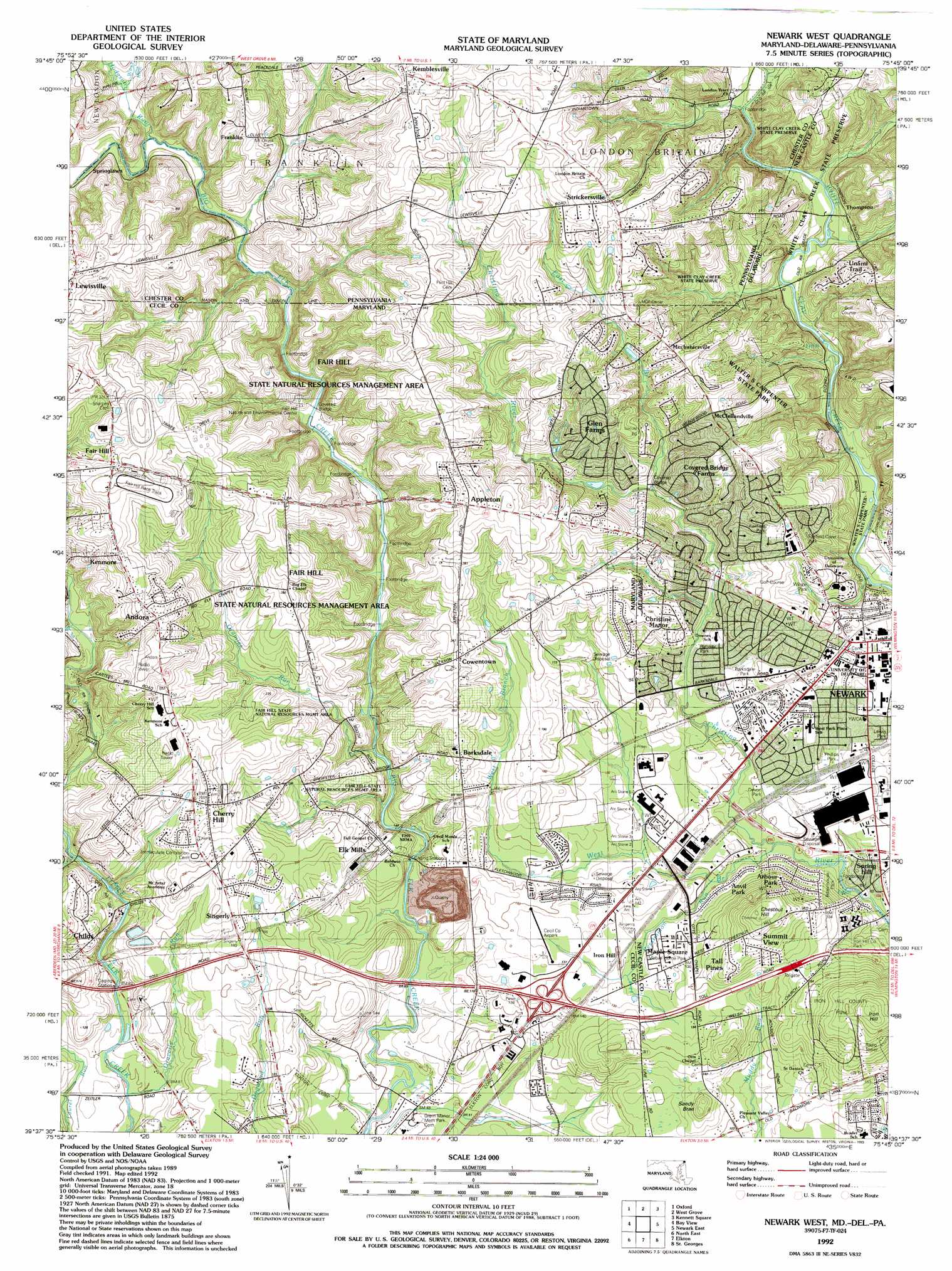
Newark West Topo Map Maryland
To zoom in, hover over the map of Newark West
USGS Topo Quad 39075f7 - 1:24,000 scale
| Topo Map Name: | Newark West |
| USGS Topo Quad ID: | 39075f7 |
| Print Size: | ca. 21 1/4" wide x 27" high |
| Southeast Coordinates: | 39.625° N latitude / 75.75° W longitude |
| Map Center Coordinates: | 39.6875° N latitude / 75.8125° W longitude |
| U.S. States: | MD, DE, PA |
| Filename: | o39075f7.jpg |
| Download Map JPG Image: | Newark West topo map 1:24,000 scale |
| Map Type: | Topographic |
| Topo Series: | 7.5´ |
| Map Scale: | 1:24,000 |
| Source of Map Images: | United States Geological Survey (USGS) |
| Alternate Map Versions: |
Newark West DE 1953, updated 1954 Download PDF Buy paper map Newark West DE 1953, updated 1954 Download PDF Buy paper map Newark West DE 1953, updated 1964 Download PDF Buy paper map Newark West DE 1953, updated 1972 Download PDF Buy paper map Newark West DE 1953, updated 1984 Download PDF Buy paper map Newark West DE 1953, updated 1991 Download PDF Buy paper map Newark West DE 1992, updated 1993 Download PDF Buy paper map Newark West DE 1992, updated 1993 Download PDF Buy paper map Newark West DE 1992, updated 1997 Download PDF Buy paper map Newark West DE 2011 Download PDF Buy paper map Newark West DE 2014 Download PDF Buy paper map Newark West DE 2016 Download PDF Buy paper map |
1:24,000 Topo Quads surrounding Newark West
Gap |
Parkesburg |
Coatesville |
Unionville |
West Chester |
Kirkwood |
Oxford |
West Grove |
Kennett Square |
Wilmington North |
Rising Sun |
Bay View |
Newark West |
Newark East |
Wilmington South |
Havre De Grace |
North East |
Elkton |
Saint Georges |
Delaware City |
Spesutie |
Earleville |
Cecilton |
Middletown |
Taylors Bridge |
> Back to 39075e1 at 1:100,000 scale
> Back to 39074a1 at 1:250,000 scale
> Back to U.S. Topo Maps home
Newark West topo map: Gazetteer
Newark West: Airports
Cecil County Airpark elevation 40m 131′Newark West: Areas
The Wedge elevation 59m 193′Newark West: Bridges
Big Elk Creek Covered Bridge (historical) elevation 52m 170′Childs Pony Truss Bridge elevation 33m 108′
Elk Forge Bridge (historical) elevation 19m 62′
Newark West: Crossings
Interchange 9 elevation 40m 131′Newark West: Parks
Barksdale Park elevation 39m 127′Coverdale Park elevation 36m 118′
Devon Park elevation 32m 104′
Dickey Park elevation 39m 127′
Fair Hill Natural Resource Management Area elevation 45m 147′
Fair Hill State Natural Resources Management Area elevation 64m 209′
Fairfield Crest Park elevation 49m 160′
Fairfield Park elevation 68m 223′
Hall Park elevation 36m 118′
Iron Hill County Park elevation 82m 269′
Phillips Park elevation 30m 98′
Rahway Park elevation 34m 111′
Rittenhouse Park elevation 26m 85′
Rittenhouse Park elevation 27m 88′
Walter S Carpenter State Park elevation 84m 275′
West Branch Community Park elevation 36m 118′
White Clay Creek Preserve elevation 77m 252′
White Clay Creek State Park elevation 33m 108′
Newark West: Populated Places
Academy Hills elevation 67m 219′Amaranth elevation 91m 298′
Andora elevation 111m 364′
Andora Acres elevation 104m 341′
Appleton elevation 102m 334′
Appleton Acres elevation 103m 337′
Appleton Glen elevation 88m 288′
Arbour Park elevation 57m 187′
Bank (historical) elevation 40m 131′
Barksdale elevation 64m 209′
Barksdale Farms elevation 54m 177′
Bel Hill (historical) elevation 13m 42′
Boot Hill elevation 73m 239′
Brewster Heights elevation 55m 180′
Bristle Knoll elevation 90m 295′
Cecil Manor elevation 46m 150′
Cherry Hill elevation 44m 144′
Cherry Hill elevation 71m 232′
Cherry Wood elevation 59m 193′
Childs elevation 48m 157′
Chippendale elevation 80m 262′
Christina Manor elevation 49m 160′
College Park elevation 36m 118′
Colonial Acres elevation 36m 118′
Cottage Mill elevation 21m 68′
Covered Bridge Farms elevation 48m 157′
Cowentown elevation 72m 236′
Cristine Manor elevation 47m 154′
Devon elevation 32m 104′
El Paco Farms elevation 78m 255′
Elk Mills elevation 44m 144′
Everbreeze elevation 78m 255′
Fair Hill elevation 117m 383′
Fairfield elevation 63m 206′
Fairfield Crest elevation 51m 167′
Four Seasons elevation 33m 108′
Foxcatcher at Fair Hill elevation 125m 410′
Foxchase Manor elevation 104m 341′
Foxfield elevation 34m 111′
Franklin elevation 93m 305′
Gilpin Farms elevation 11m 36′
Glen Farms elevation 78m 255′
Glen Kyle elevation 76m 249′
Glen Westover elevation 100m 328′
Grand Meadows elevation 98m 321′
Greenridge elevation 91m 298′
Hidden Acres elevation 90m 295′
Hillcrest elevation 94m 308′
Hunting Hills elevation 39m 127′
Iron Hill elevation 37m 121′
Iron Hill elevation 58m 190′
Kemblesville elevation 126m 413′
Kenmore elevation 113m 370′
Lewisville elevation 130m 426′
Manchester Park elevation 59m 193′
McClellandville elevation 88m 288′
Meadowview elevation 40m 131′
Meadowview Park elevation 46m 150′
Mechanicsville elevation 89m 291′
Molitor Estates elevation 69m 226′
Newark elevation 92m 301′
Nonatum Mills elevation 24m 78′
Northminster at Fair Hill elevation 104m 341′
Nottingham Green elevation 36m 118′
Nottingham Manor elevation 58m 190′
Oakland elevation 52m 170′
Oakridge elevation 51m 167′
Oaktree Apartments elevation 39m 127′
Palm Springs Manor elevation 39m 127′
Silver Brook elevation 26m 85′
Singerly elevation 48m 157′
Springlawn elevation 80m 262′
Strickersville elevation 107m 351′
Summit View elevation 71m 232′
Surrey Ridge elevation 112m 367′
Tara elevation 61m 200′
Thabar elevation 90m 295′
The Highlands elevation 69m 226′
The Meadows at Elk Creek elevation 20m 65′
Thompson elevation 35m 114′
Top of the Wedge elevation 86m 282′
Wedge Hills elevation 70m 229′
Wedgewood Hills elevation 68m 223′
West Creek Village elevation 50m 164′
Winchester elevation 46m 150′
Winding Brook Village elevation 39m 127′
Newark West: Post Offices
Cherryhill Post Office (historical) elevation 66m 216′Childs Post Office elevation 44m 144′
Elk Mills Post Office elevation 45m 147′
Fairhill Post Office (historical) elevation 114m 374′
Newark West: Streams
Bogy Run elevation 23m 75′East Branch Christina River elevation 48m 157′
East Branch Laurel Run elevation 19m 62′
East Branch White Clay Creek elevation 36m 118′
Fairfield Run elevation 26m 85′
Gramies Run elevation 29m 95′
Gravelly Run elevation 15m 49′
Hodgson Run elevation 59m 193′
Lamborn Run elevation 30m 98′
Lost Stream elevation 23m 75′
Persimmon Run elevation 28m 91′
Ways Run elevation 67m 219′
West Branch Christina River elevation 24m 78′
West Branch Christina River elevation 25m 82′
West Branch Laurel Run elevation 19m 62′
Newark West: Summits
Chestnut Hill elevation 89m 291′Grays Hill elevation 61m 200′
Iron Hill elevation 101m 331′
Sandy Brae elevation 34m 111′
Sandy Bray elevation 52m 170′
Newark West digital topo map on disk
Buy this Newark West topo map showing relief, roads, GPS coordinates and other geographical features, as a high-resolution digital map file on DVD:
Atlantic Coast (NY, NJ, PA, DE, MD, VA, NC)
Buy digital topo maps: Atlantic Coast (NY, NJ, PA, DE, MD, VA, NC)
 map DVD")