Odenton Topo Map Maryland
To zoom in, hover over the map of Odenton
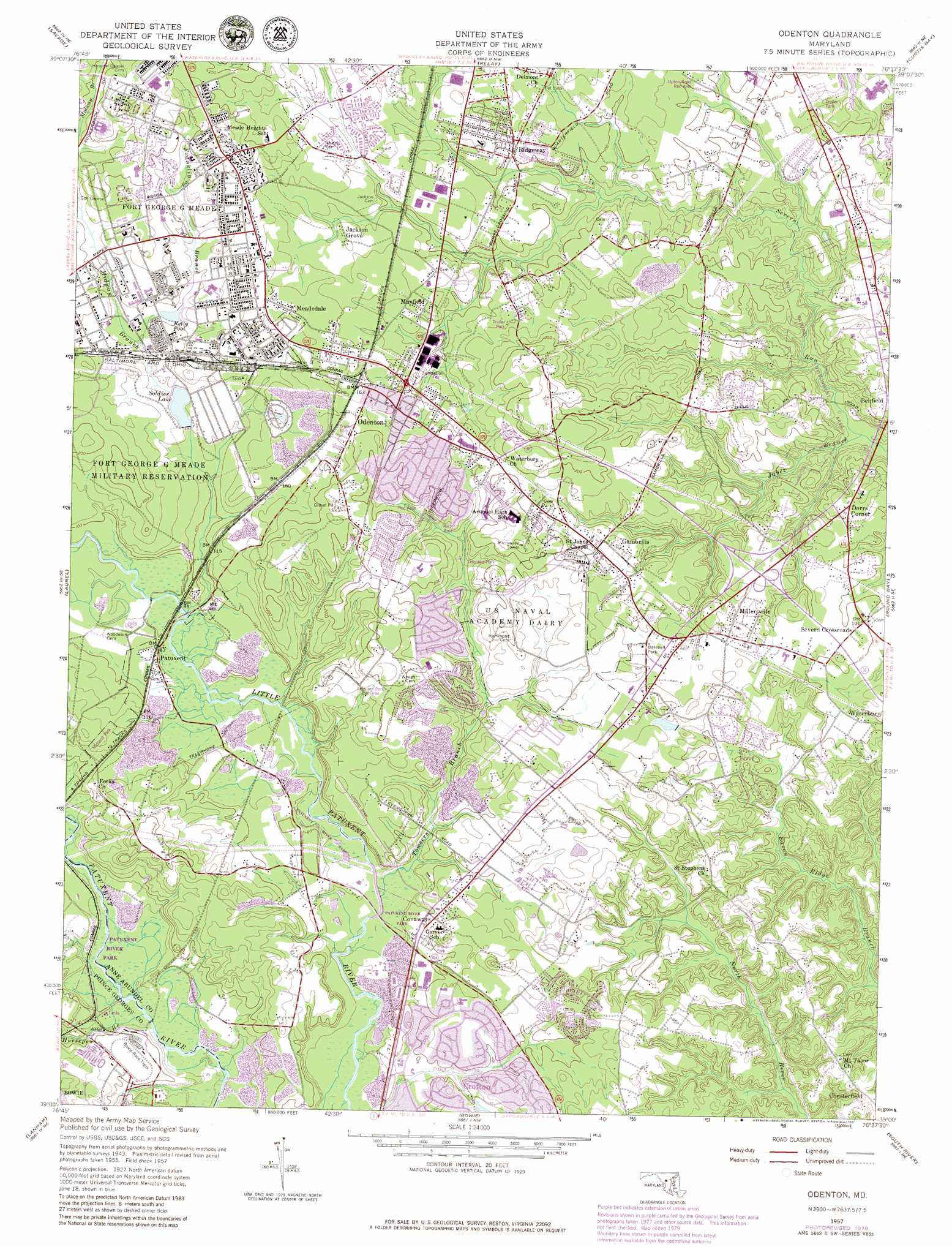
USGS Topo Quad 39076a6 - 1:24,000 scale
| Topo Map Name: | Odenton |
| USGS Topo Quad ID: | 39076a6 |
| Print Size: | ca. 21 1/4" wide x 27" high |
| Southeast Coordinates: | 39° N latitude / 76.625° W longitude |
| Map Center Coordinates: | 39.0625° N latitude / 76.6875° W longitude |
| U.S. State: | MD |
| Filename: | o39076a6.jpg |
| Download Map JPG Image: | Odenton topo map 1:24,000 scale |
| Map Type: | Topographic |
| Topo Series: | 7.5´ |
| Map Scale: | 1:24,000 |
| Source of Map Images: | United States Geological Survey (USGS) |
| Alternate Map Versions: |
Odenton MD 1949, updated 1953 Download PDF Buy paper map Odenton MD 1957, updated 1960 Download PDF Buy paper map Odenton MD 1957, updated 1965 Download PDF Buy paper map Odenton MD 1957, updated 1971 Download PDF Buy paper map Odenton MD 1957, updated 1972 Download PDF Buy paper map Odenton MD 1957, updated 1980 Download PDF Buy paper map Odenton MD 2011 Download PDF Buy paper map Odenton MD 2014 Download PDF Buy paper map Odenton MD 2016 Download PDF Buy paper map |
1:24,000 Topo Quads surrounding Odenton
Sykesville |
Ellicott City |
Baltimore West |
Baltimore East |
Middle River |
Clarksville |
Savage |
Relay |
Curtis Bay |
Sparrows Point |
Beltsville |
Laurel |
Odenton |
Round Bay |
Gibson Island |
Washington East |
Lanham |
Bowie |
South River |
Annapolis |
Anacostia |
Upper Marlboro |
Bristol |
Deale |
> Back to 39076a1 at 1:100,000 scale
> Back to 39076a1 at 1:250,000 scale
> Back to U.S. Topo Maps home
Odenton topo map: Gazetteer
Odenton: Crossings
Interchange 10 elevation 33m 108′Interchange 7 elevation 37m 121′
Odenton: Dams
Burba Lake Dam elevation 39m 127′Soldier Lake Dam elevation 34m 111′
Odenton: Lakes
Walking Fish Pond elevation 13m 42′Odenton: Parks
Crofton Park elevation 44m 144′Midland Park elevation 51m 167′
Odenton Park elevation 47m 154′
Odenton Park Recreation Area elevation 54m 177′
Patuxent Ponds Park elevation 20m 65′
Severn Run Natural Environment Area elevation 11m 36′
Towsers Branch Park elevation 37m 121′
Odenton: Populated Places
Academy Junction elevation 40m 131′Admiral (historical) elevation 42m 137′
Amberfield elevation 30m 98′
Andersons Corner elevation 41m 134′
Arundel Acres elevation 60m 196′
Arundel Mobile Village elevation 55m 180′
Arundel View elevation 62m 203′
Aurora Hills elevation 35m 114′
Baldwin Hills elevation 40m 131′
Baldwin Hills South elevation 29m 95′
Bells Mobile Home Park elevation 39m 127′
Blue Ridge at Crofton Meadows elevation 44m 144′
Bonaventure elevation 44m 144′
Bonnie Acres elevation 30m 98′
Brandy Farms elevation 42m 137′
Bretton Woods elevation 48m 157′
Cedarcroft elevation 23m 75′
Chapelgate elevation 69m 226′
Charing Cross elevation 38m 124′
Chase Hill elevation 52m 170′
Chesmar elevation 31m 101′
Chestnut Ridge elevation 43m 141′
Colony Ridge elevation 59m 193′
Conaways elevation 32m 104′
Courts of Crofton elevation 51m 167′
Crofton elevation 31m 101′
Crofton Commons elevation 31m 101′
Crofton Highlands elevation 45m 147′
Crofton Mews elevation 36m 118′
Crofton Park elevation 36m 118′
Crofton Square elevation 31m 101′
Crofton Village elevation 40m 131′
Crofton Village Green elevation 30m 98′
Derby Farms elevation 39m 127′
Devonshire elevation 39m 127′
Dorrs Corner elevation 39m 127′
Four Seasons Estates elevation 53m 173′
Gambrills elevation 46m 150′
Geraghty Village elevation 47m 154′
Grand View Park elevation 32m 104′
Hammond Park elevation 55m 180′
Harpers Mill elevation 33m 108′
Hidden Village elevation 61m 200′
Jackson Grove elevation 41m 134′
Kings Heights elevation 65m 213′
Kings Ransom elevation 65m 213′
Lions Gate elevation 46m 150′
Mallet Hill elevation 37m 121′
Maple Ridge elevation 66m 216′
Mayfield elevation 38m 124′
Meade Heights elevation 63m 206′
Meadedale elevation 49m 160′
Millersville elevation 47m 154′
Millersville Forest elevation 23m 75′
Millrace elevation 35m 114′
Mistwood elevation 56m 183′
New Cut Farms elevation 30m 98′
Oakdale elevation 27m 88′
Odenton elevation 47m 154′
Odenton Heights elevation 61m 200′
Odenton Park elevation 49m 160′
Orchard Gate at Piney Orchard elevation 66m 216′
Orchard Point at Piney Orchard elevation 62m 203′
Patuxent elevation 25m 82′
Piney Orchard elevation 73m 239′
Pioneer City elevation 46m 150′
Quarterfield Farms elevation 40m 131′
Reece Heights elevation 43m 141′
Riden elevation 57m 187′
Ridgeway elevation 30m 98′
Riedel Estates elevation 41m 134′
Rol-Park Trailer Village elevation 26m 85′
Saddle Ridge elevation 36m 118′
Saint Stephens Estates elevation 47m 154′
Scotts Manor elevation 67m 219′
Seven Oaks elevation 38m 124′
Severn Crossroads elevation 30m 98′
Severn Forest elevation 37m 121′
Severn Lea elevation 38m 124′
Shawnee Estates elevation 30m 98′
Spring Meadows elevation 44m 144′
Spruce Hill Estates elevation 39m 127′
Stillmeadow elevation 42m 137′
Stoney Hill elevation 48m 157′
Sunnyview Acres elevation 37m 121′
Tanager Forest elevation 34m 111′
The Courts at Piney Orchard elevation 67m 219′
The Courts of Four Seasons elevation 56m 183′
Villa Bella elevation 66m 216′
Villa Verdi elevation 53m 173′
Walden elevation 37m 121′
Warfield elevation 43m 141′
Waterbury elevation 26m 85′
Wedgewood Forest elevation 43m 141′
Wethersfield elevation 68m 223′
Windswept Estates elevation 36m 118′
Yorktown elevation 32m 104′
Odenton: Post Offices
Gambrills Post Office elevation 48m 157′Millersville Post Office elevation 26m 85′
Odenton Post Office elevation 51m 167′
Odenton: Reservoirs
18 Reservoir elevation 34m 111′Burba Lake elevation 42m 137′
Kelly Pool elevation 39m 127′
Soldier Lake elevation 34m 111′
Odenton: Streams
Franklin Branch elevation 36m 118′Horsepen Branch elevation 14m 45′
Jabez Branch elevation 2m 6′
Midway Branch elevation 22m 72′
Towsers Branch elevation 14m 45′
Odenton digital topo map on disk
Buy this Odenton topo map showing relief, roads, GPS coordinates and other geographical features, as a high-resolution digital map file on DVD:
Atlantic Coast (NY, NJ, PA, DE, MD, VA, NC)
Buy digital topo maps: Atlantic Coast (NY, NJ, PA, DE, MD, VA, NC)
 map DVD")