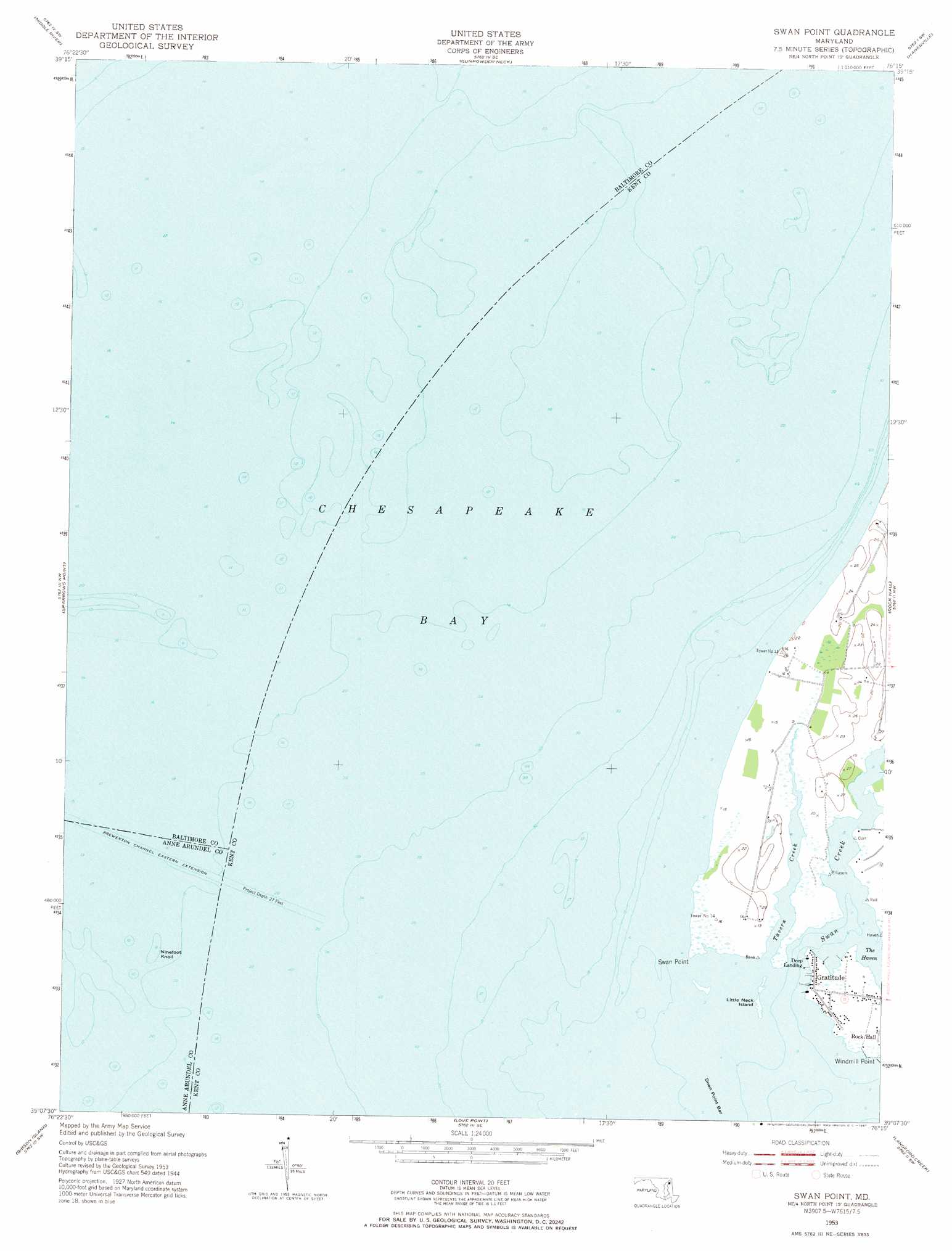
Swan Point Topo Map Maryland
To zoom in, hover over the map of Swan Point
USGS Topo Quad 39076b3 - 1:24,000 scale
| Topo Map Name: | Swan Point |
| USGS Topo Quad ID: | 39076b3 |
| Print Size: | ca. 21 1/4" wide x 27" high |
| Southeast Coordinates: | 39.125° N latitude / 76.25° W longitude |
| Map Center Coordinates: | 39.1875° N latitude / 76.3125° W longitude |
| U.S. State: | MD |
| Filename: | o39076b3.jpg |
| Download Map JPG Image: | Swan Point topo map 1:24,000 scale |
| Map Type: | Topographic |
| Topo Series: | 7.5´ |
| Map Scale: | 1:24,000 |
| Source of Map Images: | United States Geological Survey (USGS) |
| Alternate Map Versions: |
Swan Point MD 1953, updated 1955 Download PDF Buy paper map Swan Point MD 1953, updated 1967 Download PDF Buy paper map Swan Point MD 2011 Download PDF Buy paper map Swan Point MD 2014 Download PDF Buy paper map Swan Point MD 2016 Download PDF Buy paper map |
1:24,000 Topo Quads surrounding Swan Point
Towson |
White Marsh |
Edgewood |
Perryman |
Spesutie |
Baltimore East |
Middle River |
Gunpowder Neck |
Hanesville |
Betterton |
Curtis Bay |
Sparrows Point |
Swan Point |
Rock Hall |
Chestertown |
Round Bay |
Gibson Island |
Love Point |
Langford Creek |
Centreville |
South River |
Annapolis |
Kent Island |
Queenstown |
Wye Mills |
> Back to 39076a1 at 1:100,000 scale
> Back to 39076a1 at 1:250,000 scale
> Back to U.S. Topo Maps home
Swan Point topo map: Gazetteer
Swan Point: Bars
Ninefoot Knoll elevation 0m 0′Swan Point Bar elevation 0m 0′
Swan Point: Capes
Harts Point elevation 1m 3′Swan Point elevation 1m 3′
Windmill Point elevation 3m 9′
Swan Point: Channels
Brewerton Channel Eastern Extension elevation 0m 0′Swan Point: Islands
Little Neck Island elevation 0m 0′Swan Island (historical) elevation 0m 0′
Swan Point: Populated Places
Deep Landing elevation 3m 9′Gratitude elevation 3m 9′
Little Neck Farms elevation 6m 19′
Swan Point: Post Offices
Gratitude Post Office (historical) elevation 1m 3′Swan Point: Streams
Swan Creek elevation 0m 0′Tavern Creek elevation 0m 0′
Swan Point digital topo map on disk
Buy this Swan Point topo map showing relief, roads, GPS coordinates and other geographical features, as a high-resolution digital map file on DVD:
Atlantic Coast (NY, NJ, PA, DE, MD, VA, NC)
Buy digital topo maps: Atlantic Coast (NY, NJ, PA, DE, MD, VA, NC)
 map DVD")