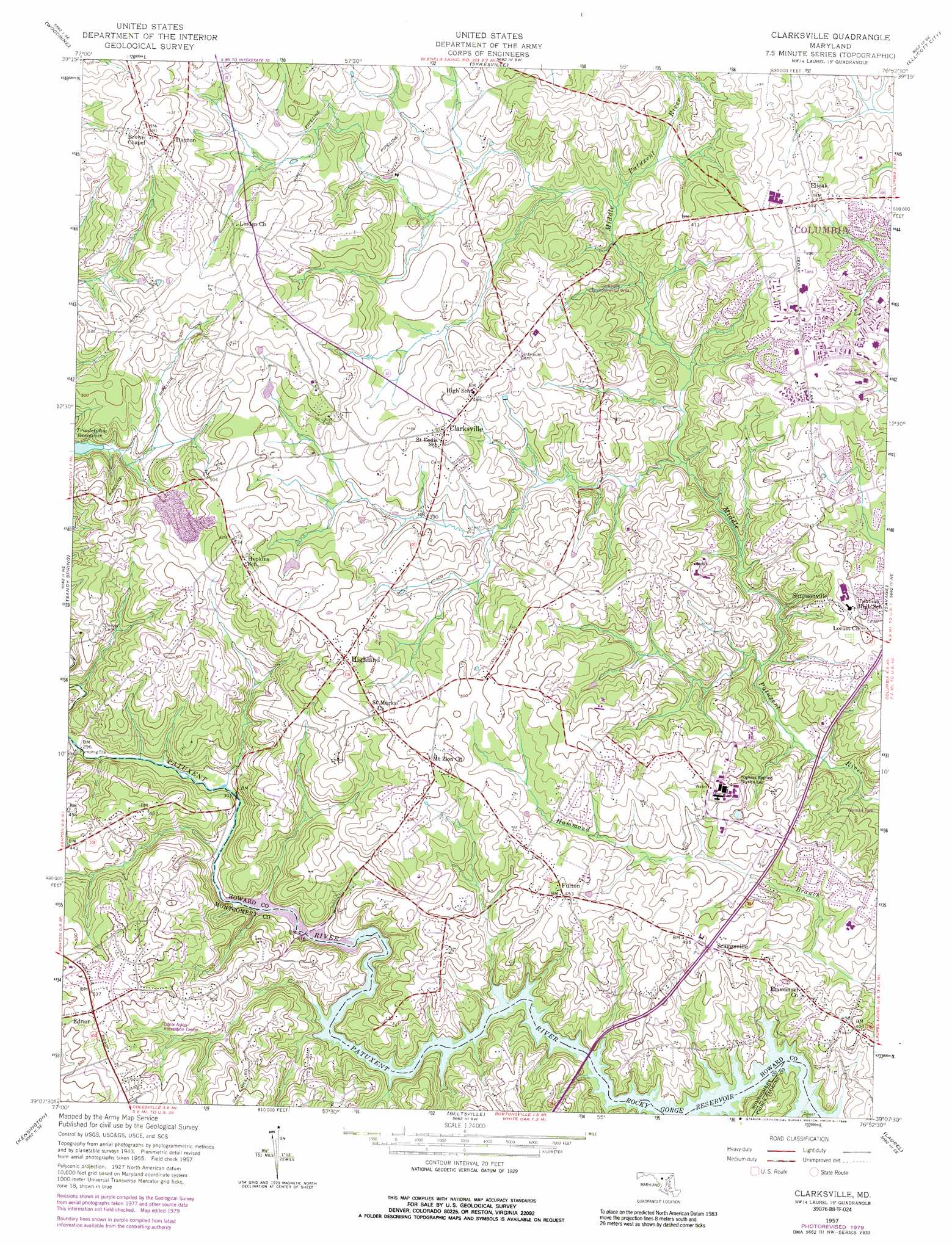
Clarksville Topo Map Maryland
To zoom in, hover over the map of Clarksville
USGS Topo Quad 39076b8 - 1:24,000 scale
| Topo Map Name: | Clarksville |
| USGS Topo Quad ID: | 39076b8 |
| Print Size: | ca. 21 1/4" wide x 27" high |
| Southeast Coordinates: | 39.125° N latitude / 76.875° W longitude |
| Map Center Coordinates: | 39.1875° N latitude / 76.9375° W longitude |
| U.S. State: | MD |
| Filename: | o39076b8.jpg |
| Download Map JPG Image: | Clarksville topo map 1:24,000 scale |
| Map Type: | Topographic |
| Topo Series: | 7.5´ |
| Map Scale: | 1:24,000 |
| Source of Map Images: | United States Geological Survey (USGS) |
| Alternate Map Versions: |
Clarksville MD 1951 Download PDF Buy paper map Clarksville MD 1951 Download PDF Buy paper map Clarksville MD 1957, updated 1960 Download PDF Buy paper map Clarksville MD 1957, updated 1966 Download PDF Buy paper map Clarksville MD 1957, updated 1972 Download PDF Buy paper map Clarksville MD 1957, updated 1979 Download PDF Buy paper map Clarksville MD 1957, updated 1989 Download PDF Buy paper map Clarksville MD 1957, updated 1989 Download PDF Buy paper map Clarksville MD 1981, updated 1986 Download PDF Buy paper map Clarksville MD 2011 Download PDF Buy paper map Clarksville MD 2014 Download PDF Buy paper map Clarksville MD 2016 Download PDF Buy paper map |
1:24,000 Topo Quads surrounding Clarksville
Libertytown |
Winfield |
Finksburg |
Reisterstown |
Cockeysville |
Damascus |
Woodbine |
Sykesville |
Ellicott City |
Baltimore West |
Gaithersburg |
Sandy Spring |
Clarksville |
Savage |
Relay |
Rockville |
Kensington |
Beltsville |
Laurel |
Odenton |
Falls Church |
Washington West |
Washington East |
Lanham |
Bowie |
> Back to 39076a1 at 1:100,000 scale
> Back to 39076a1 at 1:250,000 scale
> Back to U.S. Topo Maps home
Clarksville topo map: Gazetteer
Clarksville: Airports
Haysfield Airport elevation 115m 377′Howard County General Hospital Heliport elevation 143m 469′
Clarksville: Bridges
Browns Bridge elevation 82m 269′Snells Bridge elevation 100m 328′
Clarksville: Dams
Foreman Branch Dam elevation 164m 538′Johns Hopkins University Dam elevation 111m 364′
Clarksville: Parks
Cedar Lane Park elevation 147m 482′Clarksville Environmental Area elevation 117m 383′
Ednor Aston Recreation Center elevation 144m 472′
Hammond Park elevation 101m 331′
Hawthorn Park elevation 131m 429′
Middle Patuxent Environmental Area elevation 106m 347′
Schooley Mill Park elevation 146m 479′
Clarksville: Populated Places
Allnut Farms Estates elevation 159m 521′Ashmead elevation 130m 426′
Ashton Pond elevation 132m 433′
Beaufort Park elevation 138m 452′
Beech Creek elevation 136m 446′
Braeburn elevation 114m 374′
Briaridge elevation 135m 442′
Brighton Farm Estates elevation 139m 456′
Brighton Pines elevation 139m 456′
Broadwater Estates elevation 163m 534′
Cabin Hill elevation 167m 547′
Cedar Acres elevation 132m 433′
Cedar Knoll Farms elevation 154m 505′
Cedar Woods elevation 139m 456′
Chapel Woods elevation 146m 479′
Chelsea Estates elevation 123m 403′
Chris Mar Estates elevation 166m 544′
Chriswood Manor elevation 143m 469′
Clarksville elevation 147m 482′
Clarksville Meadows elevation 142m 465′
Clarksville Ridge elevation 128m 419′
Clarys Forest elevation 141m 462′
Clemens Crossing elevation 112m 367′
Cliftonbrook elevation 167m 547′
Coon Manor elevation 104m 341′
Dayton elevation 176m 577′
Dayton Meadows elevation 186m 610′
Dogwood elevation 141m 462′
Dunfretten Estates elevation 156m 511′
Ednor elevation 168m 551′
Ednor Acres elevation 170m 557′
Ednor Farms elevation 162m 531′
Ednor View elevation 147m 482′
Elioak elevation 130m 426′
Farside elevation 133m 436′
Faulkner Ridge elevation 125m 410′
Flamewood elevation 136m 446′
Forest Hills elevation 136m 446′
Fox Pause elevation 146m 479′
Foxhall Villas elevation 173m 567′
Fulton elevation 138m 452′
Gaither Farm Estates elevation 151m 495′
Graeloch Woods elevation 115m 377′
Green Hill Manor elevation 155m 508′
Greene Fields elevation 152m 498′
Greenwood Farms elevation 151m 495′
Hall Shop Estates elevation 148m 485′
Hallmark elevation 132m 433′
Hammond Hills elevation 114m 374′
Hammond Park elevation 127m 416′
Hammond Village elevation 122m 400′
Harpers Choice elevation 142m 465′
Haviland Hills elevation 160m 524′
Hawthorn elevation 125m 410′
Hawthorn North elevation 139m 456′
Hemlock Hill elevation 152m 498′
Heritage Heights elevation 150m 492′
Highland elevation 158m 518′
Highland Acres elevation 151m 495′
Highland Lake elevation 167m 547′
Hillcrest Heights elevation 114m 374′
Hobbits Glen elevation 128m 419′
Holiday Hills elevation 110m 360′
Holly House elevation 142m 465′
Hopkins Mead elevation 156m 511′
Jocelyn Acres elevation 167m 547′
Kindler Estates elevation 113m 370′
Kings Manor elevation 145m 475′
La Isla elevation 116m 380′
Leishear Knolls elevation 114m 374′
Leishear Village elevation 103m 337′
Lime Kiln Valley elevation 115m 377′
Linden Chapel Hills elevation 160m 524′
Linden Chapel Woods elevation 179m 587′
Longfellow elevation 119m 390′
Mauck Farm Estates elevation 135m 442′
Mill Grove Gardens elevation 161m 528′
Mooresfield elevation 142m 465′
Murray Hill elevation 109m 357′
Oak Hill Estates elevation 152m 498′
Patuxent Hills elevation 117m 383′
Pembroke Knolls elevation 111m 364′
Pine Valley elevation 108m 354′
Point of Homewood elevation 138m 452′
Raintree Estates elevation 149m 488′
Riverside elevation 98m 321′
Riverside Estates elevation 86m 282′
Rocky Gorge Meadows elevation 126m 413′
Saybrook elevation 114m 374′
Scaggsville elevation 137m 449′
Scott Acres elevation 148m 485′
Simpson Woods elevation 147m 482′
Simpsonville elevation 124m 406′
Swann Hills elevation 142m 465′
Swansfield elevation 141m 462′
The Chase elevation 128m 419′
Tower Acres elevation 123m 403′
Twelve Hills elevation 163m 534′
Twin Oaks elevation 116m 380′
Waterford elevation 168m 551′
White Oak Estates elevation 169m 554′
Williams Contrivance Estates elevation 123m 403′
Wood Ridge elevation 152m 498′
Clarksville: Post Offices
Clarksville Post Office elevation 154m 505′Dayton Post Office elevation 181m 593′
Fulton Post Office elevation 144m 472′
Highland Post Office elevation 159m 521′
Clarksville: Reservoirs
Johns Hopkins Pond elevation 111m 364′Clarksville: Streams
Carrolls Branch elevation 117m 383′Clarksville digital topo map on disk
Buy this Clarksville topo map showing relief, roads, GPS coordinates and other geographical features, as a high-resolution digital map file on DVD:
Atlantic Coast (NY, NJ, PA, DE, MD, VA, NC)
Buy digital topo maps: Atlantic Coast (NY, NJ, PA, DE, MD, VA, NC)
 map DVD")