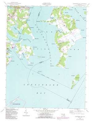
Gunpowder Neck Topo Map Maryland
To zoom in, hover over the map of Gunpowder Neck
USGS Topo Quad 39076c3 - 1:24,000 scale
| Topo Map Name: | Gunpowder Neck |
| USGS Topo Quad ID: | 39076c3 |
| Print Size: | ca. 21 1/4" wide x 27" high |
| Southeast Coordinates: | 39.25° N latitude / 76.25° W longitude |
| Map Center Coordinates: | 39.3125° N latitude / 76.3125° W longitude |
| U.S. State: | MD |
| Filename: | o39076c3.jpg |
| Download Map JPG Image: | Gunpowder Neck topo map 1:24,000 scale |
| Map Type: | Topographic |
| Topo Series: | 7.5´ |
| Map Scale: | 1:24,000 |
| Source of Map Images: | United States Geological Survey (USGS) |
| Alternate Map Versions: |
Gunpowder Neck MD 1949, updated 1969 Download PDF Buy paper map Gunpowder Neck MD 1949, updated 1971 Download PDF Buy paper map Gunpowder Neck MD 1949, updated 1979 Download PDF Buy paper map Gunpowder Neck MD 1949, updated 1987 Download PDF Buy paper map Gunpowder Neck MD 1949, updated 1987 Download PDF Buy paper map Gunpowder Neck MD 1951 Download PDF Buy paper map Gunpowder Neck MD 1951, updated 1951 Download PDF Buy paper map Gunpowder Neck MD 1995, updated 1999 Download PDF Buy paper map Gunpowder Neck MD 2011 Download PDF Buy paper map Gunpowder Neck MD 2014 Download PDF Buy paper map Gunpowder Neck MD 2016 Download PDF Buy paper map |
1:24,000 Topo Quads surrounding Gunpowder Neck
> Back to 39076a1 at 1:100,000 scale
> Back to 39076a1 at 1:250,000 scale
> Back to U.S. Topo Maps home
Gunpowder Neck topo map: Gazetteer
Gunpowder Neck: Bars
Spry Island Shoal elevation 0m 0′Gunpowder Neck: Bays
Cunninghill Cove elevation 0m 0′Doves Cove elevation 0m 0′
Hawthorn Cove elevation 0m 0′
Swaderick Creek elevation 1m 3′
Gunpowder Neck: Capes
Barren Point elevation 0m 0′Battery Point elevation 3m 9′
Bengies Point elevation 2m 6′
Brier Point elevation 2m 6′
Briery Point elevation 2m 6′
Carroll Point elevation 0m 0′
Days Point elevation 1m 3′
Ford Point elevation 2m 6′
Gunpowder Neck elevation 3m 9′
Lego Point elevation 0m 0′
Lower Island Point elevation 0m 0′
Marshy Point elevation 2m 6′
Maxwell Point elevation 2m 6′
Oliver Point elevation 0m 0′
Rickett Point elevation 0m 0′
Robins Point elevation 2m 6′
Sandy Point elevation 1m 3′
Sandy Point elevation 0m 0′
Weir Point elevation 2m 6′
White Oak Point elevation 3m 9′
Gunpowder Neck: Islands
Carroll Island elevation 3m 9′Hart-Miller Island elevation 0m 0′
Phillips Island (historical) elevation 0m 0′
Pooles Island elevation 3m 9′
Spry Island (historical) elevation 0m 0′
Gunpowder Neck: Parks
Dundee Natural Environment Area elevation 6m 19′Gunpowder State Park elevation 12m 39′
Hart-Miller Pleasure Islands Natural Resources Management Park elevation 4m 13′
Miami Beach Park elevation 3m 9′
Gunpowder Neck: Populated Places
Chase elevation 5m 16′Cunninghill Cove elevation 6m 19′
Harewood elevation 3m 9′
Miami Beach elevation 3m 9′
Oliver Beach elevation 3m 9′
Seneca Park elevation 4m 13′
Woods at Bay Country elevation 4m 13′
Gunpowder Neck: Post Offices
Chase Post Office elevation 6m 19′Gunpowder Neck: Streams
Boone Creek elevation 0m 0′Coopers Creek elevation 0m 0′
Dundee Creek elevation 0m 0′
Gunpowder River elevation 0m 0′
Saltpeter Creek elevation 0m 0′
Seneca Creek elevation 0m 0′
Watson Creek elevation 0m 0′
Wright Creek elevation 0m 0′
Gunpowder Neck: Swamps
Tripcellar Swamp elevation 3m 9′Gunpowder Neck digital topo map on disk
Buy this Gunpowder Neck topo map showing relief, roads, GPS coordinates and other geographical features, as a high-resolution digital map file on DVD:
Atlantic Coast (NY, NJ, PA, DE, MD, VA, NC)
Buy digital topo maps: Atlantic Coast (NY, NJ, PA, DE, MD, VA, NC)


