Sykesville Topo Map Maryland
To zoom in, hover over the map of Sykesville
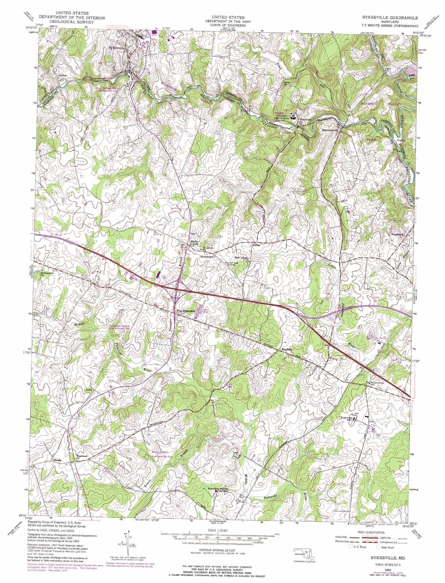
USGS Topo Quad 39076c8 - 1:24,000 scale
| Topo Map Name: | Sykesville |
| USGS Topo Quad ID: | 39076c8 |
| Print Size: | ca. 21 1/4" wide x 27" high |
| Southeast Coordinates: | 39.25° N latitude / 76.875° W longitude |
| Map Center Coordinates: | 39.3125° N latitude / 76.9375° W longitude |
| U.S. State: | MD |
| Filename: | o39076c8.jpg |
| Download Map JPG Image: | Sykesville topo map 1:24,000 scale |
| Map Type: | Topographic |
| Topo Series: | 7.5´ |
| Map Scale: | 1:24,000 |
| Source of Map Images: | United States Geological Survey (USGS) |
| Alternate Map Versions: |
Sykesville MD 1953, updated 1954 Download PDF Buy paper map Sykesville MD 1953, updated 1954 Download PDF Buy paper map Sykesville MD 1953, updated 1965 Download PDF Buy paper map Sykesville MD 1953, updated 1971 Download PDF Buy paper map Sykesville MD 1953, updated 1979 Download PDF Buy paper map Sykesville MD 1981, updated 1986 Download PDF Buy paper map Sykesville MD 2011 Download PDF Buy paper map Sykesville MD 2014 Download PDF Buy paper map Sykesville MD 2016 Download PDF Buy paper map |
1:24,000 Topo Quads surrounding Sykesville
Union Bridge |
New Windsor |
Westminister |
Hampstead |
Hereford |
Libertytown |
Winfield |
Finksburg |
Reisterstown |
Cockeysville |
Damascus |
Woodbine |
Sykesville |
Ellicott City |
Baltimore West |
Gaithersburg |
Sandy Spring |
Clarksville |
Savage |
Relay |
Rockville |
Kensington |
Beltsville |
Laurel |
Odenton |
> Back to 39076a1 at 1:100,000 scale
> Back to 39076a1 at 1:250,000 scale
> Back to U.S. Topo Maps home
Sykesville topo map: Gazetteer
Sykesville: Crossings
Interchange 80 elevation 160m 524′Interchange 82 elevation 152m 498′
Interchange 83 elevation 136m 446′
Sykesville: Parks
Alpha Ridge Community Park elevation 162m 531′Benson Branch Environmental Area elevation 146m 479′
Howard County Fairground elevation 165m 541′
Hugh Thomas Wildlife Management Area elevation 161m 528′
McKeldin Recreation Area elevation 114m 374′
Millard Cooper Park elevation 159m 521′
Peoples Gospel Park elevation 148m 485′
Pfefferkorn Natural Environmental Area elevation 169m 554′
Sykesville Historic District elevation 123m 403′
Sykesville: Populated Places
Albeth Heights elevation 139m 456′Alpha elevation 181m 593′
Amberly elevation 160m 524′
Annandale elevation 192m 629′
Benson elevation 162m 531′
Berndell Estates elevation 171m 561′
Bloomfield Manor elevation 181m 593′
Breezewood Farms elevation 133m 436′
Briar Hill elevation 138m 452′
Brosenne elevation 164m 538′
Buckskin Woods elevation 179m 587′
Burnt Woods elevation 190m 623′
Buttercup Estates elevation 159m 521′
Cameron Tract elevation 117m 383′
Carroll Fields elevation 164m 538′
Clarkson elevation 151m 495′
Crest Acres elevation 194m 636′
Donghoregan elevation 124m 406′
Driver elevation 155m 508′
Eagles Loft elevation 169m 554′
Eazee Acres elevation 167m 547′
Evergreen Valley Estates elevation 149m 488′
Everlea elevation 193m 633′
Fox Den Farms elevation 147m 482′
Friendship Manor elevation 167m 547′
Gaither elevation 127m 416′
Gaither Heights elevation 171m 561′
Gaither Manor elevation 179m 587′
Gerber Knoll elevation 170m 557′
Glenelg elevation 190m 623′
Gorsuch (historical) elevation 99m 324′
Green Henge elevation 145m 475′
Heatherwood elevation 183m 600′
Henryton elevation 93m 305′
Henryton Heights elevation 187m 613′
Heritage Farms elevation 174m 570′
Indian Hill elevation 184m 603′
Ivory elevation 175m 574′
Kingston elevation 187m 613′
Lexington Run elevation 161m 528′
Locust Ridge elevation 140m 459′
Marriottsville elevation 93m 305′
Mayfield elevation 171m 561′
Mountview elevation 198m 649′
Oakwood Overlook elevation 186m 610′
Patapsco Estates elevation 158m 518′
Prospect Hills elevation 163m 534′
Ridgeways elevation 193m 633′
River Park Estates elevation 167m 547′
Rose Mary Estates elevation 160m 524′
Rover (historical) elevation 143m 469′
Salopha elevation 152m 498′
Sand Hill Acres elevation 177m 580′
Sandy Hill elevation 162m 531′
Shannon Run elevation 155m 508′
Shepherds Glen elevation 187m 613′
Slacks Corner elevation 194m 636′
Sycamore Springs elevation 176m 577′
Sykesville elevation 166m 544′
The Corners elevation 192m 629′
Timberleigh elevation 126m 413′
Triadelphia Woods elevation 134m 439′
Turf Valley elevation 136m 446′
Valley Anne Estates elevation 130m 426′
Wayside Estates elevation 164m 538′
West Friendship elevation 149m 488′
Westcliffe Manor elevation 176m 577′
Woodmark elevation 137m 449′
Wynfield elevation 168m 551′
Sykesville: Post Offices
Gaither Post Office elevation 135m 442′Glenelg Post Office elevation 195m 639′
Henryton Post Office elevation 103m 337′
Marriottsville Post Office elevation 97m 318′
Sykesville Post Office elevation 147m 482′
West Friendship Post Office elevation 149m 488′
Woodstock Post Office elevation 129m 423′
Sykesville: Streams
Benson Branch elevation 106m 347′Falls Run elevation 90m 295′
North Branch Patapsco River elevation 76m 249′
Piney Branch elevation 127m 416′
Piney Run elevation 86m 282′
South Branch Patapsco River elevation 76m 249′
Terrapin Branch elevation 122m 400′
Sykesville digital topo map on disk
Buy this Sykesville topo map showing relief, roads, GPS coordinates and other geographical features, as a high-resolution digital map file on DVD:
Atlantic Coast (NY, NJ, PA, DE, MD, VA, NC)
Buy digital topo maps: Atlantic Coast (NY, NJ, PA, DE, MD, VA, NC)
 map DVD")