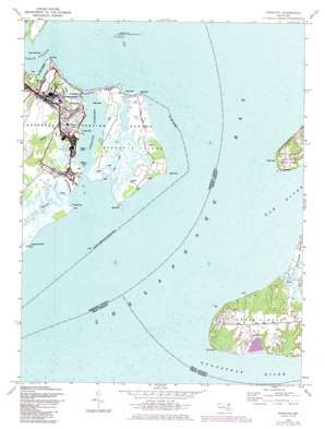
Spesutie Topo Map Maryland
To zoom in, hover over the map of Spesutie
USGS Topo Quad 39076d1 - 1:24,000 scale
| Topo Map Name: | Spesutie |
| USGS Topo Quad ID: | 39076d1 |
| Print Size: | ca. 21 1/4" wide x 27" high |
| Southeast Coordinates: | 39.375° N latitude / 76° W longitude |
| Map Center Coordinates: | 39.4375° N latitude / 76.0625° W longitude |
| U.S. State: | MD |
| Filename: | o39076d1.jpg |
| Download Map JPG Image: | Spesutie topo map 1:24,000 scale |
| Map Type: | Topographic |
| Topo Series: | 7.5´ |
| Map Scale: | 1:24,000 |
| Source of Map Images: | United States Geological Survey (USGS) |
| Alternate Map Versions: |
Spesutie MD 1948 Download PDF Buy paper map Spesutie MD 1948, updated 1972 Download PDF Buy paper map Spesutie MD 1948, updated 1976 Download PDF Buy paper map Spesutie MD 1948, updated 1985 Download PDF Buy paper map Spesutie MD 2011 Download PDF Buy paper map Spesutie MD 2014 Download PDF Buy paper map Spesutie MD 2016 Download PDF Buy paper map |
1:24,000 Topo Quads surrounding Spesutie
> Back to 39076a1 at 1:100,000 scale
> Back to 39076a1 at 1:250,000 scale
> Back to U.S. Topo Maps home
Spesutie topo map: Gazetteer
Spesutie: Bays
Sands Cove elevation 0m 0′Spesutie: Bridges
Spesutie Island Bridge elevation 0m 0′Spesutie: Capes
Bear Point elevation 0m 0′Black Point elevation 0m 0′
Brier Point elevation 0m 0′
Cedar Point elevation 0m 0′
Cherry Tree Point elevation 0m 0′
Grove Point elevation 5m 16′
Johnson Point elevation 2m 6′
Locust Point elevation 2m 6′
Mulberry Point elevation 0m 0′
Plum Point elevation 4m 13′
Sandy Point elevation 0m 0′
Swan Creek Point elevation 0m 0′
Turkey Point elevation 3m 9′
Woodpecker Point elevation 0m 0′
Spesutie: Channels
Spesutie Narrows elevation 0m 0′Spesutie: Dams
Grove Point Disposal Area Dam elevation 3m 9′Spesutie: Islands
Battery Island elevation 0m 0′Neds Island elevation 0m 0′
Spesutie Island elevation 2m 6′
Spesutie: Parks
Grove Point Wildlife Sanctuary elevation 3m 9′Susquehanna National Wildlife Refuge elevation 0m 0′
Spesutie: Populated Places
Chesapeake Haven elevation 14m 45′Cheshaven elevation 3m 9′
Hazelmoor elevation 6m 19′
Spesutie: Reservoirs
Grove Point Disposal Area Lake elevation 3m 9′Spesutie: Streams
Back Creek elevation 0m 0′Dipper Creek elevation 0m 0′
Elk River elevation 0m 0′
Little Mosquito Creek elevation 0m 0′
Mosquito Creek elevation 0m 0′
Pond Creek elevation 0m 0′
Sassafras River elevation 0m 0′
Swan Creek elevation 0m 0′
Woodrest Creek elevation 0m 0′
Spesutie digital topo map on disk
Buy this Spesutie topo map showing relief, roads, GPS coordinates and other geographical features, as a high-resolution digital map file on DVD:
Atlantic Coast (NY, NJ, PA, DE, MD, VA, NC)
Buy digital topo maps: Atlantic Coast (NY, NJ, PA, DE, MD, VA, NC)


