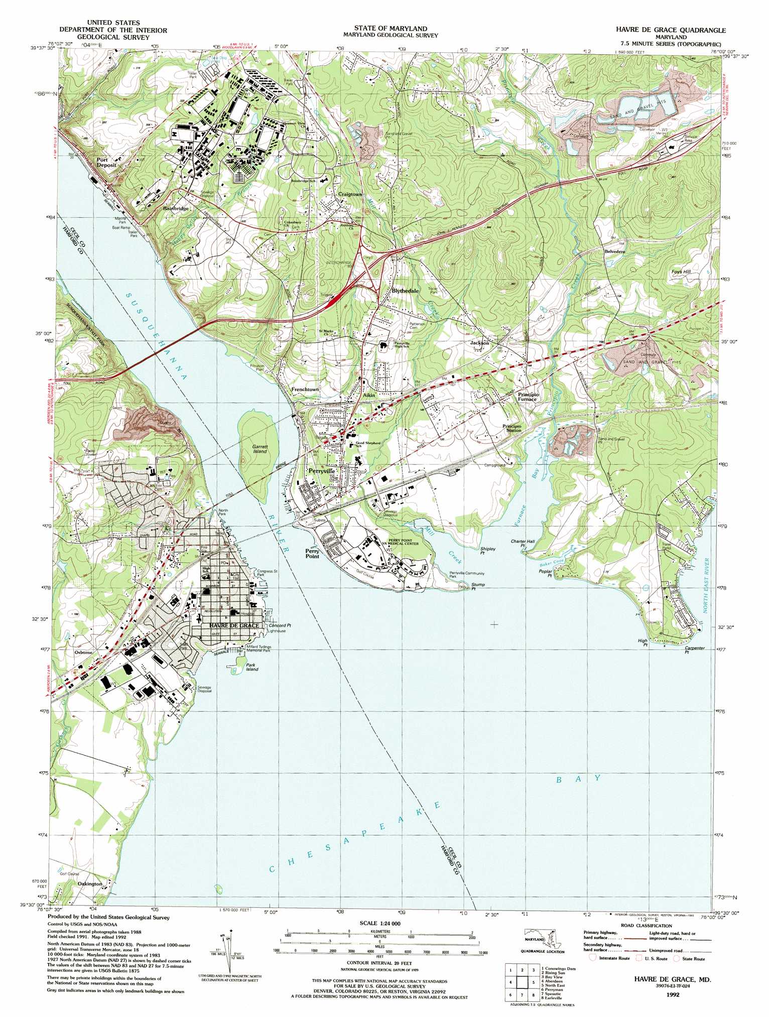
Havre De Grace Topo Map Maryland
To zoom in, hover over the map of Havre De Grace
USGS Topo Quad 39076e1 - 1:24,000 scale
| Topo Map Name: | Havre De Grace |
| USGS Topo Quad ID: | 39076e1 |
| Print Size: | ca. 21 1/4" wide x 27" high |
| Southeast Coordinates: | 39.5° N latitude / 76° W longitude |
| Map Center Coordinates: | 39.5625° N latitude / 76.0625° W longitude |
| U.S. State: | MD |
| Filename: | o39076e1.jpg |
| Download Map JPG Image: | Havre De Grace topo map 1:24,000 scale |
| Map Type: | Topographic |
| Topo Series: | 7.5´ |
| Map Scale: | 1:24,000 |
| Source of Map Images: | United States Geological Survey (USGS) |
| Alternate Map Versions: |
Havre De Grace MD 1953, updated 1955 Download PDF Buy paper map Havre De Grace MD 1953, updated 1955 Download PDF Buy paper map Havre De Grace MD 1953, updated 1965 Download PDF Buy paper map Havre De Grace MD 1953, updated 1971 Download PDF Buy paper map Havre De Grace MD 1953, updated 1977 Download PDF Buy paper map Havre De Grace MD 1953, updated 1984 Download PDF Buy paper map Havre De Grace MD 1953, updated 1985 Download PDF Buy paper map Havre De Grace MD 1953, updated 1991 Download PDF Buy paper map Havre De Grace MD 1992, updated 1993 Download PDF Buy paper map Havre De Grace MD 1998, updated 2000 Download PDF Buy paper map Havre De Grace MD 2011 Download PDF Buy paper map Havre De Grace MD 2014 Download PDF Buy paper map Havre De Grace MD 2016 Download PDF Buy paper map |
1:24,000 Topo Quads surrounding Havre De Grace
Holtwood |
Wakefield |
Kirkwood |
Oxford |
West Grove |
Delta |
Conowingo Dam |
Rising Sun |
Bay View |
Newark West |
Bel Air |
Aberdeen |
Havre De Grace |
North East |
Elkton |
Edgewood |
Perryman |
Spesutie |
Earleville |
Cecilton |
Gunpowder Neck |
Hanesville |
Betterton |
Galena |
Millington |
> Back to 39076e1 at 1:100,000 scale
> Back to 39076a1 at 1:250,000 scale
> Back to U.S. Topo Maps home
Havre De Grace topo map: Gazetteer
Havre De Grace: Airports
Gregory May Heliport elevation 13m 42′Havre de Grace Seaplane Base elevation 0m 0′
Havre De Grace: Bars
Pennys Shoal elevation 0m 0′Havre De Grace: Bays
Baker Cove elevation 8m 26′Furnace Bay elevation 0m 0′
Havre De Grace: Bridges
Millard E Tydings Memorial Bridge elevation 2m 6′Susquehanna Bridge elevation 5m 16′
Thomas Hatem Memorial Bridge elevation 8m 26′
Havre De Grace: Capes
Carpenter Point elevation 7m 22′Charter Hall Point elevation 11m 36′
Concord Point elevation 8m 26′
High Point elevation 14m 45′
Poplar Point elevation 17m 55′
Shipley Point elevation 8m 26′
Stump Point elevation 3m 9′
Havre De Grace: Crossings
Interchange 7 elevation 103m 337′Lower Susquehanna Ferry (historical) elevation 0m 0′
Havre De Grace: Dams
Mason Dixon Original Settling Pond Dam elevation 76m 249′Mason-Dixon Sand and Gravel Company of Pennsylvania Dam elevation 66m 216′
Mason-Dixon Settling Pond Number Five Dam elevation 105m 344′
Mason-Dixon Settling Pond Number Four Dam elevation 105m 344′
Mason-Dixon Settling Pond Number One Dam elevation 98m 321′
Mason-Dixon Settling Pond Number Six Dam elevation 112m 367′
Mason-Dixon Settling Pond Number Three Dam elevation 99m 324′
Mason-Dixon Settling Pond Number Two Dam elevation 99m 324′
Stancills Inc Settling Pond Dam elevation 10m 32′
Havre De Grace: Gaps
Susquehanna Point elevation 3m 9′Havre De Grace: Islands
Garrett Island elevation 24m 78′Park Island elevation 5m 16′
Saint Catherine Island elevation 1m 3′
Havre De Grace: Mines
Havre De Grace Quarry elevation -10m -33′McClenahan Granite Quarry elevation 10m 32′
Havre De Grace: Parks
Congress Street Park elevation 1m 3′Havre de Grace Historic District elevation 18m 59′
Holly Tree Park elevation 36m 118′
Jean Roberts Memorial Park elevation 1m 3′
Millard Tyding Memorial Park elevation 6m 19′
Millard Tydings Memorial Park elevation 4m 13′
North Park elevation 2m 6′
Perry Point Park elevation 6m 19′
Perryville Community Park elevation 8m 26′
Stancil Field Park elevation 16m 52′
Todd Park elevation 14m 45′
Tome School for Boys Historic District elevation 79m 259′
Whitaker Wildlife Management Area elevation 101m 331′
Havre De Grace: Populated Places
Aikin elevation 42m 137′Arrowhead Acres elevation 123m 403′
Bayview Estates elevation 69m 226′
Belvedere elevation 56m 183′
Blythedale elevation 92m 301′
Carpenter Point elevation 7m 22′
Chesapeake Landing elevation 47m 154′
Chestnut Point elevation 10m 32′
Chestnut Point Estates elevation 4m 13′
Concord elevation 19m 62′
Craigtown elevation 119m 390′
Foys Hill (historical) elevation 70m 229′
Frenchtown elevation 6m 19′
Grace Harbour elevation 101m 331′
Greenbank Farms elevation 13m 42′
Havre de Grace elevation 17m 55′
Havre de Grace Heights elevation 84m 275′
Highland Park elevation 126m 413′
Homestead Mobile Home Estates elevation 118m 387′
Jackson elevation 46m 150′
Manor Heights elevation 132m 433′
Meadowvale elevation 94m 308′
Meadowvale Manor elevation 64m 209′
Minnick elevation 16m 52′
Misty Meadows elevation 130m 426′
Mountain Hill elevation 31m 101′
Oakington elevation 19m 62′
Osborne elevation 24m 78′
Perry Point elevation 13m 42′
Perryville elevation 14m 45′
Poplar Point elevation 12m 39′
Port Deposit elevation 5m 16′
Principio Furnace elevation 21m 68′
Robin Acres elevation 139m 456′
Rock Run elevation 16m 52′
Running Brook Park elevation 116m 380′
Shawnee Brook South elevation 91m 298′
Sunnyside elevation 136m 446′
Havre De Grace: Post Offices
Havre de Grace Post Office elevation 15m 49′Perry Point Post Office elevation 12m 39′
Perryville Post Office elevation 14m 45′
Port Deposit Post Office elevation 4m 13′
Principio Furnace Post Office (historical) elevation 19m 62′
Havre De Grace: Reservoirs
Mason Dixon Original Settling Pond elevation 76m 249′Mason-Dixon Sand and Gravel Reservoir elevation 66m 216′
Perryville Reservoir elevation 52m 170′
Stancill Incorporated Reservoir elevation 10m 32′
Havre De Grace: Streams
Coudon Creek elevation 39m 127′Happy Valley Branch elevation 0m 0′
Herring Run elevation 1m 3′
Mill Creek elevation 0m 0′
North East River elevation 0m 0′
Principio Creek elevation 0m 0′
Susquehanna River elevation 0m 0′
Velvet Rock Branch elevation 0m 0′
Velvet Rock Branch elevation 1m 3′
Havre De Grace: Summits
Foys Hill elevation 96m 314′Mount Ararat elevation 129m 423′
Havre De Grace digital topo map on disk
Buy this Havre De Grace topo map showing relief, roads, GPS coordinates and other geographical features, as a high-resolution digital map file on DVD:
Atlantic Coast (NY, NJ, PA, DE, MD, VA, NC)
Buy digital topo maps: Atlantic Coast (NY, NJ, PA, DE, MD, VA, NC)
 map DVD")