Bel Air Topo Map Maryland
To zoom in, hover over the map of Bel Air
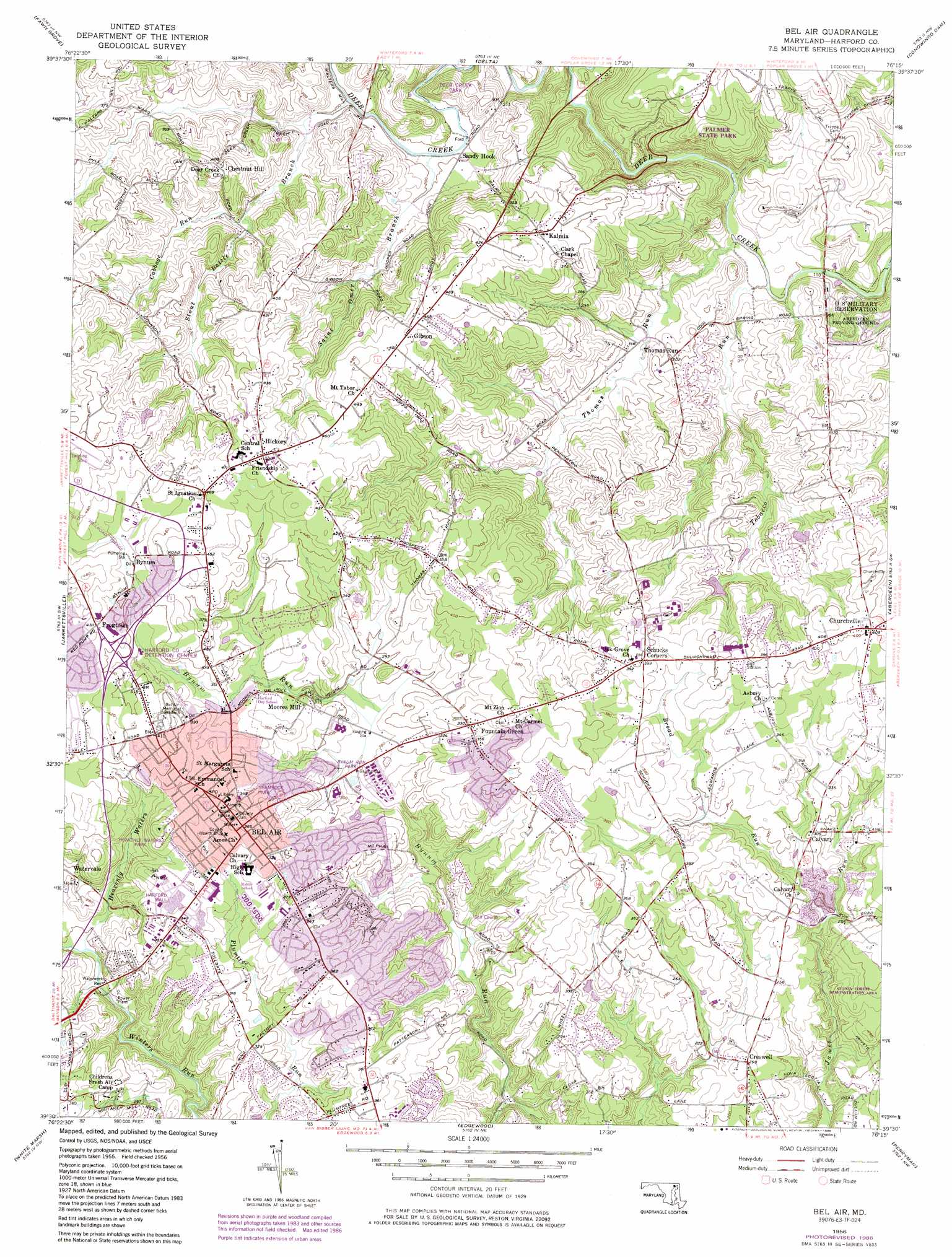
USGS Topo Quad 39076e3 - 1:24,000 scale
| Topo Map Name: | Bel Air |
| USGS Topo Quad ID: | 39076e3 |
| Print Size: | ca. 21 1/4" wide x 27" high |
| Southeast Coordinates: | 39.5° N latitude / 76.25° W longitude |
| Map Center Coordinates: | 39.5625° N latitude / 76.3125° W longitude |
| U.S. State: | MD |
| Filename: | o39076e3.jpg |
| Download Map JPG Image: | Bel Air topo map 1:24,000 scale |
| Map Type: | Topographic |
| Topo Series: | 7.5´ |
| Map Scale: | 1:24,000 |
| Source of Map Images: | United States Geological Survey (USGS) |
| Alternate Map Versions: |
Bel Air MD 1956, updated 1957 Download PDF Buy paper map Bel Air MD 1956, updated 1969 Download PDF Buy paper map Bel Air MD 1956, updated 1975 Download PDF Buy paper map Bel Air MD 1956, updated 1986 Download PDF Buy paper map Bel Air MD 2011 Download PDF Buy paper map Bel Air MD 2014 Download PDF Buy paper map Bel Air MD 2016 Download PDF Buy paper map |
1:24,000 Topo Quads surrounding Bel Air
Stewartstown |
Airville |
Holtwood |
Wakefield |
Kirkwood |
Norrisville |
Fawn Grove |
Delta |
Conowingo Dam |
Rising Sun |
Phoenix |
Jarrettsville |
Bel Air |
Aberdeen |
Havre De Grace |
Towson |
White Marsh |
Edgewood |
Perryman |
Spesutie |
Baltimore East |
Middle River |
Gunpowder Neck |
Hanesville |
Betterton |
> Back to 39076e1 at 1:100,000 scale
> Back to 39076a1 at 1:250,000 scale
> Back to U.S. Topo Maps home
Bel Air topo map: Gazetteer
Bel Air: Airports
Forest Hill Airport elevation 157m 515′Bel Air: Bridges
Priestford Bridge elevation 36m 118′Bel Air: Dams
Campus Hills Pond Dam elevation 127m 416′Priestford Hills Dam elevation 93m 305′
Bel Air: Forests
Stoney Forest Demonstration Area elevation 98m 321′Bel Air: Parks
Aquila Scott Park elevation 87m 285′Bel Air Courthouse Historic District elevation 118m 387′
Bel Air Park elevation 104m 341′
Bynum Run Park elevation 84m 275′
County Home Park elevation 88m 288′
Heavenly Waters Park elevation 111m 364′
Hickory Park elevation 135m 442′
Homestead Park elevation 103m 337′
Majors Choice Park elevation 109m 357′
Palmer State Park elevation 98m 321′
Plum Tree Park elevation 113m 370′
Shamrock Park elevation 115m 377′
Thomas Run Park elevation 121m 396′
Bel Air: Populated Places
Allendale Estates elevation 78m 255′Allibone (historical) elevation 64m 209′
Amyclae Estates elevation 104m 341′
Bel Air elevation 126m 413′
Bel Air Acres elevation 83m 272′
Big Woods elevation 135m 442′
Bradford Village elevation 93m 305′
Bramblewood elevation 102m 334′
Brentwood Park elevation 142m 465′
Brierwood elevation 90m 295′
Bright Oaks elevation 94m 308′
Bynum elevation 136m 446′
Calvary elevation 95m 311′
Camelot elevation 97m 318′
Campus Hill Farms elevation 104m 341′
Campus Hills Estates elevation 112m 367′
Campus Valley Estates elevation 113m 370′
Cedar Spring elevation 86m 282′
Chatham elevation 94m 308′
Chestnut Hill elevation 132m 433′
Coffman elevation 144m 472′
Colonial Acres elevation 106m 347′
Cool Spring elevation 60m 196′
Corns Manor elevation 131m 429′
Country Club Park elevation 100m 328′
Country Village elevation 117m 383′
Creswell elevation 80m 262′
Deercreek (historical) elevation 90m 295′
Deerhaven elevation 127m 416′
Drexel elevation 136m 446′
Eagle Estates elevation 106m 347′
English Country Manor elevation 102m 334′
Evergreen Heights elevation 100m 328′
Fairmont elevation 110m 360′
Fairway elevation 96m 314′
Fairwind Farms elevation 102m 334′
Fairwood Heights elevation 138m 452′
Forest Lawn elevation 120m 393′
Fountain Glen elevation 115m 377′
Fountain Green elevation 112m 367′
Fountain Green Estates elevation 144m 472′
Fountain Green Heights elevation 104m 341′
Fountain Green Mobile Home Park elevation 114m 374′
Fox Bow elevation 97m 318′
Foxborough Farms elevation 108m 354′
Friendship Heights elevation 122m 400′
Frogtown elevation 136m 446′
Gibson elevation 156m 511′
Gibson Manor elevation 143m 469′
Glenangus elevation 104m 341′
Glengate elevation 109m 357′
Glenwood elevation 92m 301′
Glenwood Garth elevation 86m 282′
Grafton Heights elevation 116m 380′
Green Ridge elevation 131m 429′
Greenbrier Hills elevation 91m 298′
Grose Close elevation 94m 308′
Hampton Ridge elevation 110m 360′
Harford Dale elevation 124m 406′
Harford Hills elevation 120m 393′
Harford Ranchettes elevation 106m 347′
Harford Village elevation 141m 462′
Harford Woods elevation 102m 334′
Harlan Square elevation 114m 374′
Harold Heights elevation 96m 314′
Hemlock Ridge elevation 93m 305′
Heritage Woods elevation 111m 364′
Hickory elevation 157m 515′
Hickory Hills elevation 112m 367′
Hickory Hills elevation 148m 485′
Hickory Village Mobile Home Park elevation 146m 479′
Hill-N-Dale elevation 138m 452′
Hillview elevation 127m 416′
Homestead Village elevation 110m 360′
Howard Park elevation 120m 393′
Joppa Hills elevation 105m 344′
Kalmia elevation 135m 442′
Kings Charter elevation 92m 301′
Knollwood elevation 145m 475′
Leew Woods elevation 120m 393′
Lindill Estates elevation 106m 347′
Locust Knoll elevation 94m 308′
Longmeadow elevation 115m 377′
Lyns Rest elevation 108m 354′
Magness elevation 85m 278′
Majors Choice elevation 118m 387′
Martindale elevation 157m 515′
Maryland Ponderosa elevation 103m 337′
Marywood elevation 137m 449′
Meadow Springs elevation 126m 413′
Mechanicsville (historical) elevation 139m 456′
Melrose elevation 140m 459′
Michaels Corner elevation 115m 377′
Michaels Meadows elevation 155m 508′
Moores Mill elevation 114m 374′
Moorland elevation 115m 377′
Morgan Park elevation 121m 396′
Moxley Acres elevation 123m 403′
North Bel Air elevation 124m 406′
Northridge elevation 62m 203′
Oak Dale elevation 128m 419′
Oak Ridge elevation 105m 344′
Old Dixie Manor elevation 146m 479′
Old Fields elevation 111m 364′
Parsons Ridge elevation 82m 269′
Pegasus Estates elevation 101m 331′
Pheasant Ridge elevation 135m 442′
Pine Crest elevation 133m 436′
Priestford Hills elevation 97m 318′
Prospect Heights elevation 130m 426′
Roland Heights elevation 130m 426′
Roland Place elevation 126m 413′
Sable Woods elevation 109m 357′
Scots Fancy elevation 91m 298′
Shamrock elevation 118m 387′
Shucks Corners elevation 123m 403′
Silver Spring Heights elevation 114m 374′
South Bel Air elevation 116m 380′
Southampton elevation 94m 308′
Stonehedge elevation 125m 410′
Stoneleigh elevation 130m 426′
Thomas Run elevation 63m 206′
Todd Estates elevation 43m 141′
Todd Lakes elevation 92m 301′
Tollgate Estates elevation 96m 314′
Tudor Forest elevation 122m 400′
Tudor Manor elevation 122m 400′
Upper Crest Estates elevation 108m 354′
Village of Thomas Run elevation 120m 393′
Voshelle elevation 156m 511′
Wakefield Manor elevation 104m 341′
Wakefield Meadows elevation 114m 374′
Wakely Terrace elevation 109m 357′
Warwick elevation 104m 341′
Watervale elevation 91m 298′
Wellington Woods elevation 117m 383′
West Riding elevation 93m 305′
White Oak elevation 97m 318′
Woodside elevation 125m 410′
Worthington Heights elevation 69m 226′
Bel Air: Post Offices
Bel Air Post Office elevation 122m 400′Churchville Post Office elevation 129m 423′
Bel Air: Reservoirs
Campus Hills Pond elevation 127m 416′Michaels Mill Dam elevation 93m 305′
Bel Air: Streams
Broad Run elevation 71m 232′Cabbage Run elevation 91m 298′
Farnandis Branch elevation 69m 226′
Heavenly Waters elevation 59m 193′
Saint Omer Branch elevation 61m 200′
Stout Bottle Branch elevation 59m 193′
Thomas Run elevation 40m 131′
Tobacco Run elevation 33m 108′
Bel Air digital topo map on disk
Buy this Bel Air topo map showing relief, roads, GPS coordinates and other geographical features, as a high-resolution digital map file on DVD:
Atlantic Coast (NY, NJ, PA, DE, MD, VA, NC)
Buy digital topo maps: Atlantic Coast (NY, NJ, PA, DE, MD, VA, NC)
 map DVD")