Manchester Topo Map Maryland
To zoom in, hover over the map of Manchester
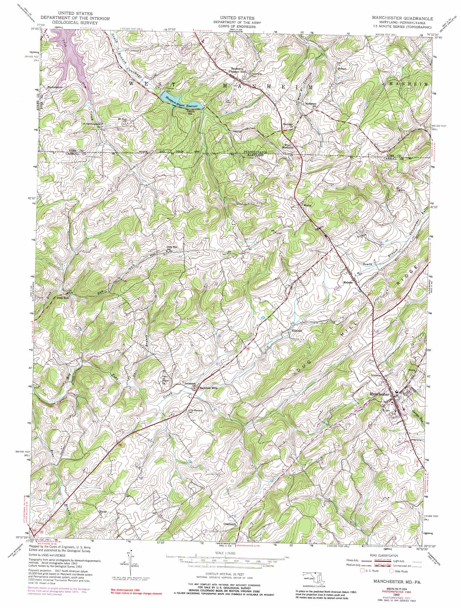
USGS Topo Quad 39076f8 - 1:24,000 scale
| Topo Map Name: | Manchester |
| USGS Topo Quad ID: | 39076f8 |
| Print Size: | ca. 21 1/4" wide x 27" high |
| Southeast Coordinates: | 39.625° N latitude / 76.875° W longitude |
| Map Center Coordinates: | 39.6875° N latitude / 76.9375° W longitude |
| U.S. States: | MD, PA |
| Filename: | o39076f8.jpg |
| Download Map JPG Image: | Manchester topo map 1:24,000 scale |
| Map Type: | Topographic |
| Topo Series: | 7.5´ |
| Map Scale: | 1:24,000 |
| Source of Map Images: | United States Geological Survey (USGS) |
| Alternate Map Versions: |
Manchester MD 1953, updated 1954 Download PDF Buy paper map Manchester MD 1953, updated 1954 Download PDF Buy paper map Manchester MD 1953, updated 1966 Download PDF Buy paper map Manchester MD 1953, updated 1972 Download PDF Buy paper map Manchester MD 1953, updated 1976 Download PDF Buy paper map Manchester MD 1953, updated 1988 Download PDF Buy paper map Manchester MD 2011 Download PDF Buy paper map Manchester MD 2014 Download PDF Buy paper map Manchester MD 2016 Download PDF Buy paper map |
1:24,000 Topo Quads surrounding Manchester
Biglerville |
Hampton |
Abbottstown |
West York |
York |
Gettysburg |
Mcsherrystown |
Hanover |
Seven Valleys |
Glen Rock |
Taneytown |
Littlestown |
Manchester |
Lineboro |
New Freedom |
Union Bridge |
New Windsor |
Westminister |
Hampstead |
Hereford |
Libertytown |
Winfield |
Finksburg |
Reisterstown |
Cockeysville |
> Back to 39076e1 at 1:100,000 scale
> Back to 39076a1 at 1:250,000 scale
> Back to U.S. Topo Maps home
Manchester topo map: Gazetteer
Manchester: Dams
Hanover Dam elevation 214m 702′Sheppard-Meyers Dam elevation 214m 702′
Manchester: Parks
Christmas Tree Park elevation 313m 1026′Hanover Watershed Wildlife Management Area elevation 270m 885′
Hashawha Environmental Center elevation 198m 649′
Pine Valley Park elevation 267m 875′
Westside Memorial Park elevation 269m 882′
Manchester: Populated Places
Advocates Choice elevation 214m 702′Allana Acres elevation 319m 1046′
Bachman Mills elevation 202m 662′
Bachman Valley Estates elevation 202m 662′
Bandanna elevation 271m 889′
Bixler elevation 231m 757′
Bixler Valley Estates elevation 252m 826′
Brook Hill Acres elevation 267m 875′
Cape Hill Farms elevation 286m 938′
Country Life Estates elevation 294m 964′
Country Trails elevation 282m 925′
Cranberry elevation 265m 869′
Dayspring Estates elevation 279m 915′
Deep Run elevation 196m 643′
Dug Hill elevation 259m 849′
Ebbvale elevation 219m 718′
Ebbvale Estates elevation 291m 954′
Fridinger Estates elevation 210m 688′
Glasers Hill elevation 290m 951′
Grand Valley Acres elevation 263m 862′
Hideaway Estates elevation 248m 813′
Hobart elevation 246m 807′
Holland Hills elevation 283m 928′
Manchester elevation 302m 990′
Meadow View elevation 271m 889′
Melrose elevation 244m 800′
Mich-Trace Estates elevation 242m 793′
Oakleigh Ridge elevation 307m 1007′
Park Ridge elevation 310m 1017′
Pineridge Farms elevation 262m 859′
Pleasant Acres elevation 279m 915′
Rarjem Acres elevation 302m 990′
Raubenstine elevation 205m 672′
Reeds Village elevation 312m 1023′
Ross Run Estates elevation 222m 728′
Royal Heights elevation 320m 1049′
Spring Meadow elevation 218m 715′
Sterner Heights Estates elevation 266m 872′
Taylors Choice elevation 286m 938′
Valley View elevation 332m 1089′
Valley Vista North elevation 266m 872′
Wentz elevation 302m 990′
West Hill elevation 295m 967′
West Manheim elevation 294m 964′
Westchester Square elevation 293m 961′
Whispering Valley elevation 282m 925′
Manchester: Post Offices
Manchester Post Office elevation 302m 990′Manchester: Reservoirs
Lake Hashawha elevation 187m 613′Sheppard-Meyers Reservoir elevation 214m 702′
Manchester: Springs
Manchester Spring elevation 300m 984′Martin Spring elevation 195m 639′
Manchester: Streams
Ohio Branch elevation 185m 606′Manchester digital topo map on disk
Buy this Manchester topo map showing relief, roads, GPS coordinates and other geographical features, as a high-resolution digital map file on DVD:
Atlantic Coast (NY, NJ, PA, DE, MD, VA, NC)
Buy digital topo maps: Atlantic Coast (NY, NJ, PA, DE, MD, VA, NC)
 map DVD")