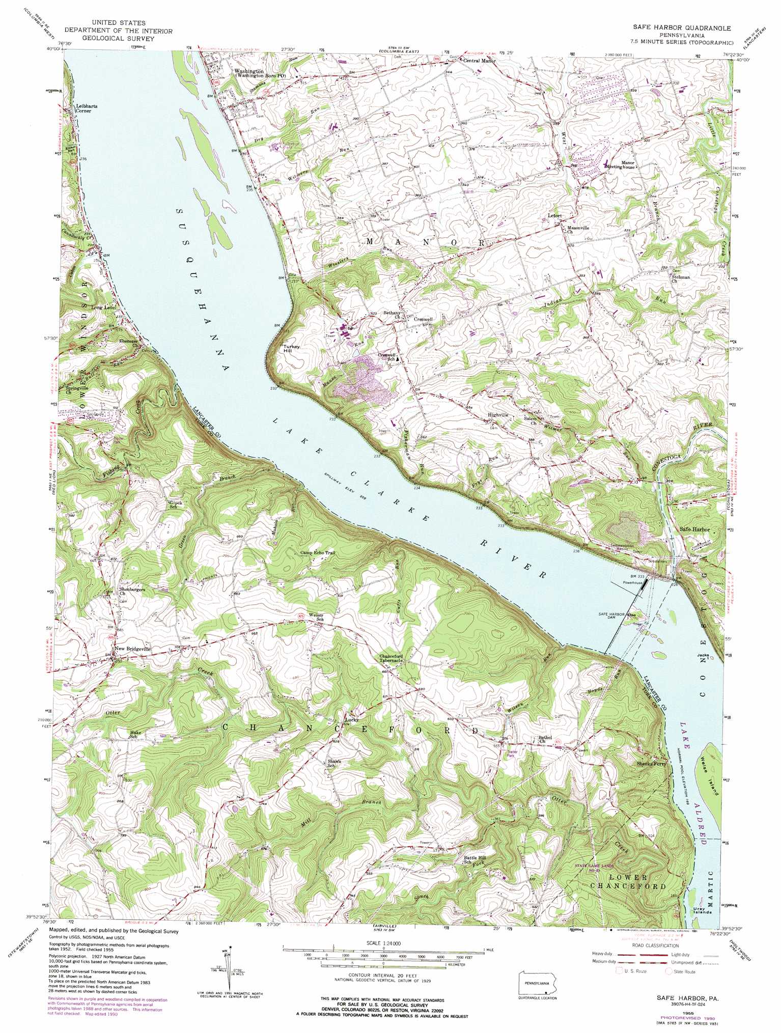
Safe Harbor Topo Map Pennsylvania
To zoom in, hover over the map of Safe Harbor
USGS Topo Quad 39076h4 - 1:24,000 scale
| Topo Map Name: | Safe Harbor |
| USGS Topo Quad ID: | 39076h4 |
| Print Size: | ca. 21 1/4" wide x 27" high |
| Southeast Coordinates: | 39.875° N latitude / 76.375° W longitude |
| Map Center Coordinates: | 39.9375° N latitude / 76.4375° W longitude |
| U.S. State: | PA |
| Filename: | o39076h4.jpg |
| Download Map JPG Image: | Safe Harbor topo map 1:24,000 scale |
| Map Type: | Topographic |
| Topo Series: | 7.5´ |
| Map Scale: | 1:24,000 |
| Source of Map Images: | United States Geological Survey (USGS) |
| Alternate Map Versions: |
Safe Harbor PA 1955, updated 1956 Download PDF Buy paper map Safe Harbor PA 1955, updated 1965 Download PDF Buy paper map Safe Harbor PA 1955, updated 1971 Download PDF Buy paper map Safe Harbor PA 1955, updated 1976 Download PDF Buy paper map Safe Harbor PA 1955, updated 1977 Download PDF Buy paper map Safe Harbor PA 1955, updated 1989 Download PDF Buy paper map Safe Harbor PA 1955, updated 1991 Download PDF Buy paper map Safe Harbor PA 1995, updated 1996 Download PDF Buy paper map Safe Harbor PA 2010 Download PDF Buy paper map Safe Harbor PA 2013 Download PDF Buy paper map Safe Harbor PA 2016 Download PDF Buy paper map |
1:24,000 Topo Quads surrounding Safe Harbor
Middletown |
Elizabethtown |
Manheim |
Lititz |
Ephrata |
York Haven |
Columbia West |
Columbia East |
Lancaster |
Leola |
York |
Red Lion |
Safe Harbor |
Conestoga |
Quarryville |
Glen Rock |
Stewartstown |
Airville |
Holtwood |
Wakefield |
New Freedom |
Norrisville |
Fawn Grove |
Delta |
Conowingo Dam |
> Back to 39076e1 at 1:100,000 scale
> Back to 39076a1 at 1:250,000 scale
> Back to U.S. Topo Maps home
Safe Harbor topo map: Gazetteer
Safe Harbor: Dams
Safe Harbor Dam elevation 56m 183′Safe Harbor: Islands
Else Island elevation 55m 180′Indian Rock Island elevation 55m 180′
Weise Island elevation 55m 180′
Safe Harbor: Populated Places
Bridgeville elevation 76m 249′Central Manor elevation 109m 357′
Creswell elevation 165m 541′
Highville elevation 180m 590′
Leibharts Corner elevation 71m 232′
Letort elevation 110m 360′
Lockport elevation 98m 321′
Lucky elevation 159m 521′
New Bridgeville elevation 211m 692′
Safe Harbor elevation 86m 282′
Shenks Ferry elevation 60m 196′
Star Rock elevation 78m 255′
Washington Boro elevation 87m 285′
Youngstown elevation 115m 377′
Safe Harbor: Post Offices
Highville Post Office (historical) elevation 180m 590′Safe Harbor Post Office (historical) elevation 86m 282′
Washington Manor Post Office (historical) elevation 87m 285′
Safe Harbor: Reservoirs
Lake Clarke elevation 56m 183′Safe Harbor: Streams
Boyds Run elevation 49m 160′Bull Run elevation 67m 219′
Cabin Creek elevation 67m 219′
Canadochly Creek elevation 67m 219′
Conestoga River elevation 52m 170′
Cuffs Run elevation 72m 236′
Dry Run elevation 71m 232′
Fisherman Run elevation 73m 239′
Fishing Creek elevation 67m 219′
Frys Run elevation 72m 236′
Green Branch elevation 67m 219′
Klines Run elevation 67m 219′
Klines Run elevation 67m 219′
Mahala Run elevation 67m 219′
Manns Run elevation 72m 236′
Mill Branch elevation 124m 406′
Otter Creek elevation 49m 160′
Shumans Run elevation 71m 232′
South Fork Otter Creek elevation 109m 357′
Stamans Run elevation 70m 229′
West Branch Little Conestoga Creek elevation 67m 219′
Wilson Run elevation 67m 219′
Wisslers Run elevation 73m 239′
Witmer Run elevation 53m 173′
Witmers Run elevation 71m 232′
Safe Harbor: Summits
Turkey Hill elevation 184m 603′Safe Harbor: Trails
Camp Echo Trail elevation 195m 639′Safe Harbor: Valleys
Conejohela Valley elevation 67m 219′Safe Harbor digital topo map on disk
Buy this Safe Harbor topo map showing relief, roads, GPS coordinates and other geographical features, as a high-resolution digital map file on DVD:
Atlantic Coast (NY, NJ, PA, DE, MD, VA, NC)
Buy digital topo maps: Atlantic Coast (NY, NJ, PA, DE, MD, VA, NC)
 map DVD")