Kensington Topo Map Maryland
To zoom in, hover over the map of Kensington
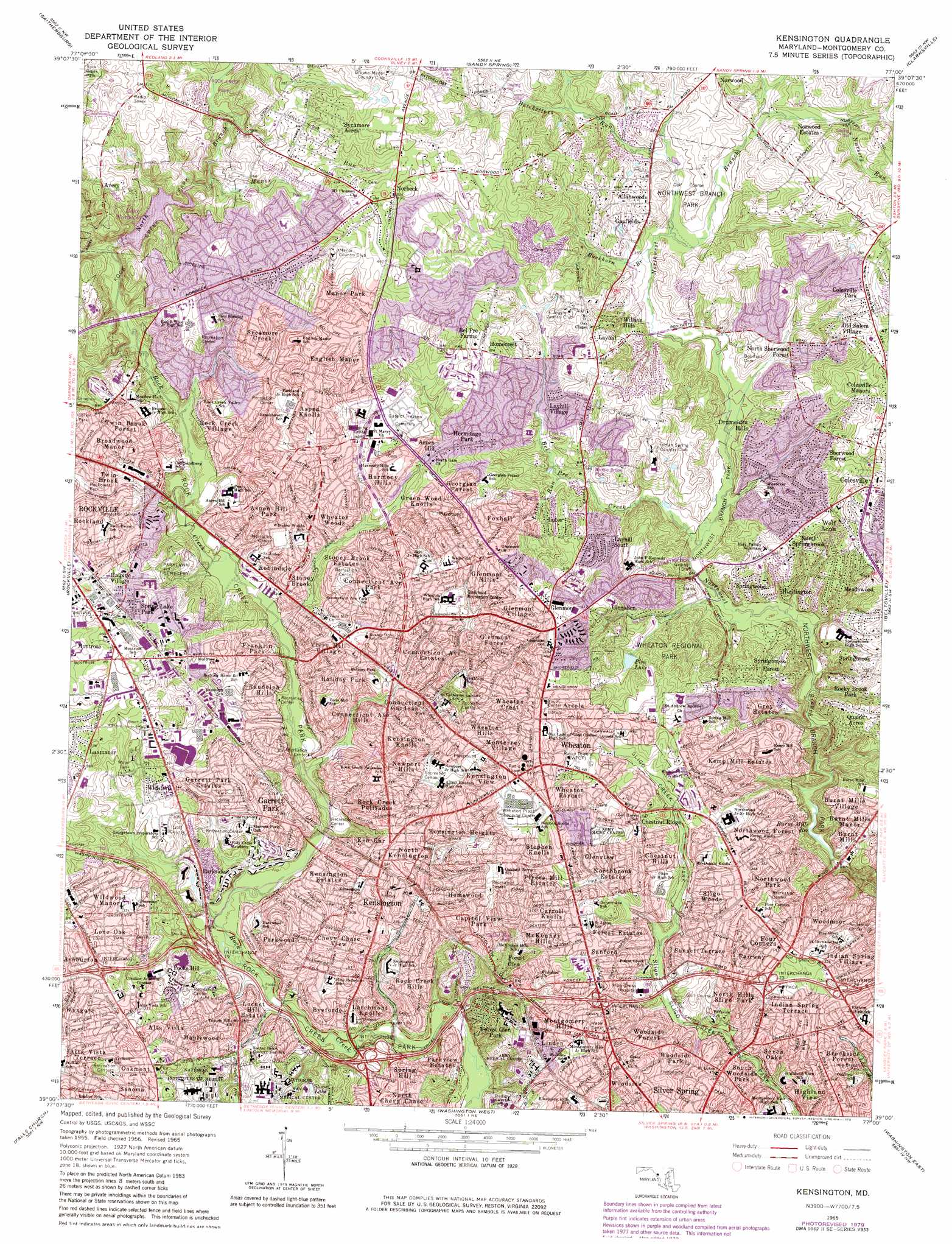
USGS Topo Quad 39077a1 - 1:24,000 scale
| Topo Map Name: | Kensington |
| USGS Topo Quad ID: | 39077a1 |
| Print Size: | ca. 21 1/4" wide x 27" high |
| Southeast Coordinates: | 39° N latitude / 77° W longitude |
| Map Center Coordinates: | 39.0625° N latitude / 77.0625° W longitude |
| U.S. State: | MD |
| Filename: | o39077a1.jpg |
| Download Map JPG Image: | Kensington topo map 1:24,000 scale |
| Map Type: | Topographic |
| Topo Series: | 7.5´ |
| Map Scale: | 1:24,000 |
| Source of Map Images: | United States Geological Survey (USGS) |
| Alternate Map Versions: |
Kensington MD 1951 Download PDF Buy paper map Kensington MD 1951 Download PDF Buy paper map Kensington MD 1956, updated 1958 Download PDF Buy paper map Kensington MD 1956, updated 1963 Download PDF Buy paper map Kensington MD 1965, updated 1966 Download PDF Buy paper map Kensington MD 1965, updated 1972 Download PDF Buy paper map Kensington MD 1965, updated 1979 Download PDF Buy paper map Kensington MD 1965, updated 1979 Download PDF Buy paper map Kensington MD 2011 Download PDF Buy paper map Kensington MD 2014 Download PDF Buy paper map Kensington MD 2016 Download PDF Buy paper map |
1:24,000 Topo Quads surrounding Kensington
Urbana |
Damascus |
Woodbine |
Sykesville |
Ellicott City |
Germantown |
Gaithersburg |
Sandy Spring |
Clarksville |
Savage |
Seneca |
Rockville |
Kensington |
Beltsville |
Laurel |
Vienna |
Falls Church |
Washington West |
Washington East |
Lanham |
Fairfax |
Annandale |
Alexandria |
Anacostia |
Upper Marlboro |
> Back to 39077a1 at 1:100,000 scale
> Back to 39076a1 at 1:250,000 scale
> Back to U.S. Topo Maps home
Kensington topo map: Gazetteer
Kensington: Airports
Walter Reed Forest Glen Heliport elevation 100m 328′Kensington: Crossings
Interchange 29 elevation 97m 318′Interchange 30 elevation 97m 318′
Interchange 31 elevation 102m 334′
Interchange 33 elevation 69m 226′
Interchange 34 elevation 68m 223′
Interchange 35 elevation 77m 252′
Interchange 36 elevation 98m 321′
Kensington: Dams
Upper Rock Creek Watershed Site Number 1 Dam elevation 83m 272′Wheaton Regional Park Dam elevation 115m 377′
Kensington: Parks
Aquarius Park elevation 132m 433′Arctic Park elevation 94m 308′
Argyle Park elevation 105m 344′
Ayrlawn Park elevation 96m 314′
Bel Pre Park elevation 105m 344′
Breewood Park elevation 106m 347′
Brookside Botanical Gardens elevation 102m 334′
Calvin Park elevation 108m 354′
Capital View Park elevation 92m 301′
Connecticut Avenue Park elevation 95m 311′
Earle B Wood Park elevation 110m 360′
Fairview Park elevation 95m 311′
Fleming Park elevation 89m 291′
Flower Valley Park elevation 113m 370′
Georgian Forest Park elevation 117m 383′
Glenfield Park elevation 124m 406′
Homewood-Capital View Park elevation 126m 413′
Kemp Mill Park elevation 120m 393′
Kensington Heights Park elevation 99m 324′
Layhill Park elevation 98m 321′
Layhill Village Park elevation 124m 406′
Meadowood Park elevation 107m 351′
Middle Brook Park elevation 103m 337′
Montgomery Hills Park elevation 113m 370′
Newport Mill Park elevation 113m 370′
North Gate Park elevation 117m 383′
Norwood Park elevation 104m 341′
Pleasant View Park elevation 123m 403′
Rock Creek Stream Valley Park elevation 102m 334′
Rockcrest Park elevation 101m 331′
Saddlebrook Park elevation 112m 367′
Saint Paul Park elevation 88m 288′
Sherwood Forest Park elevation 94m 308′
Sligo Creek Park elevation 79m 259′
Stonegate Park elevation 131m 429′
Strathmore Park elevation 114m 374′
Twinbrook Park elevation 102m 334′
Valleywood Park elevation 110m 360′
Wall Park elevation 118m 387′
Waverly Park elevation 87m 285′
Wheaton Regional Park elevation 122m 400′
Wheaton Woods Park elevation 105m 344′
YMCA Silver Spring Community Branch Park elevation 124m 406′
Kensington: Populated Places
Allanwood elevation 108m 354′Alta Vista elevation 92m 301′
Alta Vista Terrace elevation 96m 314′
Arcola elevation 137m 449′
Aspen Hill elevation 100m 328′
Aspen Hill Park elevation 105m 344′
Aspen Knolls elevation 124m 406′
Avery elevation 137m 449′
Bel Pre Farms elevation 134m 439′
Bonifant Village elevation 114m 374′
Broadwood Manor elevation 115m 377′
Brookside Forest elevation 94m 308′
Burnt Mills elevation 92m 301′
Burnt Mills Manor elevation 88m 288′
Burnt Mills Village elevation 102m 334′
Byeforde elevation 83m 272′
Capitol View Park elevation 119m 390′
Carroll Knolls elevation 109m 357′
Chestnut Hills elevation 113m 370′
Chestnut Ridge elevation 118m 387′
Chevy Chase View elevation 96m 314′
Colesville elevation 133m 436′
Colesville Manor elevation 131m 429′
Colesville Park elevation 144m 472′
College View elevation 125m 410′
Connecticut Avenue Estates elevation 98m 321′
Connecticut Avenue Hills elevation 97m 318′
Connecticut Avenue Park elevation 109m 357′
Connecticut Gardens elevation 103m 337′
Drumeldra Hills elevation 104m 341′
English Manor elevation 120m 393′
Fairway elevation 103m 337′
Forest Estates elevation 110m 360′
Forest Glen elevation 96m 314′
Forest Glen Park elevation 95m 311′
Forest Grove (historical) elevation 109m 357′
Four Corners elevation 103m 337′
Foxhall elevation 121m 396′
Franklin Park elevation 90m 295′
Garrett Park elevation 87m 285′
Garrett Park Estates elevation 88m 288′
Gayfields elevation 107m 351′
Georgian Colonies elevation 137m 449′
Georgian Forest elevation 118m 387′
Glemont Forest elevation 127m 416′
Glen Haven elevation 112m 367′
Glenallen elevation 113m 370′
Glenmont elevation 135m 442′
Glenmont Hills elevation 131m 429′
Glenmont Village elevation 131m 429′
Glenview elevation 108m 354′
Green Wood Knolls elevation 107m 351′
Grey Estates elevation 100m 328′
Halpine Village elevation 109m 357′
Harmony Hills elevation 102m 334′
Hermitage Park elevation 119m 390′
Highland View elevation 100m 328′
Holiday Park elevation 97m 318′
Homecrest elevation 119m 390′
Homewood elevation 116m 380′
Huntington elevation 91m 298′
Indian Spring Terrace elevation 99m 324′
Indian Spring Village elevation 99m 324′
Kemp Mill elevation 103m 337′
Kemp Mill Estates elevation 101m 331′
Kemp Mill Farms elevation 119m 390′
Kemp Mill Forest elevation 87m 285′
Ken Gar elevation 95m 311′
Kensington elevation 87m 285′
Kensington Estates elevation 79m 259′
Kensington Heights elevation 100m 328′
Kensington Knolls elevation 93m 305′
Kensington View elevation 124m 406′
Larchmont Knolls elevation 85m 278′
Layhill elevation 134m 439′
Layhill South elevation 105m 344′
Layhill Village elevation 109m 357′
Linden elevation 102m 334′
Locust Hill Estates elevation 76m 249′
Lone Oak elevation 101m 331′
Lutes elevation 122m 400′
Luxmanor elevation 120m 393′
Lyttonsville elevation 90m 295′
Manor Park elevation 132m 433′
Manor Village elevation 139m 456′
Maplewood elevation 91m 298′
McKenney Hills elevation 101m 331′
Meadowood elevation 106m 347′
Monterrey Village elevation 126m 413′
Montgomery Hills elevation 106m 347′
Naples Manor elevation 124m 406′
Newport Hills elevation 103m 337′
Norbeck elevation 152m 498′
North Bethesda elevation 120m 393′
North Chevy Chase elevation 83m 272′
North Hills Sligo Park elevation 86m 282′
North Kensington elevation 97m 318′
North Sherwood Forest elevation 105m 344′
North Springbrook elevation 125m 410′
Northbrook Estates elevation 100m 328′
Northwood Forest elevation 114m 374′
Northwood Park elevation 96m 314′
Norwood Estates elevation 129m 423′
Norwood Knolls elevation 141m 462′
Norwood Village elevation 118m 387′
Oakmont elevation 103m 337′
Old Salem Village elevation 143m 469′
Parkside elevation 83m 272′
Parkview Estates elevation 81m 265′
Parkwood elevation 91m 298′
Plyers Mill Estates elevation 111m 364′
Pooks Hill elevation 83m 272′
Randolph Hills elevation 85m 278′
Robindale elevation 84m 275′
Rock Creek Hills elevation 84m 275′
Rock Creek Palisades elevation 91m 298′
Rock Creek Village elevation 104m 341′
Rossmoor elevation 133m 436′
Sanford elevation 112m 367′
Seven Oaks elevation 89m 291′
Sherwood Forest elevation 118m 387′
Sligo Woods elevation 109m 357′
Sonoma elevation 98m 321′
South Kensington elevation 86m 282′
South Woodside Park elevation 77m 252′
Spring Hill elevation 80m 262′
Spring Lake Park elevation 119m 390′
Springbrook Forest elevation 107m 351′
Springwood elevation 91m 298′
Stephen Knolls elevation 115m 377′
Stoney Brook elevation 91m 298′
Stoney Brook Estates elevation 97m 318′
Sunset Terrace elevation 106m 347′
Sycamore Acres elevation 138m 452′
Sycamore Creek elevation 115m 377′
Twin Brook elevation 104m 341′
Twin Brook Forest elevation 113m 370′
Viers Mill Village elevation 114m 374′
Wheaton elevation 142m 465′
Wheaton Crest elevation 118m 387′
Wheaton Forest elevation 116m 380′
Wheaton Hills elevation 117m 383′
Wheaton Woods elevation 102m 334′
Wickford elevation 103m 337′
Wildwood Manor elevation 99m 324′
Willson Hills elevation 110m 360′
Windham (historical) elevation 94m 308′
Wolf Acres elevation 128m 419′
Woodmoor elevation 90m 295′
Woodside elevation 116m 380′
Woodside Forest elevation 106m 347′
Woodside Park elevation 98m 321′
Wyngate elevation 98m 321′
Kensington: Post Offices
Aspen Hill Carrier Annex Post Office elevation 114m 374′Aspen Hill Post Office elevation 94m 308′
Aspen Post Office elevation 118m 387′
Colesville Post Office elevation 123m 403′
Garrett Park Post Office elevation 89m 291′
Kensington Post Office elevation 88m 288′
Pike Station Post Office elevation 116m 380′
Twinbrook Post Office elevation 82m 269′
Wheaton Post Office elevation 131m 429′
Woodmoor Post Office elevation 103m 337′
Kensington: Reservoirs
Big Millpond elevation 93m 305′Burnt Mills Reservoir elevation 64m 209′
Lake Bernard Frank elevation 83m 272′
Pine Lake elevation 104m 341′
Pine Lake elevation 115m 377′
Stone Lake elevation 75m 246′
Kensington: Streams
Batchellors Run elevation 118m 387′Bel Pre Creek elevation 82m 269′
Buckhorn Branch elevation 102m 334′
Lutes Run elevation 97m 318′
Manor Run elevation 92m 301′
North Branch Rock Creek elevation 82m 269′
Nursery Run elevation 119m 390′
Kensington digital topo map on disk
Buy this Kensington topo map showing relief, roads, GPS coordinates and other geographical features, as a high-resolution digital map file on DVD:
Atlantic Coast (NY, NJ, PA, DE, MD, VA, NC)
Buy digital topo maps: Atlantic Coast (NY, NJ, PA, DE, MD, VA, NC)
 map DVD")