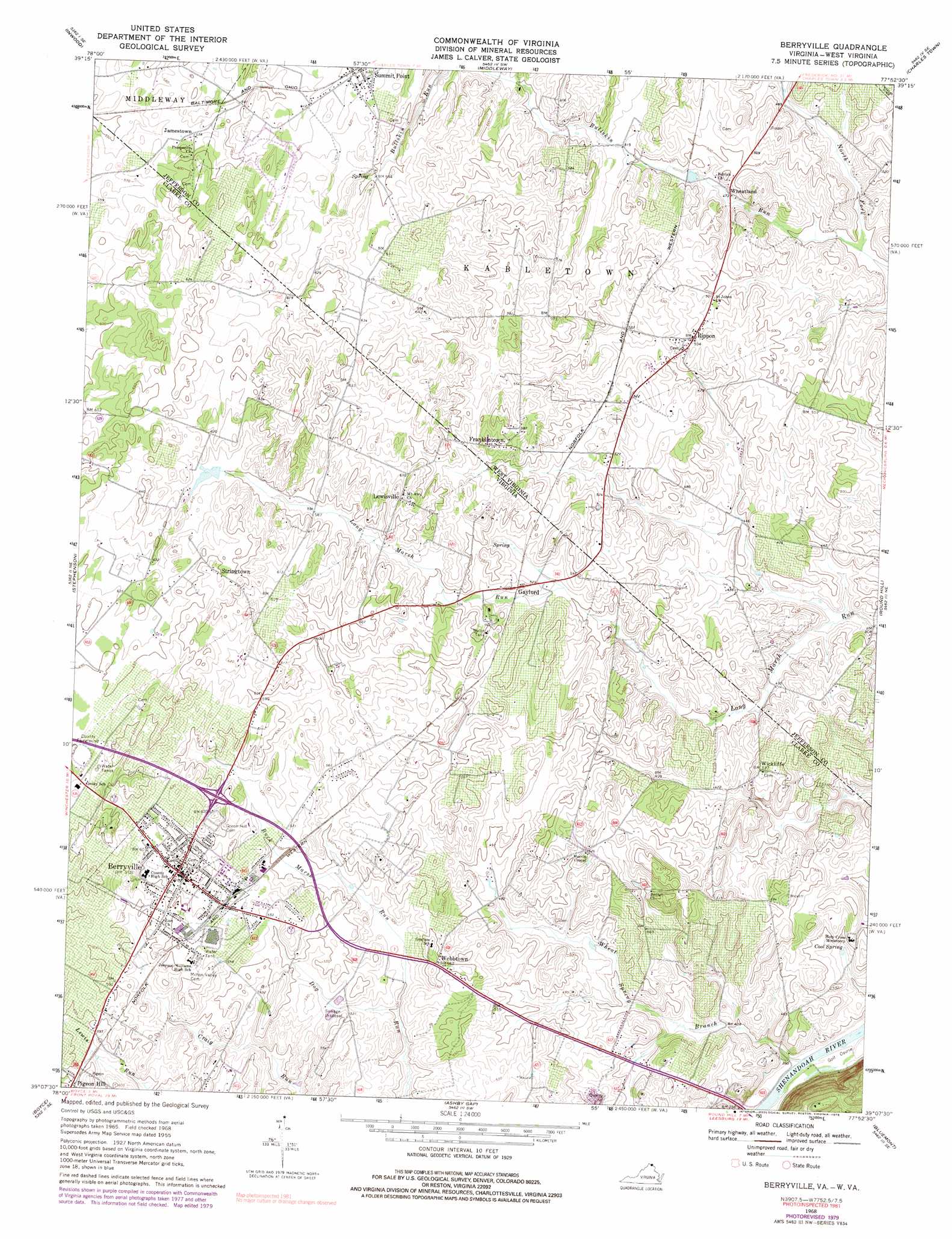
Berryville Topo Map Virginia
To zoom in, hover over the map of Berryville
USGS Topo Quad 39077b8 - 1:24,000 scale
| Topo Map Name: | Berryville |
| USGS Topo Quad ID: | 39077b8 |
| Print Size: | ca. 21 1/4" wide x 27" high |
| Southeast Coordinates: | 39.125° N latitude / 77.875° W longitude |
| Map Center Coordinates: | 39.1875° N latitude / 77.9375° W longitude |
| U.S. States: | VA, WV |
| Filename: | o39077b8.jpg |
| Download Map JPG Image: | Berryville topo map 1:24,000 scale |
| Map Type: | Topographic |
| Topo Series: | 7.5´ |
| Map Scale: | 1:24,000 |
| Source of Map Images: | United States Geological Survey (USGS) |
| Alternate Map Versions: |
Berryville VA 1953 Download PDF Buy paper map Berryville VA 1955, updated 1956 Download PDF Buy paper map Berryville VA 1968, updated 1969 Download PDF Buy paper map Berryville VA 1968, updated 1973 Download PDF Buy paper map Berryville VA 1968, updated 1979 Download PDF Buy paper map Berryville VA 1968, updated 1981 Download PDF Buy paper map Berryville VA 1997, updated 2001 Download PDF Buy paper map Berryville VA 2010 Download PDF Buy paper map Berryville VA 2013 Download PDF Buy paper map Berryville VA 2016 Download PDF Buy paper map |
1:24,000 Topo Quads surrounding Berryville
Glengary |
Tablers Station |
Martinsburg |
Shepherdstown |
Keedysville |
White Hall |
Inwood |
Middleway |
Charles Town |
Harpers Ferry |
Winchester |
Stephenson |
Berryville |
Round Hill |
Purcellville |
Stephens City |
Boyce |
Ashby Gap |
Bluemont |
Lincoln |
Front Royal |
Linden |
Upperville |
Rectortown |
Middleburg |
> Back to 39077a1 at 1:100,000 scale
> Back to 39076a1 at 1:250,000 scale
> Back to U.S. Topo Maps home
Berryville topo map: Gazetteer
Berryville: Parks
Berryville Historic District elevation 185m 606′Clarke County Fairgrounds elevation 199m 652′
Rixey Moore Memorial Park elevation 177m 580′
Berryville: Populated Places
Apple Glen elevation 180m 590′Arcadia Farm elevation 146m 479′
Battletown elevation 172m 564′
Berryville elevation 180m 590′
Blue Ridge Estates elevation 147m 482′
Bradfield elevation 173m 567′
Crown Estates elevation 186m 610′
Fairfield elevation 191m 626′
Franklintown elevation 175m 574′
Gaylord elevation 168m 551′
Jamestown elevation 177m 580′
Kinfield Estates elevation 186m 610′
Lewisville elevation 192m 629′
Longmarsh Acres elevation 192m 629′
Rippon elevation 162m 531′
Rockcroft elevation 185m 606′
Stringtown elevation 201m 659′
Summit Point elevation 192m 629′
Trapp Hill elevation 176m 577′
Treadwell elevation 180m 590′
Vista Estates elevation 152m 498′
Webbtown elevation 171m 561′
Wheatland elevation 144m 472′
Wickliffe elevation 163m 534′
Wilson elevation 184m 603′
Berryville: Post Offices
Berryville Post Office elevation 180m 590′Gaylord Post Office (historical) elevation 162m 531′
Rippon Post Office elevation 158m 518′
Summit Point Post Office elevation 191m 626′
Berryville: Springs
Adams Farm Spring elevation 143m 469′Baker Farm Spring elevation 159m 521′
Cool Spring elevation 128m 419′
Dr Boyd Farm Spring elevation 140m 459′
Dr Frey Farm Spring elevation 137m 449′
Dr Langdon Farm Spring elevation 126m 413′
Fairfax Grant Farm Springs elevation 169m 554′
Harrison Farm Spring elevation 172m 564′
Head Spring elevation 191m 626′
Henry Baker Farm Spring elevation 146m 479′
Joseph Bell Farm Spring elevation 149m 488′
Keller and Lackey Farms Springs elevation 160m 524′
Lippett Springs elevation 155m 508′
Locust Hill Farm Spring elevation 154m 505′
Rock Spring elevation 156m 511′
Berryville: Streams
Buck Marsh Run elevation 153m 501′North Fork Bullskin Run elevation 134m 439′
Wheat Spring Branch elevation 112m 367′
Berryville: Summits
Grindstone Hill elevation 180m 590′Berryville digital topo map on disk
Buy this Berryville topo map showing relief, roads, GPS coordinates and other geographical features, as a high-resolution digital map file on DVD:
Atlantic Coast (NY, NJ, PA, DE, MD, VA, NC)
Buy digital topo maps: Atlantic Coast (NY, NJ, PA, DE, MD, VA, NC)
 map DVD")