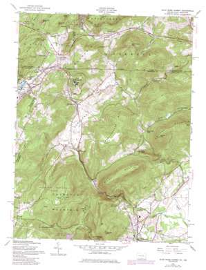
Blue Ridge Summit Topo Map Maryland
To zoom in, hover over the map of Blue Ridge Summit
USGS Topo Quad 39077f4 - 1:24,000 scale
| Topo Map Name: | Blue Ridge Summit |
| USGS Topo Quad ID: | 39077f4 |
| Print Size: | ca. 21 1/4" wide x 27" high |
| Southeast Coordinates: | 39.625° N latitude / 77.375° W longitude |
| Map Center Coordinates: | 39.6875° N latitude / 77.4375° W longitude |
| U.S. States: | MD, PA |
| Filename: | o39077f4.jpg |
| Download Map JPG Image: | Blue Ridge Summit topo map 1:24,000 scale |
| Map Type: | Topographic |
| Topo Series: | 7.5´ |
| Map Scale: | 1:24,000 |
| Source of Map Images: | United States Geological Survey (USGS) |
| Alternate Map Versions: |
Blue Ridge Summit PA 1953, updated 1955 Download PDF Buy paper map Blue Ridge Summit PA 1953, updated 1955 Download PDF Buy paper map Blue Ridge Summit PA 1953, updated 1961 Download PDF Buy paper map Blue Ridge Summit PA 1953, updated 1968 Download PDF Buy paper map Blue Ridge Summit PA 1953, updated 1972 Download PDF Buy paper map Blue Ridge Summit PA 1953, updated 1986 Download PDF Buy paper map Blue Ridge Summit PA 1953, updated 1986 Download PDF Buy paper map Blue Ridge Summit PA 2011 Download PDF Buy paper map Blue Ridge Summit PA 2013 Download PDF Buy paper map Blue Ridge Summit PA 2016 Download PDF Buy paper map |
1:24,000 Topo Quads surrounding Blue Ridge Summit
> Back to 39077e1 at 1:100,000 scale
> Back to 39076a1 at 1:250,000 scale
> Back to U.S. Topo Maps home
Blue Ridge Summit topo map: Gazetteer
Blue Ridge Summit: Bridges
Roddy Road Covered Bridge elevation 140m 459′Blue Ridge Summit: Cliffs
Clermont Crag elevation 494m 1620′Blue Ridge Summit: Dams
Emmitsburg Dam elevation 274m 898′Hunting Creek Dam elevation 314m 1030′
Lower Lake Royer Dam elevation 405m 1328′
Upper Lake Royer Dam elevation 406m 1332′
Blue Ridge Summit: Falls
Cunningham Falls elevation 380m 1246′Blue Ridge Summit: Lakes
Lake Royer elevation 405m 1328′Blue Ridge Summit: Parks
Camp Greentop Historic District elevation 533m 1748′Camp Misty Mount Historic District elevation 351m 1151′
Catoctin Mountain Park elevation 548m 1797′
Eyler Road Recreation Area elevation 174m 570′
Roddy Road Park elevation 145m 475′
Seymour B Cooper Memorial Wildlife Sanctuary elevation 367m 1204′
Blue Ridge Summit: Pillars
Wolf Rock elevation 426m 1397′Blue Ridge Summit: Populated Places
Bellemere Estates elevation 139m 456′Blue Ridge Summit elevation 410m 1345′
Browns Store (historical) elevation 475m 1558′
Carroll Valley elevation 185m 606′
Cascade elevation 411m 1348′
Catoctin Heights elevation 193m 633′
Catoctin Highlands elevation 170m 557′
Charmian elevation 376m 1233′
Colonial Heights elevation 158m 518′
Distant View elevation 195m 639′
Eyeler (historical) elevation 288m 944′
Flint elevation 250m 820′
Fountain Dale elevation 239m 784′
Foxville elevation 443m 1453′
Friends Creek elevation 201m 659′
Friendship elevation 278m 912′
Highfield elevation 426m 1397′
Lost Valley elevation 182m 597′
Manahan Ranch Estates elevation 328m 1076′
Monterey elevation 408m 1338′
Pennersville elevation 415m 1361′
Ridgeview elevation 134m 439′
Roddy (historical) elevation 152m 498′
Rowland Hill elevation 476m 1561′
Sabillasville elevation 332m 1089′
Shamrock Acres elevation 292m 958′
Smithbrook Acres elevation 164m 538′
Staubs Thurmont Acres elevation 162m 531′
Thurmont West elevation 190m 623′
Whispering Pines elevation 148m 485′
Blue Ridge Summit: Post Offices
Cascade Post Office elevation 418m 1371′Highfield Post Office elevation 430m 1410′
Lantz Post Office elevation 293m 961′
Sabillasville Post Office elevation 351m 1151′
Blue Ridge Summit: Reservoirs
Emmitsburg Reservoir elevation 231m 757′Hunting Creek Lake elevation 314m 1030′
Lake Royer elevation 403m 1322′
Rainbow Lake elevation 274m 898′
Blue Ridge Summit: Springs
Browns Spring elevation 396m 1299′Fountaindale Spring elevation 190m 623′
Blue Ridge Summit: Streams
Devils Run elevation 384m 1259′Hauver Branch elevation 302m 990′
Little Owens Creek elevation 128m 419′
Blue Ridge Summit: Summits
Bare Rock elevation 501m 1643′Buzzards Roost elevation 458m 1502′
Carrick Knob elevation 495m 1624′
Catoctin Mountain elevation 572m 1876′
Chimney Rock elevation 427m 1400′
College Mountain elevation 520m 1706′
Derr Hill elevation 454m 1489′
Haycock elevation 397m 1302′
Little Piney Mountain elevation 395m 1295′
Monterey Peak elevation 507m 1663′
Mount Dunlop elevation 513m 1683′
Piney Mountain elevation 524m 1719′
Raven Rock Mountain elevation 462m 1515′
Round Top elevation 520m 1706′
Tunnel Hill elevation 451m 1479′
Wertenbaker Hill elevation 493m 1617′
Blue Ridge Summit: Trails
Cunningham Falls Nature Trail elevation 375m 1230′High Rock Nature Trail elevation 498m 1633′
Spiderbush Nature Trail elevation 519m 1702′
Blue Ridge Summit: Tunnels
Jacks Mountain Tunnel elevation 393m 1289′Blue Ridge Summit: Valleys
Cove Hollow elevation 184m 603′Eylers Valley elevation 270m 885′
Harbaugh Valley elevation 242m 793′
Blue Ridge Summit: Woods
Blacks Hilltop Orchard elevation 262m 859′Blue Ridge Summit digital topo map on disk
Buy this Blue Ridge Summit topo map showing relief, roads, GPS coordinates and other geographical features, as a high-resolution digital map file on DVD:
Atlantic Coast (NY, NJ, PA, DE, MD, VA, NC)
Buy digital topo maps: Atlantic Coast (NY, NJ, PA, DE, MD, VA, NC)


