Williamson Topo Map Pennsylvania
To zoom in, hover over the map of Williamson
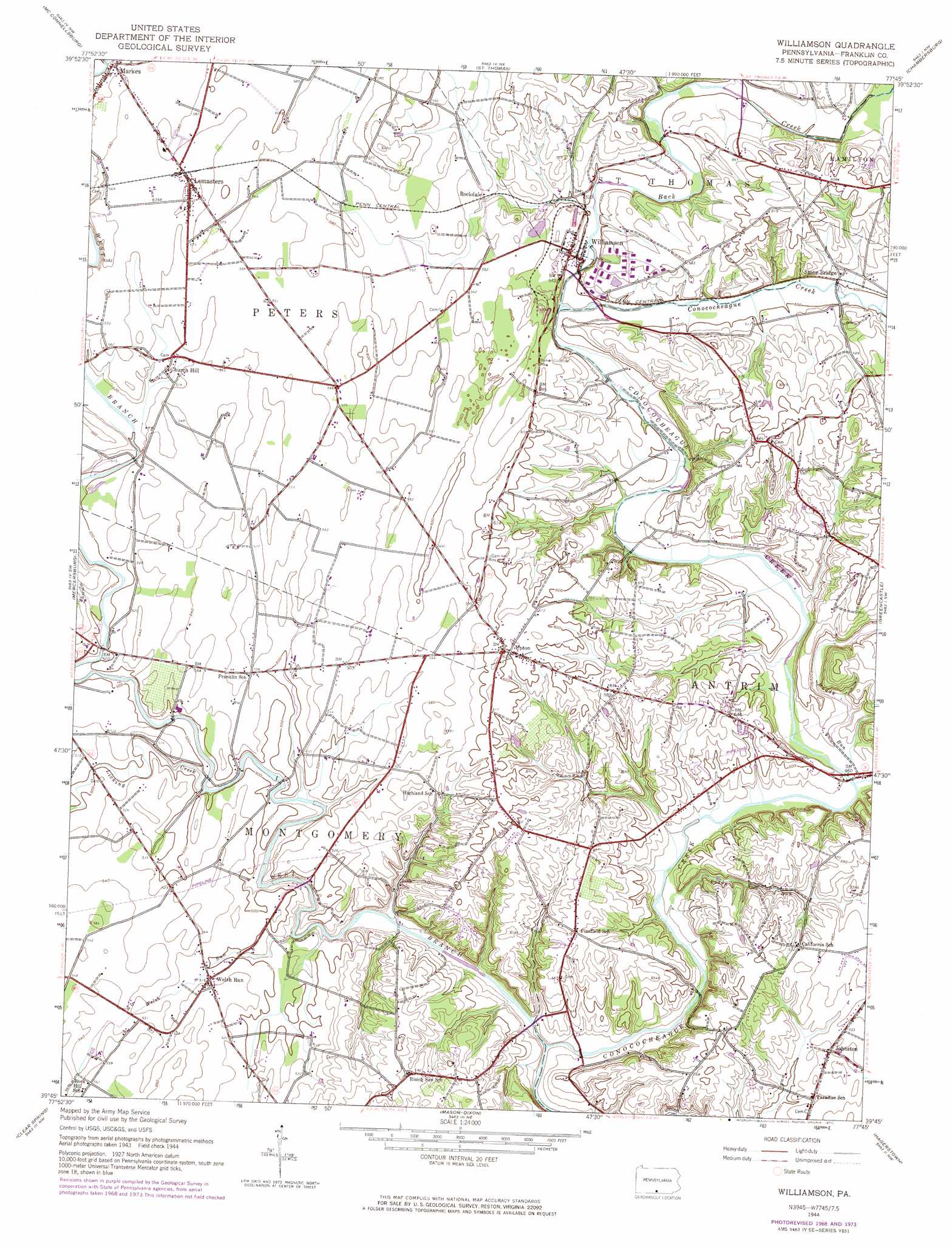
USGS Topo Quad 39077g7 - 1:24,000 scale
| Topo Map Name: | Williamson |
| USGS Topo Quad ID: | 39077g7 |
| Print Size: | ca. 21 1/4" wide x 27" high |
| Southeast Coordinates: | 39.75° N latitude / 77.75° W longitude |
| Map Center Coordinates: | 39.8125° N latitude / 77.8125° W longitude |
| U.S. State: | PA |
| Filename: | o39077g7.jpg |
| Download Map JPG Image: | Williamson topo map 1:24,000 scale |
| Map Type: | Topographic |
| Topo Series: | 7.5´ |
| Map Scale: | 1:24,000 |
| Source of Map Images: | United States Geological Survey (USGS) |
| Alternate Map Versions: |
Williamson PA 1944, updated 1960 Download PDF Buy paper map Williamson PA 1944, updated 1969 Download PDF Buy paper map Williamson PA 1944, updated 1974 Download PDF Buy paper map Williamson PA 1990, updated 1995 Download PDF Buy paper map Williamson PA 2010 Download PDF Buy paper map Williamson PA 2013 Download PDF Buy paper map Williamson PA 2016 Download PDF Buy paper map |
1:24,000 Topo Quads surrounding Williamson
Hustontown |
Burnt Cabins |
Fannettsburg |
Roxbury |
Shippensburg |
Meadow Grounds |
Mcconnellsburg |
Saint Thomas |
Chambersburg |
Scotland |
Big Cove Tannery |
Mercersburg |
Williamson |
Greencastle |
Waynesboro |
Cherry Run |
Clear Spring |
Mason-Dixon |
Hagerstown |
Smithsburg |
Big Pool |
Hedgesville |
Williamsport |
Funkstown |
Myersville |
> Back to 39077e1 at 1:100,000 scale
> Back to 39076a1 at 1:250,000 scale
> Back to U.S. Topo Maps home
Williamson topo map: Gazetteer
Williamson: Airports
JJ and PK Airport elevation 162m 531′Williamson: Bridges
Martins Mill Covered Bridge elevation 131m 429′Williamson: Parks
Enoch Brown Memorial Park elevation 165m 541′Williamson: Populated Places
Bino elevation 177m 580′Church Hill elevation 165m 541′
Johnston elevation 163m 534′
Lemasters elevation 176m 577′
Markes elevation 177m 580′
Rockdale elevation 158m 518′
Upton elevation 186m 610′
Vanilla elevation 163m 534′
Welsh Run elevation 157m 515′
Williamson elevation 148m 485′
Williamson: Streams
Back Creek elevation 145m 475′Campbell Run elevation 151m 495′
Licking Creek elevation 141m 462′
Muddy Run elevation 137m 449′
Paddy Run elevation 133m 436′
Welsh Run elevation 133m 436′
West Branch Conococheague Creek elevation 127m 416′
Williamson digital topo map on disk
Buy this Williamson topo map showing relief, roads, GPS coordinates and other geographical features, as a high-resolution digital map file on DVD:
Atlantic Coast (NY, NJ, PA, DE, MD, VA, NC)
Buy digital topo maps: Atlantic Coast (NY, NJ, PA, DE, MD, VA, NC)
 map DVD")