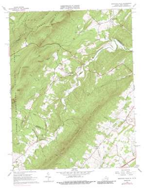
Mountain Falls Topo Map Virginia
To zoom in, hover over the map of Mountain Falls
USGS Topo Quad 39078a4 - 1:24,000 scale
| Topo Map Name: | Mountain Falls |
| USGS Topo Quad ID: | 39078a4 |
| Print Size: | ca. 21 1/4" wide x 27" high |
| Southeast Coordinates: | 39° N latitude / 78.375° W longitude |
| Map Center Coordinates: | 39.0625° N latitude / 78.4375° W longitude |
| U.S. States: | VA, WV |
| Filename: | o39078a4.jpg |
| Download Map JPG Image: | Mountain Falls topo map 1:24,000 scale |
| Map Type: | Topographic |
| Topo Series: | 7.5´ |
| Map Scale: | 1:24,000 |
| Source of Map Images: | United States Geological Survey (USGS) |
| Alternate Map Versions: |
Mountain Falls VA 1965, updated 1968 Download PDF Buy paper map Mountain Falls VA 1965, updated 1976 Download PDF Buy paper map Mountain Falls VA 1965, updated 1987 Download PDF Buy paper map Mountain Falls VA 1999, updated 2001 Download PDF Buy paper map Mountain Falls VA 2011 Download PDF Buy paper map Mountain Falls VA 2013 Download PDF Buy paper map Mountain Falls VA 2016 Download PDF Buy paper map |
| FStopo: | US Forest Service topo Mountain Falls is available: Download FStopo PDF Download FStopo TIF |
1:24,000 Topo Quads surrounding Mountain Falls
> Back to 39078a1 at 1:100,000 scale
> Back to 39078a1 at 1:250,000 scale
> Back to U.S. Topo Maps home
Mountain Falls topo map: Gazetteer
Mountain Falls: Airports
Mulberry Run Airport elevation 243m 797′Mountain Falls: Basins
Bear Wallow elevation 553m 1814′Mountain Falls: Cliffs
Dog Cliff elevation 622m 2040′Mountain Falls: Dams
Seven Vistas Dam elevation 255m 836′Mountain Falls: Gaps
Cold Spring Gap elevation 566m 1856′Dry Gap elevation 641m 2103′
Dry Gap elevation 643m 2109′
Paddy Gap elevation 397m 1302′
Pontzer Gap elevation 598m 1961′
Mountain Falls: Populated Places
Gravel Springs elevation 261m 856′Mountain Falls elevation 257m 843′
Zepp elevation 329m 1079′
Mountain Falls: Post Offices
Star Tannery Post Office elevation 259m 849′Mountain Falls: Reservoirs
Seven Vistas Lake elevation 255m 836′Mountain Falls: Ridges
Limestone Ridge elevation 380m 1246′McIiwee Ridge elevation 367m 1204′
Mineral Ridge elevation 433m 1420′
Tarkiln Ridge elevation 437m 1433′
The Half Moon elevation 547m 1794′
Mountain Falls: Springs
Pembroke Springs elevation 270m 885′Mountain Falls: Streams
Bakers Run elevation 233m 764′Cold Spring Run elevation 279m 915′
Duck Run elevation 223m 731′
Gravel Springs Run elevation 239m 784′
Hockmans Run elevation 250m 820′
Laurel Run elevation 264m 866′
Paddy Run elevation 273m 895′
Richards Run elevation 245m 803′
Shell Run elevation 285m 935′
Mountain Falls: Summits
Eagle Rock elevation 787m 2582′Eagle Rock elevation 791m 2595′
Johnnies Knob elevation 803m 2634′
Pinnacle Rock elevation 636m 2086′
Short Mountain elevation 631m 2070′
Spring Mountain elevation 738m 2421′
Mountain Falls: Valleys
Polebridge Hollow elevation 320m 1049′Poplar Hollow elevation 267m 875′
Rocky Hollow elevation 331m 1085′
Mountain Falls digital topo map on disk
Buy this Mountain Falls topo map showing relief, roads, GPS coordinates and other geographical features, as a high-resolution digital map file on DVD:


